TopoQuest Logo
Do you find TopoQuest useful?
Help keep TopoQuest running and adding new maps/features by donating!
Bitcoin:  19c7KJd3qBynnjoSw5npx9KScwjBe4ifkT
Litecoin:  LXs6TkuXGGXo1vDsWCkWVdjQX94eUKd6ui
Home View Maps Find Maps Find Places Resources & Links


Wakefield, Michigan Topographic Map

USGS Map Title: Wakefield, MI
USGS Map MRC: 46089D8
DRG (GeoTIFF) Download: o46089d8.tif


Neighboring USGS Topographic Map Quads:


  Bessemer, MI  
46090D1
 

  Wakefield, MI  
46089D8
 

  Wakefield NE, MI  
46089D7
 

  Lake Evelyn, WI  
46090C1
 

  Chaney Lake, MI  
46089C8
 

  Harris Lake, WI  
46089C7


Map MRC Location:

N47°
W90°
N47°
W89°
H8 H7 H6 H5 H4 H3 H2 H1
G8 G7 G6 G5 G4 G3 G2 G1
F8 F7 F6 F5 F4 F3 F2 F1
E8 E7 E6 E5 E4 E3 E2 E1
D8 D7 D6 D5 D4 D3 D2 D1
C8 C7 C6 C5 C4 C3 C2 C1
B8 B7 B6 B5 B4 B3 B2 B1
A8 A7 A6 A5 A4 A3 A2 A1
N46°
W90°
N46°
W89°

Wakefield, MI USGS 1:24K Topographic Map Preview:
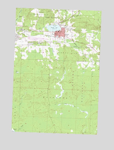
Wakefield, MI USGS Topographic Map
Click on map above to begin viewing in our Map Viewer.

This topographic map contains these locations and features:
Feature Name Type Latitude Longitude GNIS ID View Map
All Saints Lutheran ChurchChurchN46.4781°W89.9317°2126098View Map
Alward CreekStreamN46.4791°W89.8779°1619019View Map
Bice CreekStreamN46.3755°W89.9941°1619179View Map
Calvary Baptist ChurchChurchN46.4731°W89.9308°2126100View Map
Cim CreekStreamN46.4530°W89.9674°1622711View Map
City of WakefieldCivilN46.4766°W89.9339°1627204View Map
Eddy ParkParkN46.4844°W89.9399°1619829View Map
Gogebic County HomeBuildingN46.4652°W89.9643°1622710View Map
Grace Baptist ChurchChurchN46.4733°W89.9406°2126101View Map
Grace Open ChurchChurchN46.4703°W89.9953°2126301View Map
Immaculate Conception ChurchChurchN46.4739°W89.9425°2126102View Map
Lakeside CemeteryCemeteryN46.4676°W89.9469°1620478View Map
Little Black RiverStreamN46.4883°W89.9968°1620539View Map
Michigan State Police District 8 Wakefield Post 86BuildingN46.4773°W89.9406°2767920View Map
Neepikon FallsFallsN46.4911°W89.9963°1620993View Map
PlymouthPopulated PlaceN46.4647°W89.9796°1621266View Map
Plymouth MineMineN46.4702°W89.9668°1622709View Map
RamsayPopulated PlaceN46.4702°W89.9966°1621339View Map
Ramsay Lookout TowerTowerN46.4258°W89.9941°1623590View Map
Rocco Medical ClinicHospitalN46.4722°W89.9417°2126104View Map
Sunday LakeReservoirN46.4805°W89.9627°1621829View Map
Sunday Lake MineMineN46.4836°W89.9285°1621830View Map
Township of BessemerCivilN46.3819°W89.9325°1625929View Map
Trout Creek Fire HallBuildingN46.4878°W89.9875°2125285View Map
VeronaPopulated PlaceN46.4774°W89.9891°1622021View Map
Verona Lookout TowerTowerN46.4963°W89.9660°1623684View Map
Verona Post Office (historical)Post OfficeN46.4775°W89.9892°2126067View Map
WakefieldPopulated PlaceN46.4752°W89.9399°1622046View Map
Wakefield - Marenisco SchoolSchoolN46.4777°W89.9374°2126107View Map
Wakefield City LibraryBuildingN46.4750°W89.9425°2126103View Map
Wakefield Police DepartmentBuildingN46.4778°W89.9394°2126106View Map
Wakefield Post OfficePost OfficeN46.4749°W89.9418°2126105View Map
Wakefield Station (historical)LocaleN46.4719°W89.9383°2126108View Map
Wakefield United Methodist ChurchChurchN46.4764°W89.9375°2126099View Map
Wakefield Volunteer Fire DepartmentBuildingN46.4720°W89.9415°2627052View Map
WicoPopulated PlaceN46.4658°W89.9635°1622154View Map

Note: Coordinates in the location and feature list above are referenced to NAD83 datum.


Copyright (C) 2008-2024 Ryan Niemi / Sunset Dynamics ... All Rights Reserved