TopoQuest Logo
Do you find TopoQuest useful?
Help keep TopoQuest running and adding new maps/features by donating!
Bitcoin:  19c7KJd3qBynnjoSw5npx9KScwjBe4ifkT
Litecoin:  LXs6TkuXGGXo1vDsWCkWVdjQX94eUKd6ui
Home View Maps Find Maps Find Places Resources & Links


Chaney Lake, Michigan Topographic Map

USGS Map Title: Chaney Lake, MI
USGS Map MRC: 46089C8
DRG (GeoTIFF) Download: o46089c8.tif


Neighboring USGS Topographic Map Quads:


  Bessemer, MI  
46090D1
 

  Wakefield, MI  
46089D8
 

  Wakefield NE, MI  
46089D7
 

  Lake Evelyn, WI  
46090C1
 

  Chaney Lake, MI  
46089C8
 

  Harris Lake, WI  
46089C7
 

  Mercer, WI  
46090B1
 

  Winchester, WI  
46089B8
 

  Papoose Lake, WI  
46089B7


Map MRC Location:

N47°
W90°
N47°
W89°
H8 H7 H6 H5 H4 H3 H2 H1
G8 G7 G6 G5 G4 G3 G2 G1
F8 F7 F6 F5 F4 F3 F2 F1
E8 E7 E6 E5 E4 E3 E2 E1
D8 D7 D6 D5 D4 D3 D2 D1
C8 C7 C6 C5 C4 C3 C2 C1
B8 B7 B6 B5 B4 B3 B2 B1
A8 A7 A6 A5 A4 A3 A2 A1
N46°
W90°
N46°
W89°

Chaney Lake, MI USGS 1:24K Topographic Map Preview:
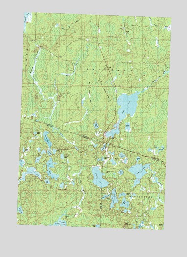
Chaney Lake, MI USGS Topographic Map
Click on map above to begin viewing in our Map Viewer.

This topographic map contains these locations and features:
Feature Name Type Latitude Longitude GNIS ID View Map
Beatrice LakeLakeN46.2888°W89.9203°1561411View Map
Bena LakeLakeN46.2913°W89.8994°1561553View Map
Camp Twelve LakeLakeN46.2738°W89.9631°1562572View Map
Chaney LakeLakeN46.3198°W89.9117°623075View Map
Christopher CreekStreamN46.3731°W89.9153°2099925View Map
Constance LakeLakeN46.2648°W89.9089°1563332View Map
Cranberry LakeLakeN46.2937°W89.9703°1563492View Map
Dumbell LakeLakeN46.2898°W89.9308°1833696View Map
Etna LakeLakeN46.2970°W89.9288°1564704View Map
Findler LakeLakeN46.2603°W89.9080°1564940View Map
Fox LakeLakeN46.2828°W89.9130°1565221View Map
George LakeLakeN46.2673°W89.9186°1565466View Map
Gretchen LakeLakeN46.2930°W89.9127°1565895View Map
Hawk LakeLakeN46.2584°W89.9974°1566156View Map
Hewitt LakeLakeN46.3006°W89.9767°1566339View Map
Hill LakeLakeN46.2759°W89.9753°1566420View Map
Hook LakeLakeN46.2971°W89.8800°628539View Map
Jeannie LakeLakeN46.2911°W89.9635°1567109View Map
Joann LakeLakeN46.3101°W89.9088°629287View Map
Lake FranchianLakeN46.2900°W89.9095°1565245View Map
Lake HelenLakeN46.2516°W89.8952°1566274View Map
Lake RoseLakeN46.2524°W89.9008°2095693View Map
Lake YolandaLakeN46.2540°W89.8934°1577100View Map
Little Oak LakeLakeN46.2938°W89.9964°1568339View Map
Lynx LakeLakeN46.2978°W89.8833°631238View Map
Marell LakeLakeN46.3099°W89.9357°631542View Map
Marion LakeLakeN46.2682°W89.9257°1569046View Map
Mary LakeLakeN46.2507°W89.9004°2095691View Map
Mary Lake State Natural AreaParkN46.2517°W89.9000°2095692View Map
McFadyen DamDamN46.2883°W89.9168°1792476View Map
Mosinee CreekStreamN46.3241°W89.9729°632748View Map
Negro LakesLakeN46.2886°W89.9840°1570145View Map
No Mans CreekStreamN46.2861°W89.8899°1580014View Map
No Mans LakeLakeN46.2835°W89.8980°1570322View Map
Oak LakeLakeN46.2863°W89.9978°1570661View Map
Otter LakeLakeN46.3041°W89.9871°1570915View Map
Owl LakeLakeN46.2791°W89.9713°1570967View Map
Pardee CreekStreamN46.2547°W89.9638°1571027View Map
Pardee LakeLakeN46.2791°W89.9316°1571028View Map
Spinnet LakeLakeN46.2928°W89.9746°1574552View Map
Swamp LakeLakeN46.2989°W89.9907°2772188View Map
Troste Lookout TowerTowerN46.2516°W89.9085°1581355View Map
Trostel LakeLakeN46.2697°W89.9113°1575657View Map
Virgin LakeLakeN46.2803°W89.9898°1576116View Map
Woods LakeLakeN46.2946°W89.9836°2772190View Map

Note: Coordinates in the location and feature list above are referenced to NAD83 datum.


Copyright (C) 2008-2025 Ryan Niemi / Sunset Dynamics ... All Rights Reserved