TopoQuest Logo
Do you find TopoQuest useful?
Help keep TopoQuest running and adding new maps/features by donating!
Bitcoin:  19c7KJd3qBynnjoSw5npx9KScwjBe4ifkT
Litecoin:  LXs6TkuXGGXo1vDsWCkWVdjQX94eUKd6ui
Home View Maps Find Maps Find Places Resources & Links


Walkers, Virginia Topographic Map

USGS Map Title: Walkers, VA
USGS Map MRC: 37076D8
DRG (GeoTIFF) Download: o37076d8.tif


Neighboring USGS Topographic Map Quads:


  Tunstall, VA  
37077E1
 

  New Kent, VA  
37076E8
 

  West Point, VA  
37076E7
 

  Providence Forge, VA  
37077D1
 

  Walkers, VA  
37076D8
 

  Toano, VA  
37076D7
 

  Charles City, VA  
37077C1
 

  Brandon, VA  
37076C8
 

  Norge, VA  
37076C7


Map MRC Location:

N38°
W77°
N38°
W76°
H8 H7 H6 H5 H4 H3 H2 H1
G8 G7 G6 G5 G4 G3 G2 G1
F8 F7 F6 F5 F4 F3 F2 F1
E8 E7 E6 E5 E4 E3 E2 E1
D8 D7 D6 D5 D4 D3 D2 D1
C8 C7 C6 C5 C4 C3 C2 C1
B8 B7 B6 B5 B4 B3 B2 B1
A8 A7 A6 A5 A4 A3 A2 A1
N37°
W77°
N37°
W76°

Walkers, VA USGS 1:24K Topographic Map Preview:
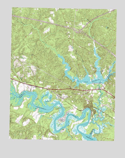
Walkers, VA USGS Topographic Map
Click on map above to begin viewing in our Map Viewer.

This topographic map contains these locations and features:
Feature Name Type Latitude Longitude GNIS ID View Map
Balls PondReservoirN37.4828°W76.8865°1462754View Map
Barnes SwampStreamN37.4324°W76.8875°1478145View Map
Barrows CreekStreamN37.3863°W76.9327°1478154View Map
Beaverdam CreekStreamN37.4635°W76.9000°1462960View Map
Big SwampStreamN37.4157°W76.9869°1478215View Map
Binns BarBarN37.4004°W76.9550°1478217View Map
Chickahominy Lake (historical)LakeN37.4038°W76.9561°1478078View Map
Chickahominy OutpostLocaleN37.4057°W76.9319°1739793View Map
Chickahominy ShoresPopulated PlaceN37.3938°W76.9411°1499254View Map
Colonial Golf ClubLocaleN37.3932°W76.8768°2520153View Map
Colonial Harbor MarinaHarborN37.4017°W76.9128°2520091View Map
Cypress Bank LandingLocaleN37.4049°W76.9664°1499318View Map
Diascund BridgeBridgeN37.4251°W76.8764°1739795View Map
Diascund CreekStreamN37.3796°W76.9033°1465759View Map
Diascund Creek ReservoirReservoirN37.4323°W76.9064°1465760View Map
Diascund DamDamN37.4293°W76.9022°1490448View Map
Diascund ReservoirReservoirN37.4325°W76.8876°1490449View Map
District 5CivilN37.4718°W76.9711°1927267View Map
Eastern Chickahominy State Designated Tribal Statistical AreaCensusN37.4363°W76.9732°2418562View Map
Ebenezer ChurchChurchN37.4193°W76.9241°1466144View Map
Fish Hole LandingLocaleN37.4029°W76.9030°1499415View Map
Golf Club at BrickshireLocaleN37.4783°W76.9947°2520145View Map
Good Hope ChurchChurchN37.4754°W76.9327°1467208View Map
Goodhope School (historical)SchoolN37.4757°W76.9330°1739797View Map
Graves LandingLocaleN37.3851°W76.9369°1499490View Map
Hicks IslandIslandN37.3996°W76.8927°1478750View Map
Interchange 220CrossingN37.4788°W76.9191°1739801View Map
Johnson CreekStreamN37.4068°W76.9544°1468795View Map
Lacey CreekStreamN37.4065°W76.9586°1469088View Map
LanexaPopulated PlaceN37.4238°W76.9011°1499643View Map
Lanexa Post OfficePost OfficeN37.4225°W76.8999°2519628View Map
Liberty ChurchChurchN37.4249°W76.8941°1469363View Map
Matahunk NeckCapeN37.4024°W76.9452°1479059View Map
Mill CreekStreamN37.3874°W76.8919°1479093View Map
Mount Pleasant ChurchChurchN37.4549°W76.9739°1471041View Map
New Kent Fire - Rescue Station 3 / Weir Creek Volunteer Emergency ServicesBuildingN37.4998°W76.8797°2331878View Map
New Kent Fire - Rescue Station 4 / Lanexa Volunteer Fire and Emergency Medical ServicesBuildingN37.4238°W76.9018°2768998View Map
Osborn LandingPopulated PlaceN37.4138°W76.9686°1477597View Map
Rock-A-HockLocaleN37.4143°W76.9366°1473397View Map
SlatervillePopulated PlaceN37.4990°W76.9422°1477762View Map
Timber SwampStreamN37.4382°W76.9075°1475729View Map
Tonyham SwampStreamN37.4146°W76.9922°1479747View Map
Tradition Golf Club at Royal New KentLocaleN37.4712°W76.9927°2520197View Map
Tsena Commoko ChurchChurchN37.4249°W76.9686°1475904View Map
Turner NeckCapeN37.3918°W76.9375°1475987View Map
Vaidens Pond (historical)ReservoirN37.4307°W76.9202°1739822View Map
Wahrani SwampStreamN37.4324°W76.8877°1479808View Map
WalkersPopulated PlaceN37.4154°W76.9400°1477850View Map
WDCK-FM (Williamsburg)TowerN37.4288°W76.9444°1502729View Map
Wilcox NeckCapeN37.3965°W76.9089°1479884View Map
Windsor ShadesLocaleN37.4279°W76.9830°1476854View Map

Note: Coordinates in the location and feature list above are referenced to NAD83 datum.


Copyright (C) 2008-2025 Ryan Niemi / Sunset Dynamics ... All Rights Reserved