TopoQuest Logo
Do you find TopoQuest useful?
Help keep TopoQuest running and adding new maps/features by donating!
Bitcoin:  19c7KJd3qBynnjoSw5npx9KScwjBe4ifkT
Litecoin:  LXs6TkuXGGXo1vDsWCkWVdjQX94eUKd6ui
Home View Maps Find Maps Find Places Resources & Links


Wallis, Texas Topographic Map

USGS Map Title: Wallis, TX
USGS Map MRC: 29096F1
DRG (GeoTIFF) Download: o29096f1.tif


Neighboring USGS Topographic Map Quads:


  Sealy, TX  
29096G2
 

  San Felipe, TX  
29096G1
 

  Brookshire, TX  
29095G8
 

  Rexville, TX  
29096F2
 

  Wallis, TX  
29096F1
 

  Fulshear, TX  
29095F8
 

  Lissie, TX  
29096E2
 

  East Bernard, TX  
29096E1
 

  Orchard, TX  
29095E8


Map MRC Location:

N30°
W97°
N30°
W96°
H8 H7 H6 H5 H4 H3 H2 H1
G8 G7 G6 G5 G4 G3 G2 G1
F8 F7 F6 F5 F4 F3 F2 F1
E8 E7 E6 E5 E4 E3 E2 E1
D8 D7 D6 D5 D4 D3 D2 D1
C8 C7 C6 C5 C4 C3 C2 C1
B8 B7 B6 B5 B4 B3 B2 B1
A8 A7 A6 A5 A4 A3 A2 A1
N29°
W97°
N29°
W96°

Wallis, TX USGS 1:24K Topographic Map Preview:
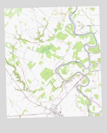
Wallis, TX USGS Topographic Map
Click on map above to begin viewing in our Map Viewer.

This topographic map contains these locations and features:
Feature Name Type Latitude Longitude GNIS ID View Map
Allen - Johnston CemeteryCemeteryN29.6713°W96.1113°1329400View Map
Allens CreekStreamN29.6655°W96.0463°1329401View Map
Alligator HoleSwampN29.7022°W96.0711°1329419View Map
Cannons LakeLakeN29.7130°W96.0192°1332101View Map
Church of the Guardian AngelChurchN29.6258°W96.0572°2032289View Map
City of WallisCivilN29.6317°W96.0637°2412171View Map
El PleasantLocaleN29.6747°W96.1200°1335246View Map
Evans ChapelChurchN29.6394°W96.0650°1335551View Map
Gloster AerodromeAirportN29.7332°W96.0611°1387519View Map
Hartville CemeteryCemeteryN29.6577°W96.1080°1337426View Map
Little Bethlehem ChurchChurchN29.6933°W96.0491°1340022View Map
Longbird AirportAirportN29.7483°W96.1147°1387518View Map
Mount Olive ChurchChurchN29.6455°W96.0536°1342071View Map
Mount Zion ChurchChurchN29.7277°W96.0800°1342137View Map
Nowaks LakeLakeN29.6999°W96.1167°1342906View Map
Parker ChapelChurchN29.6694°W96.1166°1343599View Map
Valley Lodge ClubhouseBuildingN29.6827°W96.0119°1349168View Map
WallisPopulated PlaceN29.6313°W96.0652°1376626View Map
Wallis CemeteryCemeteryN29.6458°W96.0563°1349407View Map
Wallis CemeteryCemeteryN29.6586°W96.0472°1349408View Map
Wallis City HallBuildingN29.6352°W96.0665°2753991View Map
Wallis DivisionCivilN29.6641°W96.1030°1939296View Map
Wallis Police DepartmentBuildingN29.6349°W96.0667°2375806View Map
Wallis Post OfficePost OfficeN29.6314°W96.0628°2731240View Map
Wallis Volunteer Fire DepartmentBuildingN29.6315°W96.0621°2334566View Map
Wards LakeLakeN29.7242°W96.0423°1349486View Map
West Mount Olive ChurchChurchN29.6602°W96.0038°1349765View Map
Williams SchoolSchoolN29.6372°W96.0602°1350148View Map

Note: Coordinates in the location and feature list above are referenced to NAD83 datum.


Copyright (C) 2008-2024 Ryan Niemi / Sunset Dynamics ... All Rights Reserved