TopoQuest Logo
Do you find TopoQuest useful?
Help keep TopoQuest running and adding new maps/features by donating!
Bitcoin:  19c7KJd3qBynnjoSw5npx9KScwjBe4ifkT
Litecoin:  LXs6TkuXGGXo1vDsWCkWVdjQX94eUKd6ui
Home View Maps Find Maps Find Places Resources & Links


Walls, Louisiana Topographic Map

USGS Map Title: Walls, LA
USGS Map MRC: 30091E3
DRG (GeoTIFF) Download: o30091e3.tif


Neighboring USGS Topographic Map Quads:


  New Roads, LA  
30091F4
 

  Port Hudson, LA  
30091F3
 

  Zachary, LA  
30091F2
 

  Erwinville, LA  
30091E4
 

  Walls, LA  
30091E3
 

  Scotlandville, LA  
30091E2
 

  Grosse Tete, LA  
30091D4
 

  Lobdell, LA  
30091D3
 

  Baton Rouge West, LA  
30091D2


Map MRC Location:

N31°
W92°
N31°
W91°
H8 H7 H6 H5 H4 H3 H2 H1
G8 G7 G6 G5 G4 G3 G2 G1
F8 F7 F6 F5 F4 F3 F2 F1
E8 E7 E6 E5 E4 E3 E2 E1
D8 D7 D6 D5 D4 D3 D2 D1
C8 C7 C6 C5 C4 C3 C2 C1
B8 B7 B6 B5 B4 B3 B2 B1
A8 A7 A6 A5 A4 A3 A2 A1
N30°
W92°
N30°
W91°

Walls, LA USGS 1:24K Topographic Map Preview:
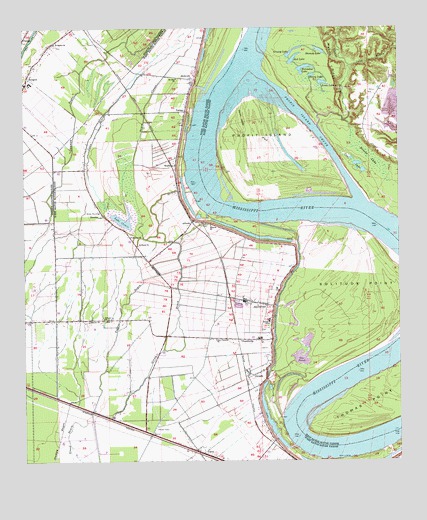
Walls, LA USGS Topographic Map
Click on map above to begin viewing in our Map Viewer.

This topographic map contains these locations and features:
Feature Name Type Latitude Longitude GNIS ID View Map
Alford CemeteryCemeteryN30.5682°W91.3159°532107View Map
AlfordsPopulated PlaceN30.5694°W91.3190°553280View Map
Allen LandingPopulated PlaceN30.5007°W91.2709°553286View Map
Allendale RevetmentLeveeN30.5038°W91.2551°542179View Map
ArbrothPopulated PlaceN30.6105°W91.3190°532201View Map
Arbroth LandingLocaleN30.6099°W91.3112°550996View Map
Arbroth RevetmentLeveeN30.5782°W91.3196°542180View Map
Ashland Plantation (historical)LocaleN30.5371°W91.3029°550997View Map
Barroza (historical)Populated PlaceN30.5057°W91.2940°551000View Map
Barroza LandingLocaleN30.5038°W91.2843°551001View Map
Batture Plantation (historical)LocaleN30.5585°W91.2937°551003View Map
Bayou ClauseStreamN30.5763°W91.3418°532527View Map
Brooks LakeSwampN30.5875°W91.2596°533420View Map
BuechePopulated PlaceN30.5710°W91.3484°543039View Map
Bueche ChurchChurchN30.5649°W91.3393°533513View Map
Bueche Post OfficePost OfficeN30.5649°W91.3404°1631578View Map
Calvary ChurchChurchN30.5416°W91.3473°533636View Map
Camp Plantation (historical)LocaleN30.5269°W91.3043°551011View Map
Cane BayouStreamN30.5713°W91.3462°533707View Map
CareyPopulated PlaceN30.5027°W91.3159°553896View Map
Catherine LandingLocaleN30.5021°W91.2618°551014View Map
ChamberlinPopulated PlaceN30.5352°W91.3034°543072View Map
Chamberlin Elementary SchoolSchoolN30.5353°W91.2966°551015View Map
Clarkland Plantation (historical)LocaleN30.5516°W91.2965°551022View Map
Cooper BayouStreamN30.5971°W91.2771°554078View Map
Cow LakeLakeN30.5857°W91.2637°554107View Map
Devall Middle SchoolSchoolN30.5408°W91.2934°1629617View Map
DevallsPopulated PlaceN30.5263°W91.2954°554229View Map
Gar PondLakeN30.5368°W91.2822°554510View Map
Glynnwood PlantationLocaleN30.6191°W91.3673°546225View Map
Grassy LakeLakeN30.6172°W91.2864°554590View Map
Grossman LandingLocaleN30.5224°W91.2807°551034View Map
Henry LakeLakeN30.6115°W91.2788°554698View Map
Highland Plantation LandingLocaleN30.5732°W91.3165°551035View Map
Horseshoe LakeLakeN30.6135°W91.2812°554764View Map
Jones LakeLakeN30.6093°W91.2753°554895View Map
Kelson LandingLocaleN30.6196°W91.3032°551042View Map
Lake ClauseLakeN30.5695°W91.3419°554006View Map
Lilly BayouStreamN30.6141°W91.2662°536452View Map
Lobdell LandingLocaleN30.5038°W91.2551°551047View Map
Lobdells Plantation (historical)LocaleN30.5619°W91.3182°551050View Map
Mallet BendBendN30.5080°W91.2798°557608View Map
Mobile RidgeRidgeN30.6144°W91.2712°537173View Map
Mount Zion ChurchChurchN30.6107°W91.3240°537431View Map
New Life Apostolic ChurchChurchN30.5008°W91.3097°2602453View Map
Omni AirportAirportN30.5036°W91.3121°1632915View Map
Orange Grove Plantation (historical)LocaleN30.5099°W91.3048°551064View Map
Parish Governing Authority District 4CivilN30.6153°W91.3740°1930026View Map
Parish Governing Authority District 7CivilN30.5059°W91.3155°1930218View Map
Pecan ValleyValleyN30.5999°W91.3019°538045View Map
Pilgrim ChurchChurchN30.5682°W91.3129°538138View Map
Pointe Coupee Parish Library Julian Poydras BranchBuildingN30.6105°W91.3730°2603115View Map
Profit IslandIslandN30.5910°W91.2948°555729View Map
Profit Island ChuteStreamN30.5755°W91.2632°555730View Map
Profit Island Gas FieldOilfieldN30.5807°W91.2821°557681View Map
Rebecca Bayou Gas FieldOilfieldN30.5010°W91.3279°551072View Map
Rebecca Bayou Oil FieldOilfieldN30.5021°W91.3543°551073View Map
Red LakeLakeN30.6162°W91.2845°555767View Map
Rose Hill (historical)Populated PlaceN30.5624°W91.3121°551077View Map
Rose Hill LandingLocaleN30.5707°W91.3101°551078View Map
Rosehill Volunteer Fire Department Station 2BuildingN30.6005°W91.3326°2691811View Map
RougonPopulated PlaceN30.6091°W91.3743°555842View Map
Rougon Elementary SchoolSchoolN30.6095°W91.3728°546261View Map
Rougon High SchoolSchoolN30.6094°W91.3732°546262View Map
Rougon Post OfficePost OfficeN30.6091°W91.3737°1630544View Map
Saint Marks ChurchChurchN30.6210°W91.3646°555914View Map
Saint Pauls ChurchChurchN30.5624°W91.3373°539038View Map
Sharon ChurchChurchN30.5407°W91.3537°539298View Map
SmithfieldPopulated PlaceN30.5455°W91.2946°539449View Map
Smithfield Plantation (historical)LocaleN30.5455°W91.2973°551090View Map
Solitude PointCapeN30.5477°W91.2646°539470View Map
Stumpy LakeLakeN30.6185°W91.2760°556152View Map
Thomas PointCapeN30.5157°W91.2618°539882View Map
Tiger BayouStreamN30.5149°W91.3526°539920View Map
Tiny Tot Head Start Center SchoolSchoolN30.6095°W91.3729°2600267View Map
WallsPopulated PlaceN30.5871°W91.3262°543769View Map
Ward FiveCivilN30.5121°W91.3218°545270View Map
Ward SixCivilN30.6057°W91.3265°545271View Map
YattanPopulated PlaceN30.6013°W91.3212°543798View Map
Zion Traveler ChurchChurchN30.5352°W91.3118°540605View Map

Note: Coordinates in the location and feature list above are referenced to NAD83 datum.


Copyright (C) 2008-2025 Ryan Niemi / Sunset Dynamics ... All Rights Reserved