TopoQuest Logo
Do you find TopoQuest useful?
Help keep TopoQuest running and adding new maps/features by donating!
Bitcoin:  19c7KJd3qBynnjoSw5npx9KScwjBe4ifkT
Litecoin:  LXs6TkuXGGXo1vDsWCkWVdjQX94eUKd6ui
Home View Maps Find Maps Find Places Resources & Links


Grosse Tete, Louisiana Topographic Map

USGS Map Title: Grosse Tete, LA
USGS Map MRC: 30091D4
DRG (GeoTIFF) Download: o30091d4.tif


Neighboring USGS Topographic Map Quads:


  Fordoche, LA  
30091E5
 

  Erwinville, LA  
30091E4
 

  Walls, LA  
30091E3
 

  Maringouin, LA  
30091D5
 

  Grosse Tete, LA  
30091D4
 

  Lobdell, LA  
30091D3
 

  Cow Bayou, LA  
30091C5
 

  Grosse Tete SW, LA  
30091C4
 

  Addis, LA  
30091C3


Map MRC Location:

N31°
W92°
N31°
W91°
H8 H7 H6 H5 H4 H3 H2 H1
G8 G7 G6 G5 G4 G3 G2 G1
F8 F7 F6 F5 F4 F3 F2 F1
E8 E7 E6 E5 E4 E3 E2 E1
D8 D7 D6 D5 D4 D3 D2 D1
C8 C7 C6 C5 C4 C3 C2 C1
B8 B7 B6 B5 B4 B3 B2 B1
A8 A7 A6 A5 A4 A3 A2 A1
N30°
W92°
N30°
W91°

Grosse Tete, LA USGS 1:24K Topographic Map Preview:
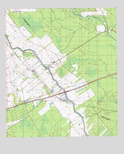
Grosse Tete, LA USGS Topographic Map
Click on map above to begin viewing in our Map Viewer.

This topographic map contains these locations and features:
Feature Name Type Latitude Longitude GNIS ID View Map
Agape Word ChurchChurchN30.4399°W91.4532°542843View Map
Bayou ChalpinStreamN30.4771°W91.3873°553431View Map
Bayou Cholpe Oil FieldOilfieldN30.4877°W91.4065°551004View Map
Bayou PoydrasStreamN30.4766°W91.3843°532744View Map
Bayou TommyStreamN30.4763°W91.3848°553533View Map
Cholpe BayouStreamN30.4930°W91.4054°553248View Map
Episcopal Church of the Nativity GraveCemeteryN30.4451°W91.4519°2776782View Map
Green LakeLakeN30.4090°W91.3769°554614View Map
Grosse TetePopulated PlaceN30.4110°W91.4337°558233View Map
Grosse Tete ChurchChurchN30.4094°W91.4293°557138View Map
Grosse Tete Gas FieldOilfieldN30.4180°W91.3876°551033View Map
Grosse Tete Post OfficePost OfficeN30.4139°W91.4334°1632107View Map
Grosse Tete Volunteer Fire DepartmentBuildingN30.4107°W91.4330°2691751View Map
Hartzell Church CemeteryCemeteryN30.4414°W91.4531°2776784View Map
Hartzell Methodist ChurchChurchN30.4416°W91.4523°558362View Map
Iberville Parish Library Grosse Tete BranchBuildingN30.4106°W91.4323°2603071View Map
Interchange 139CrossingN30.4185°W91.4340°541400View Map
King DitchCanalN30.3835°W91.4982°536201View Map
Levy SchoolSchoolN30.4485°W91.4446°558253View Map
Little House Preschool and Childcare Number 2SchoolN30.4226°W91.4391°2600117View Map
Maringouin Oil FieldOilfieldN30.4841°W91.4932°557156View Map
Mount Gideon Baptist CemeteryCemeteryN30.4566°W91.4929°2776787View Map
Mount Gideon ChurchChurchN30.4560°W91.4921°1629980View Map
Mount Spur CemeteryCemeteryN30.4612°W91.4894°557162View Map
Nativity ChurchChurchN30.4449°W91.4521°557197View Map
New Light Baptist CemeteryCemeteryN30.4132°W91.4326°2774718View Map
New Light Baptist ChurchChurchN30.4135°W91.4326°2602467View Map
New Mount Olive Baptist CemeteryCemeteryN30.4166°W91.4341°557204View Map
New Mount Olive ChurchChurchN30.4171°W91.4340°557166View Map
North Iberville Elementary and High SchoolSchoolN30.4581°W91.4783°558263View Map
Parish Governing Authority District 8CivilN30.4937°W91.3934°1934779View Map
Rose Hill CemeteryCemeteryN30.4562°W91.4691°2776788View Map
Rose Hill ChurchChurchN30.4571°W91.4682°538711View Map
RosedalePopulated PlaceN30.4413°W91.4521°558303View Map
Rosedale CemeteryCemeteryN30.4440°W91.4531°2776783View Map
Rosedale ChurchChurchN30.4427°W91.4548°557190View Map
Rosedale Methodist ChurchChurchN30.4380°W91.4504°558361View Map
Rosedale Oil and Gas FieldOilfieldN30.4205°W91.4571°557191View Map
Rosedale Volunteer Fire DepartmentBuildingN30.4415°W91.4526°2332403View Map
Saint Joseph CemeteryCemeteryN30.3824°W91.4143°538907View Map
Saint Josephs Catholic ChurchChurchN30.4160°W91.4337°557205View Map
Shady Grove High SchoolSchoolN30.4585°W91.4790°1629780View Map
Shady Grove Plantation (historical)LocaleN30.4571°W91.4793°557212View Map
Shell Memorial CemeteryCemeteryN30.4157°W91.4334°2774719View Map
SlacksPopulated PlaceN30.4657°W91.4934°543672View Map
Stumpy BayouStreamN30.4749°W91.3848°539705View Map
Sunnyside Apostolic ChurchChurchN30.4263°W91.4426°542844View Map
Sunnyside Plantation (historical)LocaleN30.4599°W91.4798°557215View Map
Village of Grosse TeteCivilN30.4157°W91.4376°2407471View Map
Village of RosedaleCivilN30.4429°W91.4601°2407539View Map
Ward SevenCivilN30.4152°W91.4623°545054View Map
WebrePopulated PlaceN30.4185°W91.4471°541209View Map

Note: Coordinates in the location and feature list above are referenced to NAD83 datum.


Copyright (C) 2008-2025 Ryan Niemi / Sunset Dynamics ... All Rights Reserved