TopoQuest Logo
Do you find TopoQuest useful?
Help keep TopoQuest running and adding new maps/features by donating!
Bitcoin:  19c7KJd3qBynnjoSw5npx9KScwjBe4ifkT
Litecoin:  LXs6TkuXGGXo1vDsWCkWVdjQX94eUKd6ui
Home View Maps Find Maps Find Places Resources & Links


Bolivar, Ohio Topographic Map

USGS Map Title: Bolivar, OH
USGS Map MRC: 40081F4
DRG (GeoTIFF) Download: o40081f4.tif


Neighboring USGS Topographic Map Quads:


  Massillon, OH  
40081G5
 

  Canton West, OH  
40081G4
 

  Canton East, OH  
40081G3
 

  Navarre, OH  
40081F5
 

  Bolivar, OH  
40081F4
 

  Waynesburg, OH  
40081F3
 

  Strasburg, OH  
40081E5
 

  Dover, OH  
40081E4
 

  Mineral City, OH  
40081E3


Map MRC Location:

N41°
W82°
N41°
W81°
H8 H7 H6 H5 H4 H3 H2 H1
G8 G7 G6 G5 G4 G3 G2 G1
F8 F7 F6 F5 F4 F3 F2 F1
E8 E7 E6 E5 E4 E3 E2 E1
D8 D7 D6 D5 D4 D3 D2 D1
C8 C7 C6 C5 C4 C3 C2 C1
B8 B7 B6 B5 B4 B3 B2 B1
A8 A7 A6 A5 A4 A3 A2 A1
N40°
W82°
N40°
W81°

Bolivar, OH USGS 1:24K Topographic Map Preview:
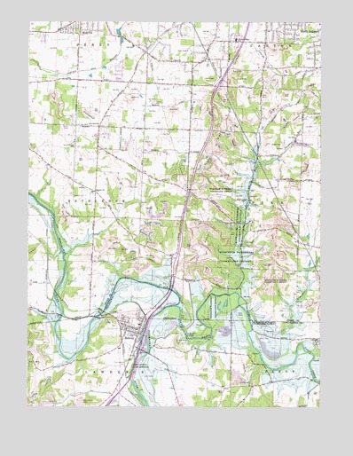
Bolivar, OH USGS Topographic Map
Click on map above to begin viewing in our Map Viewer.

This topographic map contains these locations and features:
Feature Name Type Latitude Longitude GNIS ID View Map
Anstine Vogley OrchardLocaleN40.7231°W81.4614°2544516View Map
Barto School (historical)SchoolN40.7112°W81.4512°1057573View Map
Battlesburg CemeteryCemeteryN40.6986°W81.3837°1037683View Map
Beal RunStreamN40.6623°W81.4112°1037708View Map
Bear RunStreamN40.6623°W81.4112°1066340View Map
Bixler (historical)Populated PlaceN40.6667°W81.4912°1057580View Map
BolivarPopulated PlaceN40.6501°W81.4521°1064463View Map
Bolivar DamDamN40.6488°W81.4324°1083971View Map
Bolivar Elementary SchoolSchoolN40.6517°W81.4521°1054237View Map
Bolivar LakeReservoirN40.6487°W81.4326°1077628View Map
Bolivar Police DepartmentBuildingN40.6498°W81.4511°2732704View Map
Bolivar Post OfficePost OfficeN40.6501°W81.4526°2062066View Map
Bolivar United Methodist ChurchChurchN40.6506°W81.4548°1961118View Map
Bolivar Volunteer Fire DepartmentBuildingN40.6501°W81.4594°2549821View Map
Briggs Airport (historical)AirportN40.7112°W81.3971°1082543View Map
Camp Zion ChurchChurchN40.6848°W81.4107°1048315View Map
Canton Mobile HomesPopulated PlaceN40.7258°W81.4064°2554305View Map
Church of God CemeteryCemeteryN40.7098°W81.4804°1039108View Map
Countywide Recycling and Disposal FacilityLocaleN40.6756°W81.4261°2678521View Map
East Sparta Volunteer Fire Department Station 2BuildingN40.7149°W81.4015°2549056View Map
Eden CemeteryCemeteryN40.7376°W81.4387°1730872View Map
Eden ChurchChurchN40.7376°W81.4387°1061048View Map
Faircrest Memorial Middle SchoolSchoolN40.7492°W81.3832°1057554View Map
Five Point ChurchChurchN40.7162°W81.4704°1040479View Map
Fohl VillagePopulated PlaceN40.7258°W81.4061°2547749View Map
Fort Laurens (historical)MilitaryN40.6372°W81.4564°1680828View Map
Fort Laurens CemeteryCemeteryN40.6398°W81.4576°1040587View Map
Fort Laurens State MemorialParkN40.6370°W81.4562°1061075View Map
Gerber CemeteryCemeteryN40.7370°W81.4268°1730873View Map
Grove CemeteryCemeteryN40.6924°W81.4106°1041199View Map
Grove ChurchChurchN40.6934°W81.4054°1061117View Map
Guest School (historical)SchoolN40.7148°W81.4101°1057555View Map
Henline CemeteryCemeteryN40.6634°W81.4134°1730875View Map
Interchange 99CrossingN40.7292°W81.4187°1057572View Map
Interchange l93CrossingN40.6440°W81.4521°1054266View Map
Knights CrossingPopulated PlaceN40.7452°W81.4901°2778052View Map
Lake AndreadisLakeN40.7468°W81.4616°2630714View Map
Lake ShermanLakeN40.7078°W81.4562°1046200View Map
Lake Sherman VillagePopulated PlaceN40.7081°W81.4528°2547746View Map
Lawrenceville (historical)Populated PlaceN40.6501°W81.4443°1067242View Map
Limestone CreekStreamN40.6553°W81.4059°1042572View Map
Little Brick School (historical)SchoolN40.6331°W81.3951°1054269View Map
Lohr SchoolSchoolN40.7420°W81.4557°1042721View Map
Mount Hope School (historical)SchoolN40.6945°W81.4804°1057579View Map
Mount Pleasant School (historical)SchoolN40.7162°W81.4801°1057578View Map
North Industry Sportsmans Club DamDamN40.6984°W81.4548°1078017View Map
North Industry Sportsmans Club LakeReservoirN40.6979°W81.4562°1078018View Map
North Industry Sportsmen ClubLocaleN40.6987°W81.4548°1057574View Map
Oak Grove School (historical)SchoolN40.6937°W81.4140°1068276View Map
Prairie College Elementary SchoolSchoolN40.7445°W81.4115°1081778View Map
Richville Station (historical)LocaleN40.7453°W81.4610°1057577View Map
Saint John United Church of ChristChurchN40.6459°W81.4537°1961121View Map
Saint Pauls Evangelical Lutheran ChurchChurchN40.6501°W81.4535°1961122View Map
Saint Stephens CemeteryCemeteryN40.6484°W81.4565°1054300View Map
Salem Church (historical)ChurchN40.6953°W81.4321°1057576View Map
Sandy CreekStreamN40.6578°W81.4373°1066944View Map
Scheipler School (historical)SchoolN40.7420°W81.4482°1057571View Map
Shepler CemeteryCemeteryN40.6934°W81.4807°1046187View Map
Shepler ChurchChurchN40.6951°W81.4715°1058013View Map
Sherman CemeteryCemeteryN40.6961°W81.4325°1046195View Map
Siffert CemeteryCemeteryN40.7151°W81.4296°1046262View Map
Springwood Lake CampLocaleN40.7014°W81.4362°1057575View Map
Studer CreekStreamN40.6525°W81.4875°2118241View Map
Sulphur RunStreamN40.7031°W81.4026°1046854View Map
Township of BethlehemCivilN40.6919°W81.4941°1086973View Map
Village of BolivarCivilN40.6506°W81.4555°2398148View Map
WHBC-AM (Canton)TowerN40.7209°W81.4410°1085260View Map
Wilkshire Golf CourseLocaleN40.6351°W81.4479°1054345View Map
Wilkshire HillsPopulated PlaceN40.6256°W81.4348°1054346View Map
Zion CemeteryCemeteryN40.6848°W81.4104°1730888View Map
Zutavern CemeteryCemeteryN40.6261°W81.4873°1048296View Map

Note: Coordinates in the location and feature list above are referenced to NAD83 datum.


Copyright (C) 2008-2024 Ryan Niemi / Sunset Dynamics ... All Rights Reserved