TopoQuest Logo
Do you find TopoQuest useful?
Help keep TopoQuest running and adding new maps/features by donating!
Bitcoin:  19c7KJd3qBynnjoSw5npx9KScwjBe4ifkT
Litecoin:  LXs6TkuXGGXo1vDsWCkWVdjQX94eUKd6ui
Home View Maps Find Maps Find Places Resources & Links


Warm Springs, Montana Topographic Map

USGS Map Title: Warm Springs, MT
USGS Map MRC: 46112B7
DRG (GeoTIFF) Download: o46112b7.tif


Neighboring USGS Topographic Map Quads:


  Mount Powell, MT  
46112C8
 

  Racetrack, MT  
46112C7
 

  Orofino Creek, MT  
46112C6
 

  Anaconda North, MT  
46112B8
 

  Warm Springs, MT  
46112B7
 

  Orofino Mountain, MT  
46112B6
 

  Anaconda South, MT  
46112A8
 

  Opportunity, MT  
46112A7
 

  Ramsay, MT  
46112A6


Map MRC Location:

N47°
W113°
N47°
W112°
H8 H7 H6 H5 H4 H3 H2 H1
G8 G7 G6 G5 G4 G3 G2 G1
F8 F7 F6 F5 F4 F3 F2 F1
E8 E7 E6 E5 E4 E3 E2 E1
D8 D7 D6 D5 D4 D3 D2 D1
C8 C7 C6 C5 C4 C3 C2 C1
B8 B7 B6 B5 B4 B3 B2 B1
A8 A7 A6 A5 A4 A3 A2 A1
N46°
W113°
N46°
W112°

Warm Springs, MT USGS 1:24K Topographic Map Preview:
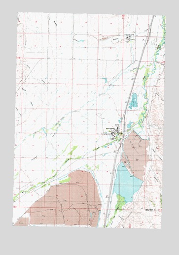
Warm Springs, MT USGS Topographic Map
Click on map above to begin viewing in our Map Viewer.

This topographic map contains these locations and features:
Feature Name Type Latitude Longitude GNIS ID View Map
04N10W05AACC01 WellWellN46.1341°W112.8653°814153View Map
04N10W05AACC02 WellWellN46.1341°W112.8653°814154View Map
04N10W05AB__01 WellWellN46.1335°W112.8684°814150View Map
05N09W05BA__01 WellWellN46.2210°W112.7575°814651View Map
05N09W05CDAD01 WellWellN46.2105°W112.7564°814602View Map
05N09W05CDBB01 WellWellN46.2116°W112.7598°814607View Map
05N09W05CDDD01 WellWellN46.2096°W112.7561°814599View Map
05N09W07CAAC01 WellWellN46.2005°W112.7778°814550View Map
05N09W07CB__01 WellWellN46.1994°W112.7836°814548View Map
05N09W07DABC01 WellWellN46.1999°W112.7700°814549View Map
05N09W07DCCC01 WellWellN46.1946°W112.7750°814518View Map
05N09W07DCDC01 WellWellN46.1946°W112.7725°814517View Map
05N09W08BCAB01 WellWellN46.2041°W112.7617°814573View Map
05N09W17BC__01 WellWellN46.1885°W112.7628°814490View Map
05N09W17BCCA01 WellWellN46.1883°W112.7642°814487View Map
05N09W17BCDB01 WellWellN46.1883°W112.7620°814486View Map
05N09W17BCDC01 WellWellN46.1871°W112.7623°814482View Map
05N09W17CACA01 WellWellN46.1852°W112.7606°814472View Map
05N09W18AB__01 WellWellN46.1921°W112.7734°814506View Map
05N09W18ADCD01 WellWellN46.1877°W112.7692°814484View Map
05N09W18ADCD02 WellWellN46.1877°W112.7692°814485View Map
05N09W24ABAA01 WellWellN46.1785°W112.7928°814432View Map
05N09W29BC__01 WellWellN46.1599°W112.7628°814301View Map
05N10W02AA__01 WellWellN46.2208°W112.8100°814647View Map
05N10W02AAAB01 WellWellN46.2224°W112.8095°814656View Map
05N10W03AA__01 WellWellN46.2208°W112.8312°814648View Map
05N10W03BBBB01 WellWellN46.2227°W112.8492°814657View Map
05N10W03CB__01 WellWellN46.2135°W112.8470°814616View Map
05N10W03CBCC01 WellWellN46.2133°W112.8484°814615View Map
05N10W03DD__01 WellWellN46.2099°W112.8312°814600View Map
05N10W04AA__01 WellWellN46.2208°W112.8520°814649View Map
05N10W10CB__01 WellWellN46.1991°W112.8470°814544View Map
05N10W10CCBC01 WellWellN46.1971°W112.8484°814531View Map
05N10W13BC__01 WellWellN46.1883°W112.8050°814488View Map
05N10W13DA__01 WellWellN46.1846°W112.7892°814466View Map
05N10W14DC__01 WellWellN46.1810°W112.8153°814453View Map
05N10W15BA__01 WellWellN46.1919°W112.8417°814503View Map
05N10W16AC__01 WellWellN46.1883°W112.8573°814489View Map
05N10W16DC__01 WellWellN46.1810°W112.8573°814454View Map
05N10W22DD__01 WellWellN46.1663°W112.8311°814345View Map
05N10W23DC__01 WellWellN46.1663°W112.8153°814344View Map
05N10W23DD__01 WellWellN46.1663°W112.8100°814343View Map
05N10W23DDCD01 WellWellN46.1655°W112.8114°814340View Map
05N10W24AA__01 WellWellN46.1771°W112.7892°814424View Map
05N10W24ABBC01 SpringSpringN46.1777°W112.7959°814426View Map
05N10W24CB__01 WellWellN46.1699°W112.8050°814366View Map
05N10W24DA__01 WellWellN46.1699°W112.7892°814365View Map
05N10W25DA__01 WellWellN46.1555°W112.7892°814286View Map
05N10W27DADA01 WellWellN46.1560°W112.8292°814289View Map
05N10W27DCBD01 WellWellN46.1530°W112.8370°814270View Map
05N10W33AB__01 WellWellN46.1483°W112.8573°814244View Map
05N10W33BCCC01 WellWellN46.1430°W112.8692°814214View Map
05N10W33BCDB01 WellWellN46.1444°W112.8670°814219View Map
05N10W33DA__01 WellWellN46.1410°W112.8520°814197View Map
06N09W29AC__01 WellWellN46.2463°W112.7523°814767View Map
06N09W29BB__01 WellWellN46.2499°W112.7625°814790View Map
06N09W30AB__02 WellWellN46.2499°W112.7731°814791View Map
06N09W30CD__01 WellWellN46.2391°W112.7781°814734View Map
06N09W31BB__01 WellWellN46.2355°W112.7834°814719View Map
06N09W31CD__01 WellWellN46.2246°W112.7781°814667View Map
06N09W31CDAB01 WellWellN46.2269°W112.7786°814680View Map
06N09W31DD__01 WellWellN46.2246°W112.7678°814666View Map
06N10W26DC__01 WellWellN46.2410°W112.8162°814746View Map
06N10W27CCCC01 WellWellN46.2388°W112.8467°814731View Map
06N10W34AD__01 WellWellN46.2338°W112.8317°814711View Map
06N10W35AB__01 WellWellN46.2374°W112.8162°814722View Map
Babcock DamDamN46.2283°W112.8025°798740View Map
Beck DitchCanalN46.2158°W112.7861°779643View Map
Beckstead DitchCanalN46.2252°W112.7639°779644View Map
Bowman FieldAirportN46.1485°W112.8623°806352View Map
Cook CreekStreamN46.1821°W112.7681°781601View Map
Dry Cottonwood CreekStreamN46.2444°W112.7509°782550View Map
Dutchman CreekStreamN46.1946°W112.8217°782736View Map
Fifer-Cummock DitchCanalN46.2080°W112.8275°783376View Map
Fredrickson (historical)Populated PlaceN46.2383°W112.8259°1786406View Map
GalenPopulated PlaceN46.2355°W112.7761°783797View Map
Galen SpurLocaleN46.2277°W112.7703°783798View Map
Gardiner DitchCanalN46.2091°W112.8537°783831View Map
Girard GulchValleyN46.1846°W112.7606°783956View Map
Heapby Reservoir DamDamN46.2333°W112.8242°796506View Map
Homestead CreekStreamN46.1324°W112.7870°784976View Map
Interchange 197CrossingN46.2374°W112.7648°1786455View Map
Interchange 201CrossingN46.1816°W112.7836°1786457View Map
Jacobson DitchCanalN46.2174°W112.7867°785407View Map
Lost CreekStreamN46.2269°W112.7581°786582View Map
Mill-Willow BypassCanalN46.1838°W112.7698°793803View Map
Montana State HospitalHospitalN46.1808°W112.7909°792839View Map
Montana State Hospital Galen CampusHospitalN46.2355°W112.7811°793805View Map
Montana State Hospital Warm Springs CampusHospitalN46.1802°W112.7945°806244View Map
MorelPopulated PlaceN46.1505°W112.7678°787679View Map
Morel BridgeBridgeN46.1735°W112.7620°1786453View Map
Opportunity Tailings Ponds DamDamN46.1499°W112.8042°796533View Map
Perkins GulchValleyN46.2055°W112.7581°788763View Map
Prairie GulchValleyN46.2330°W112.8628°789172View Map
Reintegrating Youthful Offenders Juvenile Correctional FacilityBuildingN46.2348°W112.7775°2766784View Map
Ruby MineMineN46.1977°W112.8700°803333View Map
Sand CreekStreamN46.2233°W112.7578°789998View Map
Silver Bow CreekStreamN46.1869°W112.7718°790496View Map
Spring GulchValleyN46.2016°W112.8673°791301View Map
Warm SpringsLocaleN46.1813°W112.7848°1786357View Map
Warm SpringsPopulated PlaceN46.1813°W112.7848°806822View Map
Warm Springs Bridge Fishing Access SiteLocaleN46.1871°W112.7709°1744447View Map
Warm Springs CreekStreamN46.1869°W112.7718°792838View Map
Warm Springs Creek BridgeBridgeN46.1805°W112.7864°1786454View Map
Warm Springs DivisionCivilN46.1990°W112.7956°1940599View Map
Warm Springs Post OfficePost OfficeN46.1817°W112.7889°1786381View Map
Warm Springs School (historical)SchoolN46.1813°W112.7848°1786358View Map
Warm Springs State Wildlife Management AreaParkN46.1977°W112.7681°807084View Map
Warm Springs Tailing Dam Number 1DamN46.1816°W112.7742°796534View Map
Warm Springs Tailing Dam Number 2DamN46.1749°W112.7759°796536View Map
Warm Springs Tailing Dam Number 3DamN46.1583°W112.7759°796535View Map
Whitcraft GulchValleyN46.1596°W112.7609°793186View Map
Willow Glen School (historical)SchoolN46.1666°W112.8717°1786354View Map
Willowglen Post Office (historical)Post OfficeN46.1666°W112.8717°1786382View Map

Note: Coordinates in the location and feature list above are referenced to NAD83 datum.


Copyright (C) 2008-2025 Ryan Niemi / Sunset Dynamics ... All Rights Reserved