TopoQuest Logo
Do you find TopoQuest useful?
Help keep TopoQuest running and adding new maps/features by donating!
Bitcoin:  19c7KJd3qBynnjoSw5npx9KScwjBe4ifkT
Litecoin:  LXs6TkuXGGXo1vDsWCkWVdjQX94eUKd6ui
Home View Maps Find Maps Find Places Resources & Links


Washington Dome, Utah Topographic Map

USGS Map Title: Washington Dome, UT
USGS Map MRC: 37113A4
DRG (GeoTIFF) Download: o37113a4.tif


Neighboring USGS Topographic Map Quads:


  Washington, UT  
37113B5
 

  Harrisburg Junction, UT  
37113B4
 

  Hurricane, UT  
37113B3
 

  Saint George, UT  
37113A5
 

  Washington Dome, UT  
37113A4
 

  The Divide, UT  
37113A3
 

  Lizard Point, AZ  
36113H5
 

  Yellowhorse Flat, AZ  
36113H4
 

  Rock Canyon, AZ  
36113H3


Map MRC Location:

N38°
W114°
N38°
W113°
H8 H7 H6 H5 H4 H3 H2 H1
G8 G7 G6 G5 G4 G3 G2 G1
F8 F7 F6 F5 F4 F3 F2 F1
E8 E7 E6 E5 E4 E3 E2 E1
D8 D7 D6 D5 D4 D3 D2 D1
C8 C7 C6 C5 C4 C3 C2 C1
B8 B7 B6 B5 B4 B3 B2 B1
A8 A7 A6 A5 A4 A3 A2 A1
N37°
W114°
N37°
W113°

Washington Dome, UT USGS 1:24K Topographic Map Preview:
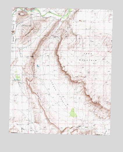
Washington Dome, UT USGS Topographic Map
Click on map above to begin viewing in our Map Viewer.

This topographic map contains these locations and features:
Feature Name Type Latitude Longitude GNIS ID View Map
Beehive DomeSummitN37.0114°W113.4669°1435110View Map
Dutchman DrawValleyN37.0058°W113.4858°4214View Map
Grapevine Pass WashValleyN37.1222°W113.4852°1428341View Map
Gypsum Wash Debris Basin DamDamN37.0800°W113.4891°1434610View Map
Gypsum Wash Debris Basin ReservoirReservoirN37.0797°W113.4887°1434609View Map
Herd HouseLocaleN37.0058°W113.4708°1428671View Map
Hurricane WashValleyN37.0050°W113.3805°1455331View Map
Little Black MountainSummitN37.0003°W113.4936°1429680View Map
Punchbowl DomeSummitN37.0783°W113.4719°1436179View Map
Saint George and Washington CanalCanalN37.1194°W113.4672°1432113View Map
Sand MountainSummitN37.0628°W113.3936°1432195View Map
Shinob KibeSummitN37.1172°W113.4880°1432407View Map
Stucki Debris Basin DamDamN37.0500°W113.4883°1434606View Map
Stucki Debris Basin ReservoirReservoirN37.0499°W113.4877°1434605View Map
Warner Draw Debris Basin DamDamN37.0583°W113.4691°1434608View Map
Warner Draw Debris Basin ReservoirReservoirN37.0583°W113.4691°1434607View Map
Warner RidgeRidgeN37.0775°W113.4722°1433966View Map
Warner ValleyBasinN37.0291°W113.4305°1433968View Map
Warner Valley SpringSpringN37.0958°W113.4472°1433969View Map
Washington City Fire Department - Station 62BuildingN37.1088°W113.4946°2768505View Map
Washington DomeSummitN37.1058°W113.4722°1436590View Map

Note: Coordinates in the location and feature list above are referenced to NAD83 datum.


Copyright (C) 2008-2025 Ryan Niemi / Sunset Dynamics ... All Rights Reserved