TopoQuest Logo
Do you find TopoQuest useful?
Help keep TopoQuest running and adding new maps/features by donating!
Bitcoin:  19c7KJd3qBynnjoSw5npx9KScwjBe4ifkT
Litecoin:  LXs6TkuXGGXo1vDsWCkWVdjQX94eUKd6ui
Home View Maps Find Maps Find Places Resources & Links


Washington, Utah Topographic Map

USGS Map Title: Washington, UT
USGS Map MRC: 37113B5
DRG (GeoTIFF) Download: o37113b5.tif


Neighboring USGS Topographic Map Quads:


  Veyo, UT  
37113C6
 

  Saddle Mountain, UT  
37113C5
 

  Signal Peak, UT  
37113C4
 

  Santa Clara, UT  
37113B6
 

  Washington, UT  
37113B5
 

  Harrisburg Junction, UT  
37113B4
 

  White Hills, UT  
37113A6
 

  Saint George, UT  
37113A5
 

  Washington Dome, UT  
37113A4


Map MRC Location:

N38°
W114°
N38°
W113°
H8 H7 H6 H5 H4 H3 H2 H1
G8 G7 G6 G5 G4 G3 G2 G1
F8 F7 F6 F5 F4 F3 F2 F1
E8 E7 E6 E5 E4 E3 E2 E1
D8 D7 D6 D5 D4 D3 D2 D1
C8 C7 C6 C5 C4 C3 C2 C1
B8 B7 B6 B5 B4 B3 B2 B1
A8 A7 A6 A5 A4 A3 A2 A1
N37°
W114°
N37°
W113°

Washington, UT USGS 1:24K Topographic Map Preview:
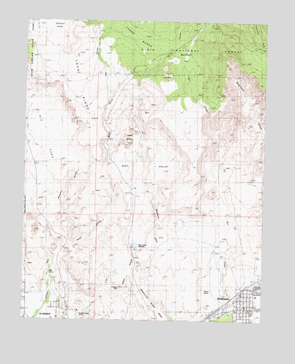
Washington, UT USGS Topographic Map
Click on map above to begin viewing in our Map Viewer.

This topographic map contains these locations and features:
Feature Name Type Latitude Longitude GNIS ID View Map
Alger HollowValleyN37.2180°W113.5841°1438152View Map
Big SandFlatN37.1975°W113.6238°1438728View Map
Black GulchValleyN37.1819°W113.5819°1438844View Map
Black KnollsSummitN37.1505°W113.5666°1425680View Map
Black Knolls ReservoirReservoirN37.1561°W113.5688°1438854View Map
Buckskin HollowValleyN37.1561°W113.6058°1439252View Map
Cedar BenchBenchN37.2422°W113.5708°1439553View Map
Cottonwood Guard StationLocaleN37.2380°W113.5422°1440023View Map
East ValleyValleyN37.1819°W113.5611°1440853View Map
Gold Cross AmbulanceBuildingN37.1253°W113.6044°2768458View Map
Grace Baptist ChurchChurchN37.1311°W113.5436°1455605View Map
Gray SpringSpringN37.1455°W113.6236°1441456View Map
Green SpringSpringN37.1383°W113.5286°1441478View Map
KCLG-AM (Washington)TowerN37.1439°W113.5016°1455725View Map
Lava RidgeRidgeN37.2250°W113.5972°1442454View Map
Middleton Black RidgeRidgeN37.1264°W113.5552°1443381View Map
Miller SpringSpringN37.1422°W113.6111°1443492View Map
Old Alexander CemeteryCemeteryN37.1370°W113.5069°2769309View Map
Redlands RV ParksParkN37.1291°W113.5202°1448907View Map
Saint George Fire Department Station 7BuildingN37.1398°W113.6246°2627252View Map
Sait George City DamDamN37.1555°W113.5686°1447618View Map
Santa Clara DamDamN37.1300°W113.5541°1447616View Map
Santa Clara ReservoirReservoirN37.1300°W113.5541°1447615View Map
Spring HollowValleyN37.2333°W113.5552°1446045View Map
T-Bone HillSummitN37.1383°W113.5755°1449090View Map
The Church of Jesus Christ of Latter Day SaintsChurchN37.1311°W113.5094°1455679View Map
Twin PeaksSummitN37.2278°W113.5544°1446793View Map
Twist HollowValleyN37.1533°W113.6111°1446813View Map
WashingtonPopulated PlaceN37.1305°W113.5083°1447019View Map
Washington City CemeteryCemeteryN37.1319°W113.5038°1449162View Map
Washington City Fire Department - Station 61BuildingN37.1399°W113.5134°2627367View Map
Washington City Police DepartmentBuildingN37.1318°W113.5090°2730443View Map
Washington Elementary SchoolSchoolN37.1357°W113.5041°1449163View Map
Washington FlatFlatN37.2333°W113.5361°1447020View Map
Washington HollowValleyN37.1847°W113.5200°1447023View Map
Washington Post OfficePost OfficeN37.1300°W113.5104°1455572View Map
West Saint George SpringSpringN37.1275°W113.5958°1447174View Map
Winchester Hills Volunteer Fire DepartmentBuildingN37.2115°W113.6088°2627267View Map
Yellow KnollsSummitN37.2033°W113.5802°1447554View Map

Note: Coordinates in the location and feature list above are referenced to NAD83 datum.


Copyright (C) 2008-2025 Ryan Niemi / Sunset Dynamics ... All Rights Reserved