TopoQuest Logo
Do you find TopoQuest useful?
Help keep TopoQuest running and adding new maps/features by donating!
Bitcoin:  19c7KJd3qBynnjoSw5npx9KScwjBe4ifkT
Litecoin:  LXs6TkuXGGXo1vDsWCkWVdjQX94eUKd6ui
Home View Maps Find Maps Find Places Resources & Links


Washington Island NW, Wisconsin Topographic Map

USGS Map Title: Washington Island NW, WI
USGS Map MRC: 45086D8
DRG (GeoTIFF) Download: o45086d8.tif


Neighboring USGS Topographic Map Quads:


  Washington Island NW, WI  
45086D8
 

  Washington Island NE, WI  
45086D7
 

  Ellison Bay, WI  
45087C1
 

  Washington Island SW, WI  
45086C8
 

  Washington Island SE, WI  
45086C7


Map MRC Location:

N46°
W87°
N46°
W86°
H8 H7 H6 H5 H4 H3 H2 H1
G8 G7 G6 G5 G4 G3 G2 G1
F8 F7 F6 F5 F4 F3 F2 F1
E8 E7 E6 E5 E4 E3 E2 E1
D8 D7 D6 D5 D4 D3 D2 D1
C8 C7 C6 C5 C4 C3 C2 C1
B8 B7 B6 B5 B4 B3 B2 B1
A8 A7 A6 A5 A4 A3 A2 A1
N45°
W87°
N45°
W86°

Washington Island NW, WI USGS 1:24K Topographic Map Preview:
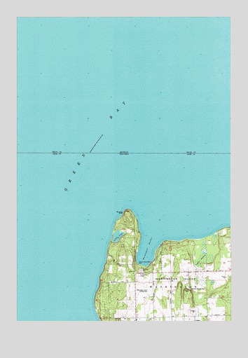
Washington Island NW, WI USGS Topographic Map
Click on map above to begin viewing in our Map Viewer.

This topographic map contains these locations and features:
Feature Name Type Latitude Longitude GNIS ID View Map
Bethel ChurchChurchN45.3955°W86.9315°1581468View Map
Bethel Evangelical Free ChurchChurchN45.3955°W86.9315°1578004View Map
Bowyer BluffCliffN45.4200°W86.9360°1577244View Map
Boyer Bluff LightBuildingN45.4200°W86.9365°1578005View Map
Coffee SwampSwampN45.4008°W86.8904°1563229View Map
Coffey Swamp State Natural AreaParkN45.4033°W86.8872°2085419View Map
Island CemeteryCemeteryN45.3961°W86.9278°1578003View Map
Little LakeLakeN45.4100°W86.9413°1568302View Map
Mountain Wayside ParkParkN45.3883°W86.8990°1578001View Map
Saint Michaels ChapelChurchN45.3944°W86.9279°1577999View Map
School House Beach ParkParkN45.3972°W86.9257°1578006View Map
Trinity Evangelical Lutheran ChurchChurchN45.3761°W86.9246°1575634View Map
WashingtonPopulated PlaceN45.3947°W86.9315°1576235View Map
Washington HarborBayN45.4066°W86.9232°1576241View Map
Washington IslandIslandN45.3772°W86.9010°1576244View Map
Washington Island AirportAirportN45.3851°W86.9229°1582251View Map
Washington Island Farm MuseumBuildingN45.3944°W86.9201°1838085View Map
Washington Island LandfillLocaleN45.3861°W86.8842°2635475View Map
Washington Island Volunteer Fire DepartmentBuildingN45.3760°W86.9206°2697934View Map

Note: Coordinates in the location and feature list above are referenced to NAD83 datum.


Copyright (C) 2008-2024 Ryan Niemi / Sunset Dynamics ... All Rights Reserved