TopoQuest Logo
Do you find TopoQuest useful?
Help keep TopoQuest running and adding new maps/features by donating!
Bitcoin:  19c7KJd3qBynnjoSw5npx9KScwjBe4ifkT
Litecoin:  LXs6TkuXGGXo1vDsWCkWVdjQX94eUKd6ui
Home View Maps Find Maps Find Places Resources & Links


Washington Island SW, Wisconsin Topographic Map

USGS Map Title: Washington Island SW, WI
USGS Map MRC: 45086C8
DRG (GeoTIFF) Download: o45086c8.tif


Neighboring USGS Topographic Map Quads:


  Washington Island NW, WI  
45086D8
 

  Washington Island NE, WI  
45086D7
 

  Ellison Bay, WI  
45087C1
 

  Washington Island SW, WI  
45086C8
 

  Washington Island SE, WI  
45086C7
 

  Sister Bay, WI  
45087B1
 

  Spider Island, WI  
45086B8


Map MRC Location:

N46°
W87°
N46°
W86°
H8 H7 H6 H5 H4 H3 H2 H1
G8 G7 G6 G5 G4 G3 G2 G1
F8 F7 F6 F5 F4 F3 F2 F1
E8 E7 E6 E5 E4 E3 E2 E1
D8 D7 D6 D5 D4 D3 D2 D1
C8 C7 C6 C5 C4 C3 C2 C1
B8 B7 B6 B5 B4 B3 B2 B1
A8 A7 A6 A5 A4 A3 A2 A1
N45°
W87°
N45°
W86°

Washington Island SW, WI USGS 1:24K Topographic Map Preview:
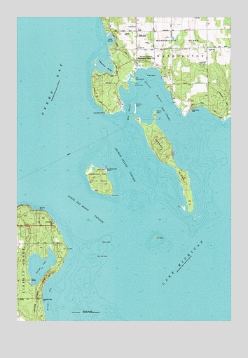
Washington Island SW, WI USGS Topographic Map
Click on map above to begin viewing in our Map Viewer.

This topographic map contains these locations and features:
Feature Name Type Latitude Longitude GNIS ID View Map
Big Susie IslandIslandN45.3492°W86.9323°1578007View Map
Detroit HarborBayN45.3467°W86.9240°1563919View Map
Detroit HarborPopulated PlaceN45.3567°W86.9307°1584512View Map
Detroit Harbor State Natural AreaParkN45.3500°W86.9350°2085420View Map
Detroit IslandIslandN45.3167°W86.9107°1563920View Map
Detroit Island PassageChannelN45.3189°W86.9390°1563921View Map
Door County Library Washington Island BranchBuildingN45.3622°W86.9297°2711361View Map
East ChannelCanalN45.3355°W86.9132°1578015View Map
Europe BayBayN45.2536°W86.9796°1564714View Map
Europe Bay Woods State Natural AreaParkN45.2653°W86.9861°2085422View Map
Europe LakeLakeN45.2726°W86.9864°1564715View Map
Ferdinand Hotz ParkParkN45.2586°W86.9868°1564915View Map
Figenscaus HarborBayN45.3558°W86.9501°1576512View Map
Gislason BeachBeachN45.3386°W86.9071°1838054View Map
Gravel IslandIslandN45.2536°W86.9629°1565781View Map
Kenosha ParkParkN45.2953°W86.9879°1567417View Map
Little Susie IslandIslandN45.3475°W86.9326°1577915View Map
Lobdells PointCapeN45.3358°W86.9479°1568476View Map
Maple Grove Golf CourseLocaleN45.3683°W86.9287°1578009View Map
Middle ShoalBarN45.3167°W86.9362°1577223View Map
Nine Foot ShoalBarN45.2764°W86.9559°1570295View Map
NorthportPopulated PlaceN45.2919°W86.9801°1570530View Map
Pedersens BayBayN45.3342°W86.9248°1838063View Map
Pilot IslandIslandN45.2850°W86.9198°1571410View Map
Pilot Island LightBuildingN45.2844°W86.9193°1578016View Map
Plum IslandIslandN45.3072°W86.9518°1571697View Map
Plum Light Range LightsBuildingN45.3078°W86.9579°1578017View Map
Porte des MortsChannelN45.2933°W86.9587°1581567View Map
Rabbit PointCapeN45.3358°W86.9193°1578014View Map
Richters PointCapeN45.3383°W86.9310°1578010View Map
Rocky Ridge FarmLocaleN45.3717°W86.9047°2711363View Map
Sand Dunes ParkParkN45.3372°W86.8973°1578012View Map
Shipyard Island Marina-Multiple Lifting FacilitiesHarborN45.3397°W86.9085°1578013View Map
Snake IslandIslandN45.3505°W86.9243°1578008View Map
Washington Island Elementary SchoolSchoolN45.3614°W86.9286°1838084View Map
Washington Island Police DepartmentBuildingN45.3670°W86.9307°2759725View Map
Washington Island SchoolSchoolN45.3613°W86.9286°1838086View Map
Waverly ShoalBarN45.2819°W86.9518°1576342View Map
West ChannelCanalN45.3350°W86.9357°1578011View Map
West HarborBayN45.3658°W86.9454°1577218View Map
Windflower FarmLocaleN45.3558°W86.9106°2711362View Map

Note: Coordinates in the location and feature list above are referenced to NAD83 datum.


Copyright (C) 2008-2025 Ryan Niemi / Sunset Dynamics ... All Rights Reserved