TopoQuest Logo
Do you find TopoQuest useful?
Help keep TopoQuest running and adding new maps/features by donating!
Bitcoin:  19c7KJd3qBynnjoSw5npx9KScwjBe4ifkT
Litecoin:  LXs6TkuXGGXo1vDsWCkWVdjQX94eUKd6ui
Home View Maps Find Maps Find Places Resources & Links


Waterview, Kentucky Topographic Map

USGS Map Title: Waterview, KY
USGS Map MRC: 36085G4
DRG (GeoTIFF) Download: o36085g4.tif


Neighboring USGS Topographic Map Quads:


  Edmonton, KY  
36085H5
 

  Breeding, KY  
36085H4
 

  Amandaville, KY  
36085H3
 

  Dubre, KY  
36085G5
 

  Waterview, KY  
36085G4
 

  Burkesville, KY  
36085G3
 

  Vernon, KY  
36085F5
 

  Blacks Ferry, KY  
36085F4
 

  Frogue, KY  
36085F3


Map MRC Location:

N37°
W86°
N37°
W85°
H8 H7 H6 H5 H4 H3 H2 H1
G8 G7 G6 G5 G4 G3 G2 G1
F8 F7 F6 F5 F4 F3 F2 F1
E8 E7 E6 E5 E4 E3 E2 E1
D8 D7 D6 D5 D4 D3 D2 D1
C8 C7 C6 C5 C4 C3 C2 C1
B8 B7 B6 B5 B4 B3 B2 B1
A8 A7 A6 A5 A4 A3 A2 A1
N36°
W86°
N36°
W85°

Waterview, KY USGS 1:24K Topographic Map Preview:
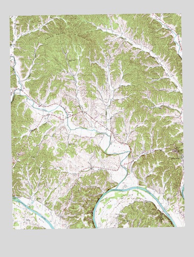
Waterview, KY USGS Topographic Map
Click on map above to begin viewing in our Map Viewer.

This topographic map contains these locations and features:
Feature Name Type Latitude Longitude GNIS ID View Map
Allen CreekStreamN36.8051°W85.4300°485867View Map
AratPopulated PlaceN36.7567°W85.4652°507408View Map
Baise ChapelChurchN36.8201°W85.3925°486233View Map
Beech Grove SchoolSchoolN36.8001°W85.4583°486734View Map
Big RenoxPopulated PlaceN36.8715°W85.3901°2742607View Map
Bombshell CreekStreamN36.8606°W85.4964°487649View Map
Branham CemeteryCemeteryN36.7912°W85.4830°487831View Map
Bull RidgeRidgeN36.7620°W85.4489°488358View Map
Burkesville DivisionCivilN36.8429°W85.4255°1936899View Map
Carter BranchStreamN36.7637°W85.4886°488991View Map
Carter BranchStreamN36.8442°W85.3910°2742609View Map
Casey ForkPopulated PlaceN36.8575°W85.4995°2742610View Map
Casey ForkStreamN36.8314°W85.4925°489048View Map
Casey Fork SchoolSchoolN36.8578°W85.4997°489050View Map
Cloyds LandingPopulated PlaceN36.7542°W85.4911°507720View Map
Cloyds Landing IslandIslandN36.7681°W85.4977°489713View Map
Cumberland CountyCivilN36.7865°W85.3884°516875View Map
Cumberland OverlookLocaleN36.7937°W85.3775°490479View Map
Dug Road HollowValleyN36.8374°W85.3850°491264View Map
Dutch CreekStreamN36.8076°W85.4395°491357View Map
Dutch Creek ChurchChurchN36.8362°W85.4526°491359View Map
EllingtonPopulated PlaceN36.7573°W85.4230°507927View Map
Ellington CemeteryCemeteryN36.7664°W85.4216°491700View Map
Franklin BranchStreamN36.8359°W85.4930°492444View Map
German BranchStreamN36.8186°W85.4724°492793View Map
GriderPopulated PlaceN36.8042°W85.4255°493373View Map
Haggard BranchStreamN36.7726°W85.4189°493542View Map
LesliePopulated PlaceN36.7795°W85.4519°508447View Map
Leslie BranchStreamN36.7759°W85.4222°496291View Map
Leslie SchoolSchoolN36.7853°W85.4414°496293View Map
Lions BranchStreamN36.7508°W85.4703°2742618View Map
Little Renox (historical)Populated PlaceN36.8483°W85.3918°2742619View Map
Little Renox SchoolSchoolN36.8481°W85.3922°496835View Map
Marrowbone CreekStreamN36.7728°W85.4241°497560View Map
Mount Hope ChurchChurchN36.7673°W85.4825°498755View Map
Newby CemeteryCemeteryN36.7653°W85.4025°499422View Map
Norris ForkStreamN36.7946°W85.4158°2742622View Map
North HollowValleyN36.7708°W85.4842°499574View Map
Oliver FerryCrossingN36.7601°W85.3897°499932View Map
Pleasant Hill SchoolSchoolN36.7542°W85.4155°500876View Map
Pumpkin HollowValleyN36.8496°W85.4993°501432View Map
Purgatory HollowValleyN36.8297°W85.3779°501465View Map
Rocky Point RidgeRidgeN36.8631°W85.4625°502259View Map
Shaddoan BranchStreamN36.8617°W85.4193°2742625View Map
Strange BranchStreamN36.8703°W85.3908°504565View Map
Sugar Grove (historical)Populated PlaceN36.8598°W85.4165°2742626View Map
Sugar Grove SchoolSchoolN36.8598°W85.4155°504668View Map
WaterviewPopulated PlaceN36.8170°W85.4583°506269View Map
Whites BottomBendN36.7687°W85.4252°506664View Map
WKYR-FM (Burkesville)TowerN36.7906°W85.3797°517929View Map
Yellow BranchStreamN36.7502°W85.4383°2742628View Map
Youngs SchoolSchoolN36.7645°W85.4758°507258View Map

Note: Coordinates in the location and feature list above are referenced to NAD83 datum.


Copyright (C) 2008-2024 Ryan Niemi / Sunset Dynamics ... All Rights Reserved