TopoQuest Logo
Do you find TopoQuest useful?
Help keep TopoQuest running and adding new maps/features by donating!
Bitcoin:  19c7KJd3qBynnjoSw5npx9KScwjBe4ifkT
Litecoin:  LXs6TkuXGGXo1vDsWCkWVdjQX94eUKd6ui
Home View Maps Find Maps Find Places Resources & Links


Waterville, Iowa Topographic Map

USGS Map Title: Waterville, IA
USGS Map MRC: 43091B3
DRG (GeoTIFF) Download: o43091b3.tif


Neighboring USGS Topographic Map Quads:


  Waukon, IA  
43091C4
 

  Church, IA  
43091C3
 

  Lansing, IA  
43091C2
 

  Rossville, IA  
43091B4
 

  Waterville, IA  
43091B3
 

  Harpers Ferry, IA  
43091B2
 

  Monona, IA  
43091A4
 

  Giard, IA  
43091A3
 

  Prairie du Chien, WI  
43091A2


Map MRC Location:

N44°
W92°
N44°
W91°
H8 H7 H6 H5 H4 H3 H2 H1
G8 G7 G6 G5 G4 G3 G2 G1
F8 F7 F6 F5 F4 F3 F2 F1
E8 E7 E6 E5 E4 E3 E2 E1
D8 D7 D6 D5 D4 D3 D2 D1
C8 C7 C6 C5 C4 C3 C2 C1
B8 B7 B6 B5 B4 B3 B2 B1
A8 A7 A6 A5 A4 A3 A2 A1
N43°
W92°
N43°
W91°

Waterville, IA USGS 1:24K Topographic Map Preview:
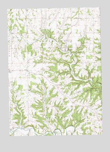
Waterville, IA USGS Topographic Map
Click on map above to begin viewing in our Map Viewer.

This topographic map contains these locations and features:
Feature Name Type Latitude Longitude GNIS ID View Map
Bridge Sixteen Canoe AccessLocaleN43.1278°W91.3140°1948774View Map
Buckland Post Office (historical)Post OfficeN43.1255°W91.3140°1948823View Map
Cherry Mound CemeteryCemeteryN43.1669°W91.2794°1948963View Map
City of WatervilleCivilN43.2083°W91.2960°2397213View Map
Dry Hollow CreekStreamN43.1275°W91.3224°456027View Map
East Paint Creek ChurchChurchN43.2391°W91.2785°456186View Map
East Paint Creek Synod CemeteryCemeteryN43.2393°W91.2789°1948967View Map
EganPopulated PlaceN43.1566°W91.2896°464531View Map
Egan Post Office (historical)Post OfficeN43.1566°W91.2896°1948815View Map
Independent Order of Odd Fellows CemeteryCemeteryN43.1782°W91.3736°457740View Map
Maple Hill CemeteryCemeteryN43.1707°W91.3472°1948965View Map
MaudPopulated PlaceN43.2264°W91.3704°464646View Map
Maud Post Office (historical)Post OfficeN43.2264°W91.3704°1948802View Map
Monsrud BridgeBridgeN43.2191°W91.3265°1948968View Map
Paintville Post Office (historical)Post OfficeN43.2166°W91.3529°1948800View Map
Rossville ParkParkN43.1891°W91.3496°1948858View Map
Saint Pius ChurchChurchN43.1672°W91.2804°461331View Map
SixteenPopulated PlaceN43.1266°W91.3160°464748View Map
Sixteen CemeteryCemeteryN43.1274°W91.3128°1948964View Map
Suttle CreekStreamN43.1316°W91.3476°462126View Map
Township of LintonCivilN43.1278°W91.3170°468284View Map
Township of Paint CreekCivilN43.2109°W91.3104°468493View Map
VolneyPopulated PlaceN43.1305°W91.3737°462592View Map
Volney Post Office (historical)Post OfficeN43.1305°W91.3737°1948803View Map
WatervillePopulated PlaceN43.2078°W91.2976°462734View Map
Waterville (historical)LocaleN43.2078°W91.2976°1948829View Map
Waterville Ambulance ServiceBuildingN43.2094°W91.2974°2599791View Map
Waterville Elementary SchoolSchoolN43.2128°W91.2976°1948833View Map
Waterville FarmParkN43.2005°W91.2862°1948775View Map
Waterville Fire DepartmentBuildingN43.2094°W91.2974°2577265View Map
Waterville Lutheran CemeteryCemeteryN43.2108°W91.2960°1948966View Map
Waterville Lutheran ChurchChurchN43.2105°W91.2976°1948834View Map
Waterville Pines ParkParkN43.2069°W91.2871°1948776View Map
Waterville Post OfficePost OfficeN43.2078°W91.2976°1948831View Map
Waterville Public LibraryBuildingN43.2078°W91.2976°1948832View Map
Waterville Town HallBuildingN43.2078°W91.2976°1948830View Map

Note: Coordinates in the location and feature list above are referenced to NAD83 datum.


Copyright (C) 2008-2024 Ryan Niemi / Sunset Dynamics ... All Rights Reserved