TopoQuest Logo
Do you find TopoQuest useful?
Help keep TopoQuest running and adding new maps/features by donating!
Bitcoin:  19c7KJd3qBynnjoSw5npx9KScwjBe4ifkT
Litecoin:  LXs6TkuXGGXo1vDsWCkWVdjQX94eUKd6ui
Home View Maps Find Maps Find Places Resources & Links


Waverly, Virginia Topographic Map

USGS Map Title: Waverly, VA
USGS Map MRC: 37077A1
DRG (GeoTIFF) Download: o37077a1.tif


Neighboring USGS Topographic Map Quads:


  Disputanta North, VA  
37077B2
 

  Savedge, VA  
37077B1
 

  Claremont, VA  
37076B8
 

  Disputanta South, VA  
37077A2
 

  Waverly, VA  
37077A1
 

  Dendron, VA  
37076A8
 

  Littleton, VA  
36077H2
 

  Manry, VA  
36077H1
 

  Ivor, VA  
36076H8


Map MRC Location:

N38°
W78°
N38°
W77°
H8 H7 H6 H5 H4 H3 H2 H1
G8 G7 G6 G5 G4 G3 G2 G1
F8 F7 F6 F5 F4 F3 F2 F1
E8 E7 E6 E5 E4 E3 E2 E1
D8 D7 D6 D5 D4 D3 D2 D1
C8 C7 C6 C5 C4 C3 C2 C1
B8 B7 B6 B5 B4 B3 B2 B1
A8 A7 A6 A5 A4 A3 A2 A1
N37°
W78°
N37°
W77°

Waverly, VA USGS 1:24K Topographic Map Preview:
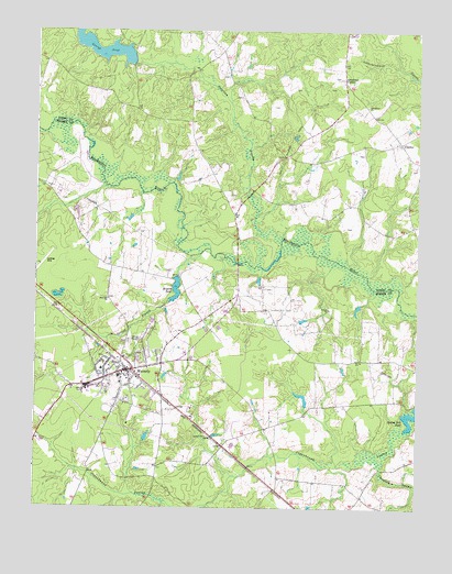
Waverly, VA USGS Topographic Map
Click on map above to begin viewing in our Map Viewer.

This topographic map contains these locations and features:
Feature Name Type Latitude Longitude GNIS ID View Map
Annie B Jackson Elementary SchoolSchoolN37.0360°W77.1034°1690172View Map
Avery DamDamN37.1163°W77.0933°1490914View Map
Avery MillpondSwampN37.1196°W77.0993°1490915View Map
Averys PondReservoirN37.1163°W77.0933°1462631View Map
Blunts BridgeBridgeN37.0640°W77.0589°1690182View Map
Bryant DamDamN37.0607°W77.0783°1490975View Map
Bryant PondReservoirN37.0573°W77.0790°1501965View Map
CarsleyPopulated PlaceN37.0957°W77.0058°1477180View Map
Carsley ChurchChurchN37.0960°W77.0066°1740126View Map
Chinquapin SwampStreamN37.0127°W77.0116°1464867View Map
Coppahawk SpringSpringN37.0101°W77.1108°1690195View Map
Faith Baptist Church SchoolSchoolN37.0391°W77.0729°2465146View Map
Gwaltney CornerPopulated PlaceN37.1118°W77.0239°1477384View Map
Hercules Incorporated Fire BrigadeBuildingN37.0892°W77.0011°2085891View Map
Jerusalem ChurchChurchN37.1054°W77.0166°1468702View Map
Johnsons Mill (historical)LocaleN37.0607°W77.0786°1690224View Map
Otterdam School (historical)SchoolN37.0849°W77.0514°1740148View Map
Otterdam SwampStreamN37.0704°W77.0441°1471972View Map
Spring BranchStreamN37.0665°W77.0711°1474974View Map
Spring Hill PondSwampN37.0245°W77.0014°1475007View Map
Spring Hill School (historical)SchoolN37.0393°W77.0180°1690254View Map
Town of WaverlyCivilN37.0340°W77.0956°2391473View Map
Virginia State Police Division 5 Area 36 OfficeBuildingN37.0389°W77.0801°2332145View Map
WaverlyPopulated PlaceN37.0360°W77.0952°1500286View Map
Waverly Airport (historical)AirportN37.0632°W77.1236°1690263View Map
Waverly CemeteryCemeteryN37.0435°W77.0952°1690264View Map
Waverly DistrictCivilN37.0415°W77.0964°1927556View Map
Waverly High School (historical)SchoolN37.0363°W77.1033°1690265View Map
Waverly Police DepartmentBuildingN37.0346°W77.0940°2085904View Map
Waverly Post OfficePost OfficeN37.0357°W77.0954°2767265View Map
Waverly Rescue SquadBuildingN37.0350°W77.0940°2331637View Map
Waverly Volunteer Fire DepartmentBuildingN37.0344°W77.0939°2085899View Map
White DamDamN37.0268°W77.0364°1490974View Map
Zion Hill ChurchChurchN37.0549°W77.1005°1474414View Map

Note: Coordinates in the location and feature list above are referenced to NAD83 datum.


Copyright (C) 2008-2025 Ryan Niemi / Sunset Dynamics ... All Rights Reserved