TopoQuest Logo
Do you find TopoQuest useful?
Help keep TopoQuest running and adding new maps/features by donating!
Bitcoin:  19c7KJd3qBynnjoSw5npx9KScwjBe4ifkT
Litecoin:  LXs6TkuXGGXo1vDsWCkWVdjQX94eUKd6ui
Home View Maps Find Maps Find Places Resources & Links


Littleton, Virginia Topographic Map

USGS Map Title: Littleton, VA
USGS Map MRC: 36077H2
DRG (GeoTIFF) Download: o36077h2.tif


Neighboring USGS Topographic Map Quads:


  Templeton, VA  
37077A3
 

  Disputanta South, VA  
37077A2
 

  Waverly, VA  
37077A1
 

  Sussex, VA  
36077H3
 

  Littleton, VA  
36077H2
 

  Manry, VA  
36077H1
 

  Yale, VA  
36077G3
 

  Sebrell, VA  
36077G2
 

  Vicksville, VA  
36077G1


Map MRC Location:

N37°
W78°
N37°
W77°
H8 H7 H6 H5 H4 H3 H2 H1
G8 G7 G6 G5 G4 G3 G2 G1
F8 F7 F6 F5 F4 F3 F2 F1
E8 E7 E6 E5 E4 E3 E2 E1
D8 D7 D6 D5 D4 D3 D2 D1
C8 C7 C6 C5 C4 C3 C2 C1
B8 B7 B6 B5 B4 B3 B2 B1
A8 A7 A6 A5 A4 A3 A2 A1
N36°
W78°
N36°
W77°

Littleton, VA USGS 1:24K Topographic Map Preview:
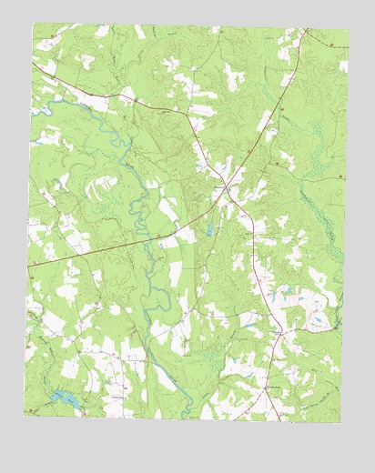
Littleton, VA USGS Topographic Map
Click on map above to begin viewing in our Map Viewer.

This topographic map contains these locations and features:
Feature Name Type Latitude Longitude GNIS ID View Map
Allens Bridge (historical)BridgeN36.8927°W77.1980°1690171View Map
Anderson BranchStreamN36.9040°W77.2455°1462457View Map
Austin BranchStreamN36.8782°W77.1841°1462618View Map
Barretts StoreLocaleN36.8854°W77.1547°1462813View Map
Burt (historical)Populated PlaceN36.9102°W77.1822°1690185View Map
Cape Charles Spring BranchStreamN36.8854°W77.1266°1464430View Map
Church (historical)Populated PlaceN36.8890°W77.2025°1690189View Map
Easter CemeteryCemeteryN36.9349°W77.1616°1690198View Map
Easter ChurchChurchN36.9346°W77.1611°1466122View Map
HomevillePopulated PlaceN36.9488°W77.1714°1495711View Map
Homeville School (historical)SchoolN36.9340°W77.1611°1690211View Map
Honey DamDamN36.8807°W77.2336°1490927View Map
Honey PondReservoirN36.8809°W77.2334°1468210View Map
Jennies BranchStreamN36.9954°W77.2000°1468682View Map
Lees BranchStreamN36.8796°W77.2377°1469275View Map
LittletonPopulated PlaceN36.9027°W77.1491°1477494View Map
Littleton School (historical)SchoolN36.8915°W77.1527°1690227View Map
LumbertonPopulated PlaceN36.8815°W77.2105°1477504View Map
Mussel SwampSwampN36.9966°W77.1578°1690231View Map
Nebletts Mill RunStreamN36.9627°W77.2097°1471357View Map
Newville DistrictCivilN36.9767°W77.1956°1927423View Map
Oak Grove ChurchChurchN36.8943°W77.1522°1471708View Map
Oakland CemeteryCemeteryN36.9401°W77.1655°1690240View Map
Patrick Henry Radio Range Station (historical)LocaleN36.9677°W77.1827°1690242View Map
Plank Road ChurchChurchN36.9721°W77.1977°1472461View Map
Plank Road School (historical)SchoolN36.9724°W77.1983°1690245View Map
Renney DamDamN36.9335°W77.1780°1490965View Map
Renney PondReservoirN36.9356°W77.1778°1490966View Map
Spring BranchStreamN36.9846°W77.2158°1474979View Map
Underhill BranchStreamN36.9968°W77.1952°1476018View Map

Note: Coordinates in the location and feature list above are referenced to NAD83 datum.


Copyright (C) 2008-2025 Ryan Niemi / Sunset Dynamics ... All Rights Reserved