TopoQuest Logo
Do you find TopoQuest useful?
Help keep TopoQuest running and adding new maps/features by donating!
Bitcoin:  19c7KJd3qBynnjoSw5npx9KScwjBe4ifkT
Litecoin:  LXs6TkuXGGXo1vDsWCkWVdjQX94eUKd6ui
Home View Maps Find Maps Find Places Resources & Links


Wayland, Texas Topographic Map

USGS Map Title: Wayland, TX
USGS Map MRC: 32098E7
DRG (GeoTIFF) Download: o32098e7.tif


Neighboring USGS Topographic Map Quads:


  Buck Mountain, TX  
32098F8
 

  Necessity, TX  
32098F7
 

  Caddo, TX  
32098F6
 

  Harpersville, TX  
32098E8
 

  Wayland, TX  
32098E7
 

  La Casa, TX  
32098E6
 

  Cisco North, TX  
32098D8
 

  Eastland, TX  
32098D7
 

  Ranger, TX  
32098D6


Map MRC Location:

N33°
W99°
N33°
W98°
H8 H7 H6 H5 H4 H3 H2 H1
G8 G7 G6 G5 G4 G3 G2 G1
F8 F7 F6 F5 F4 F3 F2 F1
E8 E7 E6 E5 E4 E3 E2 E1
D8 D7 D6 D5 D4 D3 D2 D1
C8 C7 C6 C5 C4 C3 C2 C1
B8 B7 B6 B5 B4 B3 B2 B1
A8 A7 A6 A5 A4 A3 A2 A1
N32°
W99°
N32°
W98°

Wayland, TX USGS 1:24K Topographic Map Preview:
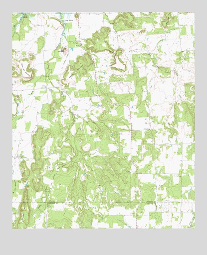
Wayland, TX USGS Topographic Map
Click on map above to begin viewing in our Map Viewer.

This topographic map contains these locations and features:
Feature Name Type Latitude Longitude GNIS ID View Map
Acker CemeteryCemeteryN32.5612°W98.7820°1329186View Map
Bald MountainSummitN32.6026°W98.8387°1329974View Map
Big BranchStreamN32.6246°W98.8676°1372526View Map
Brown Pen MountainSummitN32.5879°W98.8642°1331356View Map
Community BuildingBuildingN32.6082°W98.8284°1889934View Map
Gibon Lake DamDamN32.5351°W98.7720°1861126View Map
Gibson LakeReservoirN32.5351°W98.7720°1861127View Map
GunsightPopulated PlaceN32.5415°W98.8712°1378397View Map
Gunsight MountainSummitN32.5110°W98.8651°1337136View Map
Maxwell MountainSummitN32.5907°W98.8265°1341102View Map
Middle Fork Gunsolus CreekStreamN32.5923°W98.8492°1341488View Map
Steal Easy MountainSummitN32.6232°W98.7678°1347840View Map
WaylandPopulated PlaceN32.6096°W98.8281°1379246View Map
West Fork Gunsolus CreekStreamN32.5923°W98.8492°1376697View Map

Note: Coordinates in the location and feature list above are referenced to NAD83 datum.


Copyright (C) 2008-2025 Ryan Niemi / Sunset Dynamics ... All Rights Reserved