TopoQuest Logo
Do you find TopoQuest useful?
Help keep TopoQuest running and adding new maps/features by donating!
Bitcoin:  19c7KJd3qBynnjoSw5npx9KScwjBe4ifkT
Litecoin:  LXs6TkuXGGXo1vDsWCkWVdjQX94eUKd6ui
Home View Maps Find Maps Find Places Resources & Links


Weldon, California Topographic Map

USGS Map Title: Weldon, CA
USGS Map MRC: 35118F3
DRG (GeoTIFF) Download: o35118f3.tif


Neighboring USGS Topographic Map Quads:


  Kernville, CA  
35118G4
 

  Cannell Peak, CA  
35118G3
 

  White Dome, CA  
35118G2
 

  Lake Isabella North, CA  
35118F4
 

  Weldon, CA  
35118F3
 

  Onyx, CA  
35118F2
 

  Lake Isabella South, CA  
35118E4
 

  Woolstalf Creek, CA  
35118E3
 

  Cane Canyon, CA  
35118E2


Map MRC Location:

N36°
W119°
N36°
W118°
H8 H7 H6 H5 H4 H3 H2 H1
G8 G7 G6 G5 G4 G3 G2 G1
F8 F7 F6 F5 F4 F3 F2 F1
E8 E7 E6 E5 E4 E3 E2 E1
D8 D7 D6 D5 D4 D3 D2 D1
C8 C7 C6 C5 C4 C3 C2 C1
B8 B7 B6 B5 B4 B3 B2 B1
A8 A7 A6 A5 A4 A3 A2 A1
N35°
W119°
N35°
W118°

Weldon, CA USGS 1:24K Topographic Map Preview:
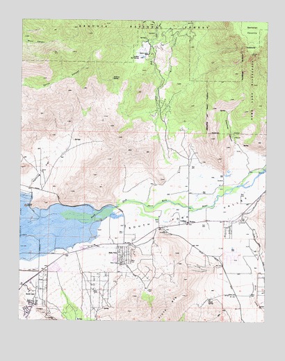
Weldon, CA USGS Topographic Map
Click on map above to begin viewing in our Map Viewer.

This topographic map contains these locations and features:
Feature Name Type Latitude Longitude GNIS ID View Map
Andress SpringSpringN35.7259°W118.3297°238615View Map
Ashley Hot SpringSpringN35.7351°W118.3161°238804View Map
Bella VistaPopulated PlaceN35.6522°W118.3226°1660324View Map
Bradys Pack Station (historical)LocaleN35.7472°W118.3006°1670214View Map
Brown MillLocaleN35.6666°W118.2990°1835935View Map
Burnt CanyonValleyN35.7183°W118.3073°239868View Map
Camp FifteenLocaleN35.6550°W118.3476°275123View Map
Fay CreekStreamN35.6900°W118.2990°242187View Map
Freedom Hill Ranch (historical)LocaleN35.6297°W118.3323°275121View Map
Gibonney CanyonValleyN35.6936°W118.2681°242697View Map
Goat Ranch CanyonValleyN35.6361°W118.3659°242765View Map
Hanning FlatFlatN35.6869°W118.3654°243175View Map
Kelso CreekStreamN35.6597°W118.2709°244233View Map
Kern County Fire Department Station 71 - SouthlakeBuildingN35.6468°W118.3607°2665341View Map
Kern River PreserveParkN35.6694°W118.3162°1835945View Map
Long CanyonValleyN35.6305°W118.3406°255630View Map
Moon RanchLocaleN35.6380°W118.3112°275122View Map
Nicoll SpringSpringN35.6334°W118.2797°246534View Map
Quarter Circle 5 RanchLocaleN35.7363°W118.3120°247871View Map
Rabbit IslandIslandN35.6725°W118.3729°247904View Map
South Fork Elementary SchoolSchoolN35.6661°W118.2912°249719View Map
South Fork ValleyValleyN35.6663°W118.3345°249726View Map
South Fork Wildlife AreaParkN35.6680°W118.3301°1835954View Map
South LakePopulated PlaceN35.6369°W118.3670°1661474View Map
Welden Post OfficePost OfficeN35.6561°W118.3270°2769525View Map
WeldonPopulated PlaceN35.6658°W118.2904°255860View Map
Weldon Census Designated PlaceCensusN35.6431°W118.3102°2409540View Map

Note: Coordinates in the location and feature list above are referenced to NAD83 datum.


Copyright (C) 2008-2024 Ryan Niemi / Sunset Dynamics ... All Rights Reserved