TopoQuest Logo
Do you find TopoQuest useful?
Help keep TopoQuest running and adding new maps/features by donating!
Bitcoin:  19c7KJd3qBynnjoSw5npx9KScwjBe4ifkT
Litecoin:  LXs6TkuXGGXo1vDsWCkWVdjQX94eUKd6ui
Home View Maps Find Maps Find Places Resources & Links


Lake Isabella South, California Topographic Map

USGS Map Title: Lake Isabella South, CA
USGS Map MRC: 35118E4
DRG (GeoTIFF) Download: o35118e4.tif


Neighboring USGS Topographic Map Quads:


  Alta Sierra, CA  
35118F5
 

  Lake Isabella North, CA  
35118F4
 

  Weldon, CA  
35118F3
 

  Miracle Hot Springs, CA  
35118E5
 

  Lake Isabella South, CA  
35118E4
 

  Woolstalf Creek, CA  
35118E3
 

  Breckenridge Mountain, CA  
35118D5
 

  Piute Peak, CA  
35118D4
 

  Claraville, CA  
35118D3


Map MRC Location:

N36°
W119°
N36°
W118°
H8 H7 H6 H5 H4 H3 H2 H1
G8 G7 G6 G5 G4 G3 G2 G1
F8 F7 F6 F5 F4 F3 F2 F1
E8 E7 E6 E5 E4 E3 E2 E1
D8 D7 D6 D5 D4 D3 D2 D1
C8 C7 C6 C5 C4 C3 C2 C1
B8 B7 B6 B5 B4 B3 B2 B1
A8 A7 A6 A5 A4 A3 A2 A1
N35°
W119°
N35°
W118°

Lake Isabella South, CA USGS 1:24K Topographic Map Preview:
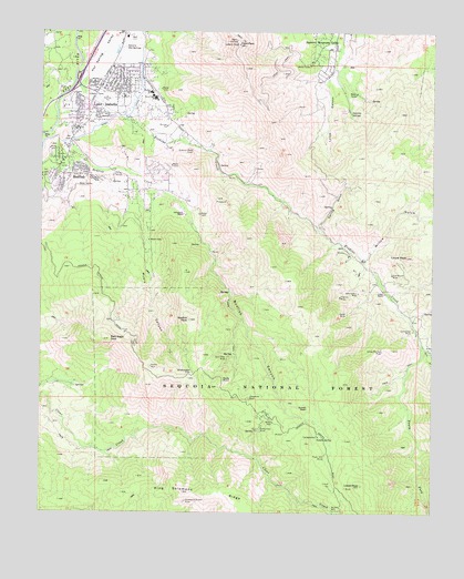
Lake Isabella South, CA USGS Topographic Map
Click on map above to begin viewing in our Map Viewer.

This topographic map contains these locations and features:
Feature Name Type Latitude Longitude GNIS ID View Map
Bald Eagle PeakSummitN35.5450°W118.4790°269639View Map
BodfishPopulated PlaceN35.5880°W118.4920°1660353View Map
Bodfish CanyonValleyN35.5852°W118.4640°269947View Map
Bodfish Census Designated PlaceCensusN35.5765°W118.4764°2407873View Map
Bodfish CreekStreamN35.6002°W118.4968°239530View Map
Bodfish PeakSummitN35.5502°W118.4540°269948View Map
Bodfish Post OfficePost OfficeN35.5906°W118.4968°2769324View Map
Borel CanalCanalN35.6030°W118.4754°269971View Map
Brady RanchLocaleN35.6183°W118.4034°275133View Map
Burton MillPopulated PlaceN35.5005°W118.4070°1660397View Map
Cook PeakSummitN35.6216°W118.4395°270587View Map
Cook Peak LookoutLocaleN35.6216°W118.4381°275132View Map
Devils Hole MineMineN35.5438°W118.4540°1835851View Map
Devils Hole North ProspectMineN35.5472°W118.4565°1835852View Map
Devils Hole South ProspectMineN35.5383°W118.4548°1835853View Map
Double S RanchLocaleN35.5866°W118.4801°275131View Map
Drunkards Dream MineMineN35.5030°W118.4548°270916View Map
East Fork Erskine CreekStreamN35.5430°W118.3779°270991View Map
Erskine CreekStreamN35.6113°W118.4906°271070View Map
Faust MillLocaleN35.5152°W118.4101°271108View Map
Faust MineMineN35.5183°W118.4106°1670222View Map
Flood RanchLocaleN35.5655°W118.3979°275129View Map
GarfieldLocaleN35.6030°W118.4873°275134View Map
Gautche SpringsSpringN35.6034°W118.4023°271281View Map
Glen Olive MineMineN35.5402°W118.4418°242737View Map
Harrington RanchLocaleN35.5775°W118.4562°243244View Map
Heavens Delight MineMineN35.5583°W118.4598°1835868View Map
Hot Spring ValleyValleyN35.6002°W118.4968°271669View Map
Iconoclast MineMineN35.5475°W118.3820°271703View Map
James Morden MineMineN35.5422°W118.3920°271764View Map
Jeanette Grant MineMineN35.5319°W118.3970°275127View Map
Josephine MineMineN35.5294°W118.4345°244141View Map
Juniper Hills Country ClubLocaleN35.5861°W118.4759°1835882View Map
Kern County Fire Department Station 72 - Lake IsabellaBuildingN35.6038°W118.4857°2665344View Map
Kern Valley High SchoolSchoolN35.6094°W118.4671°271881View Map
KernvaleLocaleN35.6125°W118.4806°275136View Map
KKRV-FM (Kernville)TowerN35.6225°W118.4387°1662910View Map
KVLI-FM (Lake Isabella)TowerN35.6225°W118.4387°1662915View Map
Lake IsabellaPopulated PlaceN35.6180°W118.4731°1652739View Map
Lake Isabella DivisionCivilN35.5931°W118.4771°1935157View Map
Laura PeakSummitN35.5663°W118.3842°271993View Map
Laurel MineMineN35.5516°W118.4031°271996View Map
Liebel PeakSummitN35.5072°W118.3984°272026View Map
Liebel RanchLocaleN35.5569°W118.3915°272027View Map
Lynch CanyonValleyN35.6127°W118.4101°272288View Map
Middle Fork Erskine CreekStreamN35.5430°W118.3779°272440View Map
Myers CanyonValleyN35.5877°W118.4734°272614View Map
Myers RanchLocaleN35.5758°W118.4693°275130View Map
Opportunity SubSection Number 4 ProspectMineN35.5400°W118.4606°1835894View Map
Rocky Hill ProspectMineN35.5572°W118.4587°1836031View Map
Rocky PointCapeN35.5355°W118.4406°1654907View Map
Russell RanchLocaleN35.5466°W118.3806°275128View Map
Saddle SpringSpringN35.5193°W118.4123°273390View Map
Scovern Hot SpringsSpringN35.6209°W118.4742°273616View Map
Scovern Hot Springs (historical)Populated PlaceN35.6213°W118.4743°1670232View Map
Seventyfour MineMineN35.5572°W118.3998°273643View Map
South Fork Erskine CreekStreamN35.5444°W118.3798°273822View Map
Spring GulchValleyN35.5752°W118.4140°273869View Map
Squirrel Mountain ValleyPopulated PlaceN35.6233°W118.4098°1661499View Map
Squirrel Mountain Valley Census Designated PlaceCensusN35.6175°W118.4047°2408800View Map
Studebaker FlatFlatN35.5366°W118.4523°273931View Map
Summit Continuation High SchoolSchoolN35.6077°W118.4648°1835916View Map
Sunset PointSummitN35.5275°W118.4156°1661534View Map
Tom Moore MineMineN35.5619°W118.3890°274155View Map
Tripoli ProspectMineN35.5502°W118.4765°1835919View Map
Uffert ParkParkN35.6080°W118.4843°274262View Map
Valley View MineMineN35.5213°W118.4315°274309View Map
Vaughn School (historical)SchoolN35.5908°W118.4970°1670236View Map
Virginia MineMineN35.5561°W118.4056°274348View Map
Wallace Elementary SchoolSchoolN35.6074°W118.4638°274372View Map
White Rock MineMineN35.6147°W118.4990°275135View Map
Willow GulchValleyN35.5661°W118.3992°274521View Map

Note: Coordinates in the location and feature list above are referenced to NAD83 datum.


Copyright (C) 2008-2024 Ryan Niemi / Sunset Dynamics ... All Rights Reserved