TopoQuest Logo
Do you find TopoQuest useful?
Help keep TopoQuest running and adding new maps/features by donating!
Bitcoin:  19c7KJd3qBynnjoSw5npx9KScwjBe4ifkT
Litecoin:  LXs6TkuXGGXo1vDsWCkWVdjQX94eUKd6ui
Home View Maps Find Maps Find Places Resources & Links


West Beckwith Mountain, Colorado Topographic Map

USGS Map Title: West Beckwith Mountain, CO
USGS Map MRC: 38107G3
DRG (GeoTIFF) Download: o38107g3.tif


Neighboring USGS Topographic Map Quads:


  Somerset, CO  
38107H4
 

  Paonia Reservoir, CO  
38107H3
 

  Marcellina Mountain, CO  
38107H2
 

  Minnesota Pass, CO  
38107G4
 

  West Beckwith Mountain, CO  
38107G3
 

  Anthracite Range, CO  
38107G2
 

  Mount Guero, CO  
38107F4
 

  Big Soap Park, CO  
38107F3
 

  West Elk Peak, CO  
38107F2


Map MRC Location:

N39°
W108°
N39°
W107°
H8 H7 H6 H5 H4 H3 H2 H1
G8 G7 G6 G5 G4 G3 G2 G1
F8 F7 F6 F5 F4 F3 F2 F1
E8 E7 E6 E5 E4 E3 E2 E1
D8 D7 D6 D5 D4 D3 D2 D1
C8 C7 C6 C5 C4 C3 C2 C1
B8 B7 B6 B5 B4 B3 B2 B1
A8 A7 A6 A5 A4 A3 A2 A1
N38°
W108°
N38°
W107°

West Beckwith Mountain, CO USGS 1:24K Topographic Map Preview:
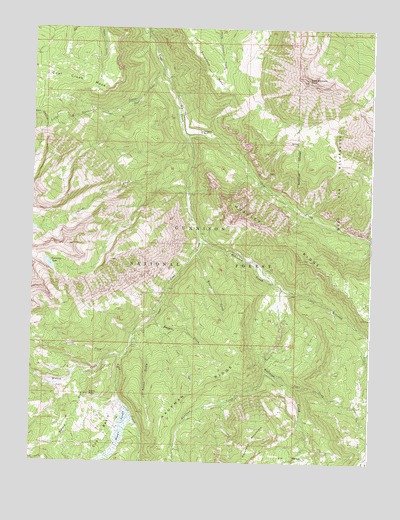
West Beckwith Mountain, CO USGS Topographic Map
Click on map above to begin viewing in our Map Viewer.

This topographic map contains these locations and features:
Feature Name Type Latitude Longitude GNIS ID View Map
Beaver JungleSwampN38.7573°W107.3431°203242View Map
Cascade CreekStreamN38.8372°W107.3167°186629View Map
Cliff CreekStreamN38.8436°W107.3178°186630View Map
Coal BasinBasinN38.7580°W107.3478°203243View Map
Coal Creek MesaSummitN38.8603°W107.3667°203219View Map
Cutler CreekStreamN38.7805°W107.3451°186610View Map
Davenport RanchLocaleN38.8453°W107.3139°186628View Map
Gunnison LakeLakeN38.8069°W107.3688°186645View Map
Hammond TrailTrailN38.8519°W107.3412°186646View Map
Kaufman CreekStreamN38.7764°W107.2884°186637View Map
Little Gunnison CreekStreamN38.8633°W107.3281°186617View Map
Little Robinson Cow CampLocaleN38.7661°W107.2545°186642View Map
Little Robinson CreekStreamN38.8005°W107.2834°186643View Map
Moseley RidgeRidgeN38.8228°W107.3012°203241View Map
Navajo CabinLocaleN38.7833°W107.3384°186634View Map
Navajo GulchValleyN38.7862°W107.3378°186633View Map
Peter CreekStreamN38.7755°W107.2859°186640View Map
Ranger CreekStreamN38.7925°W107.3301°186632View Map
Robinson CreekStreamN38.8139°W107.3159°186638View Map
Sams PeakSummitN38.7694°W107.3534°186636View Map
Snowshoe MesaSummitN38.8567°W107.3076°203217View Map
Spruce DrawValleyN38.7763°W107.3524°186635View Map
Wapiti CreekStreamN38.8097°W107.3151°186631View Map
West Beckwith MountainSummitN38.8597°W107.2742°186627View Map
Willow CreekStreamN38.7805°W107.3423°186611View Map

Note: Coordinates in the location and feature list above are referenced to NAD83 datum.


Copyright (C) 2008-2025 Ryan Niemi / Sunset Dynamics ... All Rights Reserved