TopoQuest Logo
Do you find TopoQuest useful?
Help keep TopoQuest running and adding new maps/features by donating!
Bitcoin:  19c7KJd3qBynnjoSw5npx9KScwjBe4ifkT
Litecoin:  LXs6TkuXGGXo1vDsWCkWVdjQX94eUKd6ui
Home View Maps Find Maps Find Places Resources & Links


West Newfield, Maine Topographic Map

USGS Map Title: West Newfield, ME
USGS Map MRC: 43070F8
DRG (GeoTIFF) Download: o43070f8.tif


Neighboring USGS Topographic Map Quads:


  Freedom, NH  
43071G1
 

  Kezar Falls, ME  
43070G8
 

  Cornish, ME  
43070G7
 

  Ossipee, NH  
43071F1
 

  West Newfield, ME  
43070F8
 

  Limerick, ME  
43070F7
 

  Sanbornville, NH  
43071E1
 

  Great East Lake, ME  
43070E8
 

  Mousam Lake, ME  
43070E7


Map MRC Location:

N44°
W71°
N44°
W70°
H8 H7 H6 H5 H4 H3 H2 H1
G8 G7 G6 G5 G4 G3 G2 G1
F8 F7 F6 F5 F4 F3 F2 F1
E8 E7 E6 E5 E4 E3 E2 E1
D8 D7 D6 D5 D4 D3 D2 D1
C8 C7 C6 C5 C4 C3 C2 C1
B8 B7 B6 B5 B4 B3 B2 B1
A8 A7 A6 A5 A4 A3 A2 A1
N43°
W71°
N43°
W70°

West Newfield, ME USGS 1:24K Topographic Map Preview:
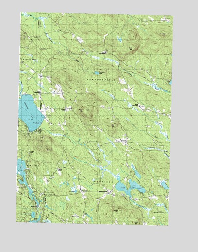
West Newfield, ME USGS Topographic Map
Click on map above to begin viewing in our Map Viewer.

This topographic map contains these locations and features:
Feature Name Type Latitude Longitude GNIS ID View Map
Bally-Hoo CampgroundLocaleN43.6812°W70.9953°1915873View Map
Belleau LakeReservoirN43.6542°W70.9949°866614View Map
Belleau Lake DamDamN43.6434°W70.9862°1775156View Map
Carleton Ham CemeteryCemeteryN43.6414°W70.9445°2741955View Map
Cedar MountainSummitN43.7304°W70.9061°563728View Map
Champion PondLakeN43.7148°W70.9362°563810View Map
Colcord HillSummitN43.7351°W70.9981°866261View Map
Congregational Church CemeteryCemeteryN43.6451°W70.9216°2737149View Map
Dearborn MountainSummitN43.7390°W70.8781°564924View Map
Drew PondLakeN43.6440°W70.9515°565289View Map
East Wakefield Post OfficePost OfficeN43.6418°W70.9790°1915946View Map
Effingham Post OfficePost OfficeN43.7160°W70.9900°2760150View Map
Emerson BrookStreamN43.7465°W70.9809°565893View Map
Hobbs BrookStreamN43.7484°W70.9978°867525View Map
Libby CemeteryCemeteryN43.6734°W70.8865°2736509View Map
Little Ossipee River ReservoirReservoirN43.6351°W70.9828°1775159View Map
MaplewoodPopulated PlaceN43.6742°W70.9109°570747View Map
Mee CornersPopulated PlaceN43.6440°W70.9467°571119View Map
Mitchell MountainSummitN43.6330°W70.9158°571473View Map
Moore Thompson CemeteryCemeteryN43.6677°W70.9111°2736550View Map
Newfield Fire Department Rescue SquadBuildingN43.6396°W70.8989°2552737View Map
North Newfield CemeteryCemeteryN43.6714°W70.9115°2737156View Map
Page MountainSummitN43.6839°W70.9202°572921View Map
ParsonsfieldPopulated PlaceN43.7270°W70.9287°573021View Map
Providence Lake BeachBeachN43.6812°W70.9842°1916091View Map
Province LakeLocaleN43.6656°W70.9909°869385View Map
Province LakeLakeN43.6907°W70.9947°573846View Map
Province Lake Country ClubLocaleN43.6890°W70.9745°1911108View Map
Province MountainSummitN43.6690°W70.9768°573847View Map
Reed CemeteryCemeteryN43.6309°W70.9431°1911112View Map
Roberts CornerPopulated PlaceN43.6934°W70.9612°579660View Map
Rock Haven LakeReservoirN43.6475°W70.9124°574340View Map
Rock Haven Lake DamDamN43.6409°W70.9070°1773591View Map
Sand PondLakeN43.6298°W70.9855°869771View Map
South EffinghamPopulated PlaceN43.7012°W70.9834°870033View Map
South EffinghamPopulated PlaceN43.7020°W70.9817°575838View Map
South ParsonsfieldPopulated PlaceN43.6959°W70.8998°575878View Map
South Parsonsfield Free Baptist ChurchChurchN43.6954°W70.9009°1911190View Map
Stevens CemeteryCemeteryN43.6540°W70.9693°2737279View Map
Stevens CornerPopulated PlaceN43.6573°W70.9670°579741View Map
Symmes PondReservoirN43.6488°W70.8782°576629View Map
Taylor CemeteryCemeteryN43.7115°W70.9751°2737290View Map
Town House CemeteryCemeteryN43.7290°W70.9295°2737308View Map
Town of NewfieldCivilN43.6404°W70.9049°582618View Map
Town of ParsonsfieldCivilN43.7356°W70.9115°582662View Map
Tuck Family CemeteryCemeteryN43.6842°W70.9727°2737316View Map
Wakefield Fire Rescue Station 2BuildingN43.6347°W70.9810°2605018View Map
West NewfieldPopulated PlaceN43.6440°W70.9237°578180View Map
Wiggin MountainSummitN43.6930°W70.9462°578450View Map
WoodmanPopulated PlaceN43.6348°W70.9828°870984View Map
Woodman DamDamN43.6351°W70.9828°1775158View Map

Note: Coordinates in the location and feature list above are referenced to NAD83 datum.


Copyright (C) 2008-2024 Ryan Niemi / Sunset Dynamics ... All Rights Reserved