TopoQuest Logo
Do you find TopoQuest useful?
Help keep TopoQuest running and adding new maps/features by donating!
Bitcoin:  19c7KJd3qBynnjoSw5npx9KScwjBe4ifkT
Litecoin:  LXs6TkuXGGXo1vDsWCkWVdjQX94eUKd6ui
Home View Maps Find Maps Find Places Resources & Links


West of Greens Bayou, Texas Topographic Map

USGS Map Title: West of Greens Bayou, TX
USGS Map MRC: 29093H7
DRG (GeoTIFF) Download: o29093h7.tif


Neighboring USGS Topographic Map Quads:


  Terry, TX  
30093A8
 

  Orangefield, TX  
30093A7
 

  Orange, TX  
30093A6
 

  Port Arthur North, TX  
29093H8
 

  West of Greens Bayou, TX  
29093H7


  Port Arthur South, TX  
29093G8
 

  West of Johnson Bayou, LA  
29093G7


Map MRC Location:

N30°
W94°
N30°
W93°
H8 H7 H6 H5 H4 H3 H2 H1
G8 G7 G6 G5 G4 G3 G2 G1
F8 F7 F6 F5 F4 F3 F2 F1
E8 E7 E6 E5 E4 E3 E2 E1
D8 D7 D6 D5 D4 D3 D2 D1
C8 C7 C6 C5 C4 C3 C2 C1
B8 B7 B6 B5 B4 B3 B2 B1
A8 A7 A6 A5 A4 A3 A2 A1
N29°
W94°
N29°
W93°

West of Greens Bayou, TX USGS 1:24K Topographic Map Preview:
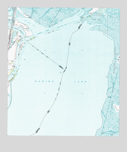
West of Greens Bayou, TX USGS Topographic Map
Click on map above to begin viewing in our Map Viewer.

This topographic map contains these locations and features:
Feature Name Type Latitude Longitude GNIS ID View Map
Bland CanalCanalN29.9869°W93.8677°1352401View Map
Bridge BayouStreamN29.8888°W93.7629°533390View Map
Coffee Ground CoveBayN29.9699°W93.7666°534024View Map
Coon BayouStreamN29.9955°W93.7904°1388226View Map
Dooms IslandIslandN29.9663°W93.8493°1356163View Map
East PassBayN29.9829°W93.7814°534738View Map
Goat IslandIslandN29.9863°W93.7946°1384085View Map
Grays CanalBayN29.9501°W93.7505°549605View Map
Grays DitchBayN29.8983°W93.7637°546379View Map
Hickory CoveBayN29.9947°W93.7935°1359113View Map
Humble IslandIslandN29.9772°W93.8532°1359817View Map
Little West PassChannelN29.9930°W93.7893°1361499View Map
Marceaux IslandIslandN29.9019°W93.7516°536892View Map
Middle PassChannelN29.9880°W93.7888°537063View Map
Middle PassChannelN29.9872°W93.7904°1362736View Map
Neches RiverStreamN29.9688°W93.8557°1375103View Map
Old River BayouStreamN29.9877°W93.8463°1375279View Map
Old River CoveBayN29.9844°W93.8493°1364474View Map
Port Arthur-Orange BridgeBridgeN29.9827°W93.8716°2030673View Map
Rainbow MarinaLocaleN29.9772°W93.8729°2030484View Map
Sabine LakeLakeN29.8861°W93.8419°555871View Map
Sabine RiverStreamN29.9855°W93.7904°555872View Map
Shell IslandIslandN29.9891°W93.7752°544869View Map
Stewts IslandIslandN29.9699°W93.8471°1369195View Map
Sydnes IslandIslandN29.9769°W93.8254°1369512View Map
Three BayouBayN29.9137°W93.7609°539903View Map
West PassChannelN29.9894°W93.7916°1371185View Map
Whisky BayouBayN29.9214°W93.7616°540353View Map

Note: Coordinates in the location and feature list above are referenced to NAD83 datum.


Copyright (C) 2008-2025 Ryan Niemi / Sunset Dynamics ... All Rights Reserved