TopoQuest Logo
Do you find TopoQuest useful?
Help keep TopoQuest running and adding new maps/features by donating!
Bitcoin:  19c7KJd3qBynnjoSw5npx9KScwjBe4ifkT
Litecoin:  LXs6TkuXGGXo1vDsWCkWVdjQX94eUKd6ui
Home View Maps Find Maps Find Places Resources & Links


Westcliffe, Colorado Topographic Map

USGS Map Title: Westcliffe, CO
USGS Map MRC: 38105B4
DRG (GeoTIFF) Download: o38105b4.tif


Neighboring USGS Topographic Map Quads:


  Hillside, CO  
38105C5
 

  Iron Mountain, CO  
38105C4
 

  Curley Peak, CO  
38105C3
 

  Beckwith Mountain, CO  
38105B5
 

  Westcliffe, CO  
38105B4
 

  Mount Tyndall, CO  
38105B3
 

  Horn Peak, CO  
38105A5
 

  Aldrich Gulch, CO  
38105A4
 

  Rosita, CO  
38105A3


Map MRC Location:

N39°
W106°
N39°
W105°
H8 H7 H6 H5 H4 H3 H2 H1
G8 G7 G6 G5 G4 G3 G2 G1
F8 F7 F6 F5 F4 F3 F2 F1
E8 E7 E6 E5 E4 E3 E2 E1
D8 D7 D6 D5 D4 D3 D2 D1
C8 C7 C6 C5 C4 C3 C2 C1
B8 B7 B6 B5 B4 B3 B2 B1
A8 A7 A6 A5 A4 A3 A2 A1
N38°
W106°
N38°
W105°

Westcliffe, CO USGS 1:24K Topographic Map Preview:
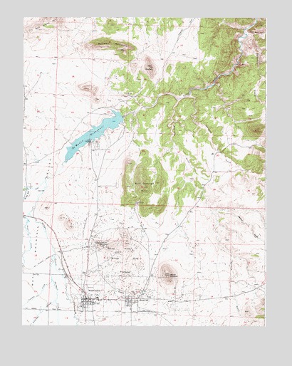
Westcliffe, CO USGS Topographic Map
Click on map above to begin viewing in our Map Viewer.

This topographic map contains these locations and features:
Feature Name Type Latitude Longitude GNIS ID View Map
Alvarado CreekStreamN38.1350°W105.4828°192150View Map
Ben West HillSummitN38.1575°W105.4600°192153View Map
Bull Domingo HillsSummitN38.1814°W105.4406°192147View Map
Bull Domingo MineMineN38.1775°W105.4400°1725057View Map
C H Connor MineMineN38.1378°W105.4456°1725058View Map
Carolina GulchValleyN38.1717°W105.4026°192148View Map
Chloride GulchValleyN38.1381°W105.4745°192159View Map
Custer County Emergency Medical ServicesBuildingN38.1338°W105.4624°2695588View Map
Custer County Medical CenterHospitalN38.1329°W105.4622°2695673View Map
Custer County Sheriff's OfficeBuildingN38.1344°W105.4624°2696637View Map
Dan Riggs Memorial HeliportAirportN38.1475°W105.4672°204622View Map
De Weese DamDamN38.2100°W105.4522°201360View Map
Dead Mule GulchValleyN38.2441°W105.3852°192161View Map
Deceiver MineMineN38.1650°W105.4572°1725059View Map
Defender MineMineN38.1544°W105.4522°192156View Map
Deweese-Dye ReservoirReservoirN38.2027°W105.4634°201361View Map
Dora MountainSummitN38.2297°W105.4350°192144View Map
Fourmile GulchValleyN38.2168°W105.4201°192163View Map
Green Mountain MineMineN38.1922°W105.4003°1725060View Map
Herman Passiflora MineMineN38.1589°W105.4628°192152View Map
Johnson GulchValleyN38.2184°W105.4146°192162View Map
Keystone MineMineN38.1650°W105.4344°1725061View Map
Lady Franklin MineMineN38.1603°W105.4442°1725062View Map
Lake DeWeese LodgeLocaleN38.1989°W105.4656°192146View Map
Lakeview MineMineN38.2281°W105.4347°1725063View Map
Luton CreekStreamN38.1667°W105.4983°192124View Map
Mitchell MountainSummitN38.2369°W105.4483°192143View Map
New Hope MineMineN38.1650°W105.4572°1725064View Map
Nutter ProspectMineN38.1872°W105.4492°1725056View Map
Oak Grove MountainSummitN38.2464°W105.4903°203573View Map
Quist Voss Land MineMineN38.2281°W105.4575°1725065View Map
Round MountainSummitN38.1458°W105.4333°192158View Map
Sevenmile GulchValleyN38.2431°W105.3823°192160View Map
Silver CliffPopulated PlaceN38.1353°W105.4464°192157View Map
Silver Cliff PlateauSummitN38.1519°W105.4411°192155View Map
Spring CreekStreamN38.1533°W105.4833°192149View Map
Spring RunStreamN38.1808°W105.4978°192112View Map
Stroelhke MineMineN38.1558°W105.4800°1725066View Map
Swift CreekStreamN38.1836°W105.4886°192110View Map
Taylor CreekStreamN38.1703°W105.4964°192117View Map
Town of WestcliffeCivilN38.1339°W105.4654°2413471View Map
Venable CreekStreamN38.1436°W105.4850°192113View Map
Wahl MineMineN38.1650°W105.4572°1725067View Map
WestcliffePopulated PlaceN38.1347°W105.4658°192151View Map
Westcliffe Post OfficePost OfficeN38.1352°W105.4595°2750995View Map
Wet Mountain Fire Protection District Station 1BuildingN38.1375°W105.4664°2667253View Map
Wet Mountain Fire Protection District Station 3 Lake DeweeseBuildingN38.1970°W105.4652°2695587View Map
White HillsSummitN38.1583°W105.4472°192154View Map

Note: Coordinates in the location and feature list above are referenced to NAD83 datum.


Copyright (C) 2008-2024 Ryan Niemi / Sunset Dynamics ... All Rights Reserved