TopoQuest Logo
Do you find TopoQuest useful?
Help keep TopoQuest running and adding new maps/features by donating!
Bitcoin:  19c7KJd3qBynnjoSw5npx9KScwjBe4ifkT
Litecoin:  LXs6TkuXGGXo1vDsWCkWVdjQX94eUKd6ui
Home View Maps Find Maps Find Places Resources & Links


Curley Peak, Colorado Topographic Map

USGS Map Title: Curley Peak, CO
USGS Map MRC: 38105C3
DRG (GeoTIFF) Download: o38105c3.tif


Neighboring USGS Topographic Map Quads:


  McIntyre Hills, CO  
38105D4
 

  Royal Gorge, CO  
38105D3
 

  Canon City, CO  
38105D2
 

  Iron Mountain, CO  
38105C4
 

  Curley Peak, CO  
38105C3
 

  Rockvale, CO  
38105C2
 

  Westcliffe, CO  
38105B4
 

  Mount Tyndall, CO  
38105B3
 

  Hardscrabble Mountain, CO  
38105B2


Map MRC Location:

N39°
W106°
N39°
W105°
H8 H7 H6 H5 H4 H3 H2 H1
G8 G7 G6 G5 G4 G3 G2 G1
F8 F7 F6 F5 F4 F3 F2 F1
E8 E7 E6 E5 E4 E3 E2 E1
D8 D7 D6 D5 D4 D3 D2 D1
C8 C7 C6 C5 C4 C3 C2 C1
B8 B7 B6 B5 B4 B3 B2 B1
A8 A7 A6 A5 A4 A3 A2 A1
N38°
W106°
N38°
W105°

Curley Peak, CO USGS 1:24K Topographic Map Preview:
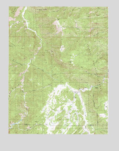
Curley Peak, CO USGS Topographic Map
Click on map above to begin viewing in our Map Viewer.

This topographic map contains these locations and features:
Feature Name Type Latitude Longitude GNIS ID View Map
A Griffin Ranch MineMineN38.2933°W105.2922°1724954View Map
Bear GulchValleyN38.3234°W105.3455°191824View Map
Big Chief One MineMineN38.2503°W105.2589°1724953View Map
Big Mac Group One-three MinesMineN38.2914°W105.3208°1724957View Map
Chute GulchValleyN38.3355°W105.3338°191818View Map
Chute ParkFlatN38.3333°W105.3089°191914View Map
Curley PeakSummitN38.3208°W105.2989°191849View Map
Deer Ridge ClaimMineN38.2617°W105.3297°1724956View Map
Democrat CreekStreamN38.2606°W105.3633°196545View Map
East Bear GulchValleyN38.3061°W105.2555°191919View Map
East Mill GulchValleyN38.2996°W105.3583°191839View Map
East Pierce GulchValleyN38.3185°W105.3499°191817View Map
GalenaPopulated PlaceN38.2619°W105.2778°191845View Map
Granite GulchValleyN38.2933°W105.3678°191840View Map
Griffin RanchLocaleN38.2864°W105.2836°191846View Map
Hellgate GulchValleyN38.2926°W105.3558°191843View Map
Highline TrailTrailN38.2806°W105.2680°191816View Map
Isinglass GulchValleyN38.3463°W105.3386°191895View Map
Lion CanyonValleyN38.2956°W105.2685°191819View Map
Little Granite GulchValleyN38.2896°W105.3729°191841View Map
Locke MountainSummitN38.2664°W105.2558°203553View Map
Oak Creek CampgroundLocaleN38.2964°W105.2669°196832View Map
Oak Creek Picnic GroundsLocaleN38.2944°W105.2678°191848View Map
Payne RanchLocaleN38.2694°W105.2972°191844View Map
Pine GulchValleyN38.3626°W105.3560°191781View Map
Ralph GulchValleyN38.2542°W105.2786°191921View Map
Scrapping RidgesRidgeN38.3366°W105.3639°191894View Map
Stultz TrailTrailN38.3361°W105.2808°169552View Map
Tanner PeakSummitN38.3625°W105.3144°191913View Map
Tanner TrailTrailN38.3653°W105.2728°203557View Map
YorkvillePopulated PlaceN38.2922°W105.2903°191847View Map

Note: Coordinates in the location and feature list above are referenced to NAD83 datum.


Copyright (C) 2008-2024 Ryan Niemi / Sunset Dynamics ... All Rights Reserved