TopoQuest Logo
Do you find TopoQuest useful?
Help keep TopoQuest running and adding new maps/features by donating!
Bitcoin:  19c7KJd3qBynnjoSw5npx9KScwjBe4ifkT
Litecoin:  LXs6TkuXGGXo1vDsWCkWVdjQX94eUKd6ui
Home View Maps Find Maps Find Places Resources & Links


Wewahitchka, Florida Topographic Map

USGS Map Title: Wewahitchka, FL
USGS Map MRC: 30085A2
DRG (GeoTIFF) Download: o30085a2.tif


Neighboring USGS Topographic Map Quads:


  Dead Lakes, FL  
30085B2
 

  Orange, FL  
30085B1
 

  Wetappo Creek, FL  
30085A3
 

  Wewahitchka, FL  
30085A2
 

  Kennedy Creek, FL  
30085A1


Map MRC Location:

N31°
W86°
N31°
W85°
H8 H7 H6 H5 H4 H3 H2 H1
G8 G7 G6 G5 G4 G3 G2 G1
F8 F7 F6 F5 F4 F3 F2 F1
E8 E7 E6 E5 E4 E3 E2 E1
D8 D7 D6 D5 D4 D3 D2 D1
C8 C7 C6 C5 C4 C3 C2 C1
B8 B7 B6 B5 B4 B3 B2 B1
A8 A7 A6 A5 A4 A3 A2 A1
N30°
W86°
N30°
W85°

Wewahitchka, FL USGS 1:24K Topographic Map Preview:
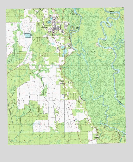
Wewahitchka, FL USGS Topographic Map
Click on map above to begin viewing in our Map Viewer.

This topographic map contains these locations and features:
Feature Name Type Latitude Longitude GNIS ID View Map
Boggy JordanSwampN30.0188°W85.1326°279173View Map
Bryants LandingLocaleN30.0171°W85.1466°295158View Map
Burgess CreekGutN30.0455°W85.1699°294632View Map
Burgess LandingLocaleN30.0410°W85.1696°295164View Map
Church of ChristChurchN30.1099°W85.2013°301778View Map
City of WewahitchkaCivilN30.1153°W85.1932°2405724View Map
Cochran LandingLocaleN30.1005°W85.1816°295208View Map
Cochran SloughStreamN30.1019°W85.1819°304842View Map
Corley SloughGutN30.0844°W85.1605°280849View Map
Cutoff IslandSwampN30.0803°W85.1530°305538View Map
DalkeithPopulated PlaceN30.0058°W85.1541°295235View Map
Dalkeith ChurchChurchN30.0155°W85.1591°304846View Map
Dalkeith Fire DepartmentBuildingN30.0105°W85.1557°2644326View Map
Double PointsBendN30.0413°W85.1296°304849View Map
Douglas LandingLocaleN30.0113°W85.1332°295246View Map
First United Pentecostal ChurchChurchN30.1085°W85.1999°301777View Map
Gaskins StillPopulated PlaceN30.0383°W85.1813°282960View Map
Grayson SloughStreamN30.1233°W85.1253°304829View Map
Gulf County Sheriff's OfficeBuildingN30.1158°W85.1991°2754469View Map
Gum Drift SloughGutN30.0694°W85.1724°283537View Map
HoneyvillePopulated PlaceN30.0580°W85.1899°284231View Map
Lake AliceLakeN30.1155°W85.2020°294631View Map
Lake ComaLakeN30.0896°W85.1980°294634View Map
Lake GrovePopulated PlaceN30.1202°W85.1769°304845View Map
Lake GrovePopulated PlaceN30.1188°W85.1752°283473View Map
Lake JuliaLakeN30.1126°W85.2045°294636View Map
Lake ShippeyLakeN30.0926°W85.2001°294639View Map
Lands LakeLakeN30.0855°W85.1875°304838View Map
Listers LandingLocaleN30.0083°W85.1260°304847View Map
Lockey LakeLakeN30.0183°W85.1487°285906View Map
Louisa BendBendN30.1071°W85.1394°286132View Map
Magnolia SloughChannelN30.0921°W85.1746°286307View Map
Moccasin SloughStreamN30.1146°W85.1369°295794View Map
Piney Reach SloughGutN30.0260°W85.1332°288967View Map
Post Office PointBendN30.0252°W85.1444°304848View Map
Red Bull IslandIslandN30.1066°W85.1794°289541View Map
River StyxStreamN30.0844°W85.1355°306457View Map
Roberts CemeteryCemeteryN30.0571°W85.1810°294635View Map
Roberts SloughGutN30.0571°W85.1696°289791View Map
Robertson CemeteryCemeteryN30.0202°W85.1655°304839View Map
Saint Lawrence ChurchChurchN30.1233°W85.1988°304844View Map
Schoolhouse BranchSwampN30.1016°W85.1941°295813View Map
Sheep IslandsIslandN30.0671°W85.2177°290958View Map
T L James ParkParkN30.0996°W85.2094°304841View Map
Tom Smith BranchChannelN30.0746°W85.2013°292338View Map
Upper Piney ReachChannelN30.0555°W85.1360°292709View Map
Van Horn SloughGutN30.0480°W85.1463°292732View Map
Virginia CutStreamN30.0449°W85.1585°292781View Map
West Side ChurchChurchN30.1094°W85.2102°304843View Map
WewahitchkaPopulated PlaceN30.1127°W85.2005°294641View Map
Wewahitchka Elementary SchoolSchoolN30.1051°W85.1941°297869View Map
Wewahitchka Emergency Medical ServicesBuildingN30.1061°W85.2020°2661739View Map
Wewahitchka Junior-Senior High SchoolSchoolN30.1066°W85.2007°297870View Map
Wewahitchka Post OfficePost OfficeN30.1148°W85.2053°2783457View Map
Whites RiverStreamN30.0799°W85.1680°293245View Map
Williamsburg CemeteryCemeteryN30.1127°W85.2163°304840View Map

Note: Coordinates in the location and feature list above are referenced to NAD83 datum.


Copyright (C) 2008-2024 Ryan Niemi / Sunset Dynamics ... All Rights Reserved