TopoQuest Logo
Do you find TopoQuest useful?
Help keep TopoQuest running and adding new maps/features by donating!
Bitcoin:  19c7KJd3qBynnjoSw5npx9KScwjBe4ifkT
Litecoin:  LXs6TkuXGGXo1vDsWCkWVdjQX94eUKd6ui
Home View Maps Find Maps Find Places Resources & Links


Kennedy Creek, Florida Topographic Map

USGS Map Title: Kennedy Creek, FL
USGS Map MRC: 30085A1
DRG (GeoTIFF) Download: o30085a1.tif


Neighboring USGS Topographic Map Quads:


  Dead Lakes, FL  
30085B2
 

  Orange, FL  
30085B1
 

  Wilma, FL  
30084B8
 

  Wewahitchka, FL  
30085A2
 

  Kennedy Creek, FL  
30085A1
 

  Sumatra, FL  
30084A8


Map MRC Location:

N31°
W86°
N31°
W85°
H8 H7 H6 H5 H4 H3 H2 H1
G8 G7 G6 G5 G4 G3 G2 G1
F8 F7 F6 F5 F4 F3 F2 F1
E8 E7 E6 E5 E4 E3 E2 E1
D8 D7 D6 D5 D4 D3 D2 D1
C8 C7 C6 C5 C4 C3 C2 C1
B8 B7 B6 B5 B4 B3 B2 B1
A8 A7 A6 A5 A4 A3 A2 A1
N30°
W86°
N30°
W85°

Kennedy Creek, FL USGS 1:24K Topographic Map Preview:
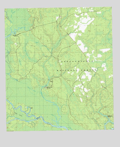
Kennedy Creek, FL USGS Topographic Map
Click on map above to begin viewing in our Map Viewer.

This topographic map contains these locations and features:
Feature Name Type Latitude Longitude GNIS ID View Map
Alligator CreekStreamN30.1238°W85.1132°305206View Map
Battle BendBendN30.0249°W85.0977°304735View Map
Big Cypress SwampSwampN30.0789°W85.0990°305294View Map
Bird BaySwampN30.0394°W85.0498°305313View Map
Black CreekStreamN30.0071°W85.0046°305319View Map
Bucks BightBendN30.0085°W85.1230°304734View Map
Chipola RiverStreamN30.0119°W85.0913°305475View Map
Cotton LandingLocaleN30.0516°W85.0732°305507View Map
Cotton Landing CampgroundLocaleN30.0524°W85.0716°307003View Map
Douglas SloughStreamN30.0138°W85.1135°305595View Map
Escambia (historical)Populated PlaceN30.0502°W85.0499°306989View Map
Fields BranchStreamN30.0530°W85.0735°305666View Map
Fields LakeLakeN30.0531°W85.1132°305667View Map
Graveyard Pole LookoutLocaleN30.1035°W85.0938°305757View Map
Hathcock BaySwampN30.0919°W85.0910°305796View Map
Hosford PondSwampN30.0707°W85.1079°305836View Map
Kennedy CreekStreamN30.0049°W85.0624°305901View Map
Kennedy Creek Fish CampLocaleN30.0446°W85.0780°306103View Map
Kennedy SloughStreamN30.0085°W85.0644°304733View Map
Little Owl CreekStreamN30.0191°W85.0177°305967View Map
Lower Piney ReachChannelN30.0305°W85.1213°305993View Map
Owl LandingPopulated PlaceN30.0183°W85.0160°306183View Map
Owl LandingLocaleN30.0121°W85.0057°307004View Map
Post Office BaySwampN30.0873°W85.0015°306254View Map
Rooted DevilChannelN30.0758°W85.0766°306305View Map
Rowletts CreekStreamN30.0183°W85.0174°305193View Map
Salters BranchStreamN30.0785°W85.0707°304739View Map
Salty BranchStreamN30.0433°W85.0835°306340View Map
Shephard LakeLakeN30.0571°W85.1197°306379View Map
Shephard SloughGutN30.0405°W85.0966°306380View Map
Solomon LakeLakeN30.0669°W85.1202°304737View Map
Spiders GutGutN30.0074°W85.0921°304736View Map
Swift SloughGutN30.1088°W85.1185°306477View Map
Turner LakeLakeN30.0792°W85.1210°304738View Map
White Oak LandingPopulated PlaceN30.0983°W85.1130°306591View Map
WHite Oak Landing CampgroundLocaleN30.0977°W85.1127°307007View Map
Wright LakeLakeN30.0010°W85.0015°306617View Map
Wright Lake Recreation SiteLocaleN30.0019°W85.0027°307005View Map

Note: Coordinates in the location and feature list above are referenced to NAD83 datum.


Copyright (C) 2008-2025 Ryan Niemi / Sunset Dynamics ... All Rights Reserved