TopoQuest Logo
Do you find TopoQuest useful?
Help keep TopoQuest running and adding new maps/features by donating!
Bitcoin:  19c7KJd3qBynnjoSw5npx9KScwjBe4ifkT
Litecoin:  LXs6TkuXGGXo1vDsWCkWVdjQX94eUKd6ui
Home View Maps Find Maps Find Places Resources & Links


Whately, Montana Topographic Map

USGS Map Title: Whately, MT
USGS Map MRC: 48106B5
DRG (GeoTIFF) Download: o48106b5.tif


Neighboring USGS Topographic Map Quads:


  Chapman Coulee, MT  
48106C6
 

  Hawk Coulee, MT  
48106C5
 

  Uhlan Coulee, MT  
48106C4
 

  Glasgow, MT  
48106B6
 

  Whately, MT  
48106B5
 

  Lindeke Coulee, MT  
48106B4
 

  Blanchard Ranch, MT  
48106A6
 

  Wheeler, MT  
48106A5
 

  Fort Peck, MT  
48106A4


Map MRC Location:

N49°
W107°
N49°
W106°
H8 H7 H6 H5 H4 H3 H2 H1
G8 G7 G6 G5 G4 G3 G2 G1
F8 F7 F6 F5 F4 F3 F2 F1
E8 E7 E6 E5 E4 E3 E2 E1
D8 D7 D6 D5 D4 D3 D2 D1
C8 C7 C6 C5 C4 C3 C2 C1
B8 B7 B6 B5 B4 B3 B2 B1
A8 A7 A6 A5 A4 A3 A2 A1
N48°
W107°
N48°
W106°

Whately, MT USGS 1:24K Topographic Map Preview:
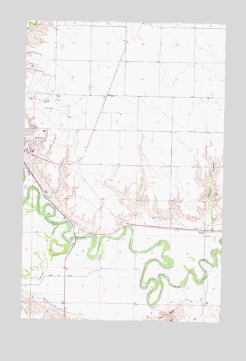
Whately, MT USGS Topographic Map
Click on map above to begin viewing in our Map Viewer.

This topographic map contains these locations and features:
Feature Name Type Latitude Longitude GNIS ID View Map
27N40E06CDCD01 WellWellN48.1314°W106.6048°826542View Map
28N40E15DDAB01 WellWellN48.1789°W106.5348°1633871View Map
28N40E22CABC01 WellWellN48.1672°W106.5489°1633790View Map
28N40E31CCBA01 WellWellN48.1350°W106.6178°826580View Map
28N40E31CCBD01 WellWellN48.1347°W106.6181°826578View Map
28N40E31CDCD01 WellWellN48.1328°W106.6128°826556View Map
Centennial ParkParkN48.1978°W106.6200°1819494View Map
Dogie CreekStreamN48.1414°W106.5120°770709View Map
Evangelical ChurchChurchN48.2045°W106.6153°1677292View Map
Glasgow Army Air Field (historical)MilitaryN48.2164°W106.6153°2092038View Map
Glasgow High SchoolSchoolN48.2039°W106.6131°1819497View Map
Glasgow Highland CemeteryCemeteryN48.2002°W106.6222°771794View Map
Glasgow Middle SchoolSchoolN48.1956°W106.6181°1819576View Map
Glasgow Stock Yards (historical)LocaleN48.1886°W106.6225°1688534View Map
Goudge CouleeValleyN48.1653°W106.5495°1677339View Map
Hanson DamDamN48.2434°W106.5539°796124View Map
Joy FellowshipChurchN48.1959°W106.6248°1677290View Map
Milk River BridgeBridgeN48.1514°W106.5117°1819593View Map
Reorganized Church of Jesus Christ of Latter Day SaintsChurchN48.1995°W106.6198°1677291View Map
Scottie FieldParkN48.2042°W106.6117°1819493View Map
Shady Rest RV ParkLocaleN48.1953°W106.6223°1677328View Map
Smith Clinic ParkParkN48.1959°W106.6231°1819495View Map
Sullivan ParkParkN48.1853°W106.6217°1819486View Map
Tiger ButteSummitN48.1253°W106.5323°777640View Map
Valley County Long Run Fire DepartmentBuildingN48.1960°W106.6214°1688573View Map
Vandalia South CanalCanalN48.1284°W106.5950°778002View Map
WhatelyPopulated PlaceN48.1628°W106.5114°778335View Map
Whately (historical)LocaleN48.1628°W106.5117°1819599View Map
Whately CouleeValleyN48.1647°W106.5064°778336View Map
Whately Post Office (historical)Post OfficeN48.1628°W106.5117°1819600View Map
Willow CreekStreamN48.1572°W106.5953°778542View Map

Note: Coordinates in the location and feature list above are referenced to NAD83 datum.


Copyright (C) 2008-2025 Ryan Niemi / Sunset Dynamics ... All Rights Reserved