TopoQuest Logo
Do you find TopoQuest useful?
Help keep TopoQuest running and adding new maps/features by donating!
Bitcoin:  19c7KJd3qBynnjoSw5npx9KScwjBe4ifkT
Litecoin:  LXs6TkuXGGXo1vDsWCkWVdjQX94eUKd6ui
Home View Maps Find Maps Find Places Resources & Links


Wheelersburg, Ohio Topographic Map

USGS Map Title: Wheelersburg, OH
USGS Map MRC: 38082F7
DRG (GeoTIFF) Download: o38082f7.tif


Neighboring USGS Topographic Map Quads:


  New Boston, OH  
38082G8
 

  Minford, OH  
38082G7
 

  South Webster, OH  
38082G6
 

  Portsmouth, OH  
38082F8
 

  Wheelersburg, OH  
38082F7
 

  Pedro, OH  
38082F6
 

  Load, KY  
38082E8
 

  Greenup, KY  
38082E7
 

  Ironton, OH  
38082E6


Map MRC Location:

N39°
W83°
N39°
W82°
H8 H7 H6 H5 H4 H3 H2 H1
G8 G7 G6 G5 G4 G3 G2 G1
F8 F7 F6 F5 F4 F3 F2 F1
E8 E7 E6 E5 E4 E3 E2 E1
D8 D7 D6 D5 D4 D3 D2 D1
C8 C7 C6 C5 C4 C3 C2 C1
B8 B7 B6 B5 B4 B3 B2 B1
A8 A7 A6 A5 A4 A3 A2 A1
N38°
W83°
N38°
W82°

Wheelersburg, OH USGS 1:24K Topographic Map Preview:
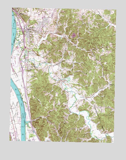
Wheelersburg, OH USGS Topographic Map
Click on map above to begin viewing in our Map Viewer.

This topographic map contains these locations and features:
Feature Name Type Latitude Longitude GNIS ID View Map
Able Medical TransportBuildingN38.7333°W82.8587°2550741View Map
AllentownPopulated PlaceN38.6962°W82.8582°1075255View Map
Angel HollowValleyN38.6892°W82.7996°1075266View Map
Ball School (historical)SchoolN38.6776°W82.8560°1049557View Map
Blair QuarryMineN38.7039°W82.8583°2633268View Map
Brick Union ChurchChurchN38.6437°W82.8729°487881View Map
Burkes LandingLocaleN38.6826°W82.8732°1049556View Map
Cadot HillSummitN38.7190°W82.7557°1075502View Map
Chandlers RunStreamN38.6434°W82.8554°1075559View Map
Coyle HollowValleyN38.6406°W82.7832°1049547View Map
Crestview ParkPopulated PlaceN38.7436°W82.8431°2568279View Map
Dark Lick School (historical)SchoolN38.6367°W82.7738°1049545View Map
Dogwood RidgeRidgeN38.7387°W82.8313°1075730View Map
Dogwood Ridge School (historical)SchoolN38.7492°W82.8363°1049551View Map
Dold CemeteryCemeteryN38.6995°W82.8091°1075732View Map
Elm Grove School (historical)SchoolN38.6865°W82.8199°1049549View Map
Empire School (historical)SchoolN38.6801°W82.7577°1049543View Map
Feurt CemeteryCemeteryN38.6381°W82.8446°1075844View Map
Floral Hills Memory Gardens CemeteryCemeteryN38.6856°W82.8521°1075862View Map
Folsoms LandingLocaleN38.6265°W82.8554°1049366View Map
Franklin FurnacePopulated PlaceN38.6451°W82.8488°1075237View Map
Franklin Furnace LandingLocaleN38.6412°W82.8557°1049558View Map
Franklin Furnace Post OfficePost OfficeN38.6451°W82.8485°2044065View Map
Franklin HollowValleyN38.6470°W82.8316°1075875View Map
Garden CityPopulated PlaceN38.7079°W82.8538°1075892View Map
Gerlach CemeteryCemeteryN38.6642°W82.8504°1075902View Map
Germany HollowValleyN38.7170°W82.7971°1075911View Map
Germany Hollow ChurchChurchN38.7212°W82.7960°1075912View Map
Goose CreekStreamN38.6917°W82.8135°1075937View Map
Grays BranchStreamN38.6620°W82.8643°493212View Map
Grays Branch SchoolSchoolN38.6326°W82.8699°493213View Map
Green Township School (historical)SchoolN38.6664°W82.7844°2559242View Map
Green Township Volunteer Fire Department Station 2BuildingN38.6628°W82.8066°2550335View Map
Greenup Locks and DamDamN38.6479°W82.8609°517167View Map
Happy HollowValleyN38.6745°W82.8546°1076000View Map
Hayport School (historical)SchoolN38.6962°W82.8741°1049555View Map
Highland ParkPopulated PlaceN38.6351°W82.8477°1076048View Map
Hillcrest Childrens HomeBuildingN38.7198°W82.8518°1076051View Map
Irish HollowValleyN38.6554°W82.7507°1076116View Map
Junior Bridge School (historical)SchoolN38.6542°W82.8016°1049544View Map
Lick RunStreamN38.7017°W82.8466°1066374View Map
Lick Run Lick RunStreamN38.7015°W82.8463°1076249View Map
Lick Run School (historical)SchoolN38.7262°W82.8196°1049541View Map
Lloyd Census Designated PlaceCensusN38.6315°W82.8665°2629641View Map
Memorial Burial ParkCemeteryN38.7123°W82.8513°1076377View Map
Mount Carmel ChurchChurchN38.6384°W82.7893°1076444View Map
North Fork Lick RunStreamN38.7162°W82.7985°1066378View Map
Nurse CemeteryCemeteryN38.6906°W82.8546°1076533View Map
Old Dutch CemeteryCemeteryN38.7273°W82.8221°1076556View Map
Old Wheelersburg CemeteryCemeteryN38.7365°W82.8557°1964263View Map
Pine CreekStreamN38.7276°W82.8691°1076632View Map
Pine Creek Baptist CemeteryCemeteryN38.6840°W82.8174°1964264View Map
Pine Creek ChurchChurchN38.6842°W82.8163°1076637View Map
Pitch BranchStreamN38.6576°W82.8682°500772View Map
Poplar Fork Pine CreekStreamN38.6701°W82.7968°1076673View Map
Porter Township Emergency Rescue AssociationBuildingN38.7302°W82.8539°2550865View Map
Porter Township Fire DepartmentBuildingN38.7303°W82.8530°2549303View Map
Possum HollowValleyN38.7042°W82.8360°1076680View Map
PowellsvillePopulated PlaceN38.6667°W82.7835°1076685View Map
Powellsville Baptist CemeteryCemeteryN38.6648°W82.7896°1964266View Map
Powellsville Post Office (historical)Post OfficeN38.6667°W82.7832°2043965View Map
Prestons LandingLocaleN38.7087°W82.8738°1049554View Map
Railpike HollowValleyN38.6473°W82.7788°1049546View Map
Rawley CemeteryCemeteryN38.7467°W82.8682°1076716View Map
Riepenhoff HollowValleyN38.7254°W82.8124°1049540View Map
Sager HollowValleyN38.6504°W82.7924°1049548View Map
Saint John Lutheran ChurchChurchN38.6648°W82.7893°1063899View Map
Salladay CemeteryCemeteryN38.6926°W82.8521°1076812View Map
Sand HillPopulated PlaceN38.6956°W82.8552°1076820View Map
Scioto Ambulance District Squad 9BuildingN38.7376°W82.7548°2550888View Map
Sheldon RunStreamN38.6837°W82.8143°1076879View Map
Slash BranchStreamN38.6417°W82.8718°503629View Map
Smithline HollowValleyN38.6287°W82.8127°1076925View Map
Sperry ForkStreamN38.6304°W82.7529°1076944View Map
Stewart HollowValleyN38.7445°W82.8654°1076969View Map
Sugar Camp CreekStreamN38.7265°W82.8249°1076987View Map
Sugarcamp BranchStreamN38.6748°W82.8721°504692View Map
Sun HillSummitN38.7404°W82.8593°1076999View Map
Terrapin HollowValleyN38.7356°W82.7571°1077035View Map
Tick HollowValleyN38.6998°W82.7974°1077047View Map
Tick RidgeRidgeN38.6576°W82.8154°1049550View Map
Township of GreenCivilN38.6354°W82.8101°1086925View Map
Township of PorterCivilN38.7347°W82.8447°1086932View Map
Township of VernonCivilN38.7225°W82.7514°1086938View Map
Upper Lick Run School (historical)SchoolN38.7140°W82.7921°1049542View Map
Vernon Township Fire Station 1BuildingN38.7376°W82.7548°2550347View Map
WheelersburgPopulated PlaceN38.7304°W82.8554°1077173View Map
Wheelersburg Census Designated PlaceCensusN38.7383°W82.8421°2393849View Map
Wheelersburg Elementary SchoolSchoolN38.7412°W82.8385°1049552View Map
Wheelersburg High SchoolSchoolN38.7265°W82.8504°1049553View Map
Wheelersburg Post OfficePost OfficeN38.7306°W82.8554°2044064View Map

Note: Coordinates in the location and feature list above are referenced to NAD83 datum.


Copyright (C) 2008-2024 Ryan Niemi / Sunset Dynamics ... All Rights Reserved