TopoQuest Logo
Do you find TopoQuest useful?
Help keep TopoQuest running and adding new maps/features by donating!
Bitcoin:  19c7KJd3qBynnjoSw5npx9KScwjBe4ifkT
Litecoin:  LXs6TkuXGGXo1vDsWCkWVdjQX94eUKd6ui
Home View Maps Find Maps Find Places Resources & Links


South Webster, Ohio Topographic Map

USGS Map Title: South Webster, OH
USGS Map MRC: 38082G6
DRG (GeoTIFF) Download: o38082g6.tif


Neighboring USGS Topographic Map Quads:


  Stockdale, OH  
38082H7
 

  Petersburg, OH  
38082H6
 

  Oak Hill, OH  
38082H5
 

  Minford, OH  
38082G7
 

  South Webster, OH  
38082G6
 

  Gallia, OH  
38082G5
 

  Wheelersburg, OH  
38082F7
 

  Pedro, OH  
38082F6
 

  Sherritts, OH  
38082F5


Map MRC Location:

N39°
W83°
N39°
W82°
H8 H7 H6 H5 H4 H3 H2 H1
G8 G7 G6 G5 G4 G3 G2 G1
F8 F7 F6 F5 F4 F3 F2 F1
E8 E7 E6 E5 E4 E3 E2 E1
D8 D7 D6 D5 D4 D3 D2 D1
C8 C7 C6 C5 C4 C3 C2 C1
B8 B7 B6 B5 B4 B3 B2 B1
A8 A7 A6 A5 A4 A3 A2 A1
N38°
W83°
N38°
W82°

South Webster, OH USGS 1:24K Topographic Map Preview:
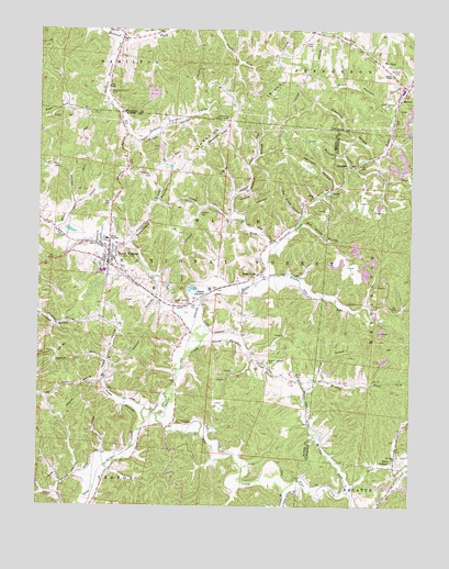
South Webster, OH USGS Topographic Map
Click on map above to begin viewing in our Map Viewer.

This topographic map contains these locations and features:
Feature Name Type Latitude Longitude GNIS ID View Map
Barnhart HollowValleyN38.8398°W82.6457°1075309View Map
Bloom Furnace (historical)LocaleN38.7865°W82.6724°1049396View Map
Bloom Furnace CemeteryCemeteryN38.7878°W82.6727°1075407View Map
Bloom Furnace CreekStreamN38.7920°W82.6960°1075408View Map
Bloom High SchoolSchoolN38.8201°W82.7271°1075409View Map
Bloom JunctionPopulated PlaceN38.8059°W82.6927°1075410View Map
Bloom Switch CemeteryCemeteryN38.8037°W82.7046°1075411View Map
Bloom Township CemeteryCemeteryN38.8092°W82.7149°1077336View Map
Brady CemeteryCemeteryN38.8115°W82.6632°1964254View Map
Brady RunStreamN38.8084°W82.6777°1075435View Map
Brant CemeteryCemeteryN38.7845°W82.6638°1075439View Map
Brushy ForkStreamN38.7548°W82.6463°1075459View Map
Diamond HollowValleyN38.8426°W82.6382°1075711View Map
Dutch HollowValleyN38.8729°W82.7227°1075757View Map
EifortPopulated PlaceN38.8334°W82.6529°1075787View Map
Eifort ChurchChurchN38.8309°W82.6577°1075788View Map
Eifort Post Office (historical)Post OfficeN38.8334°W82.6527°2044031View Map
FirebrickPopulated PlaceN38.8392°W82.6454°1075850View Map
Firebrick Post Office (historical)Post OfficeN38.8390°W82.6457°2025787View Map
Fisher School (historical)SchoolN38.7701°W82.6918°1049398View Map
Globe Switch (historical)LocaleN38.8254°W82.6624°1049395View Map
Hales CreekStreamN38.7740°W82.7099°1075982View Map
Hales CreekPopulated PlaceN38.8112°W82.6754°1075983View Map
Hales Creek Post Office (historical)Post OfficeN38.8112°W82.6749°2043958View Map
Harrison HollowValleyN38.8345°W82.6504°1076017View Map
Hawkins HollowValleyN38.7834°W82.6535°1076027View Map
Hope HollowValleyN38.7751°W82.7160°1076075View Map
Hope School (historical)SchoolN38.7940°W82.7243°1049401View Map
Jackson ForkStreamN38.8179°W82.6702°1076126View Map
Jackson Furnace CemeteryCemeteryN38.8592°W82.7254°1076127View Map
Jackson Furnace CreekStreamN38.8731°W82.7229°1076128View Map
Jackson Furnace School (historical)SchoolN38.8481°W82.7213°1049400View Map
Johnson CemeteryCemeteryN38.7687°W82.6963°1076151View Map
Madland (historical)Populated PlaceN38.7634°W82.6818°1049397View Map
Madland Post Office (historical)Post OfficeN38.7640°W82.6818°2044044View Map
MonroePopulated PlaceN38.8565°W82.6291°1076418View Map
Monroe CemeteryCemeteryN38.8648°W82.6296°1076420View Map
Monroe ChapelChurchN38.8631°W82.6318°1076422View Map
Monroe HollowValleyN38.8629°W82.6257°1076423View Map
Mount Olive ChurchChurchN38.7629°W82.6296°1076452View Map
New Globe HollowValleyN38.8237°W82.6610°1076506View Map
Old Globe HollowValleyN38.8265°W82.6627°1076558View Map
Olive CreekStreamN38.7537°W82.6454°1077270View Map
Olive FurnacePopulated PlaceN38.7617°W82.6299°1076573View Map
Olive Furnace Post Office (historical)Post OfficeN38.7612°W82.6304°2026004View Map
Pine Creek ChapelChurchN38.7717°W82.6982°1076636View Map
Rayburn HollowValleyN38.7640°W82.7279°1076717View Map
Rhoden HollowValleyN38.8276°W82.6852°1076730View Map
Scioto Ambulance District Squad 7BuildingN38.8155°W82.7262°2550898View Map
Simmering Lookout TowerTowerN38.8512°W82.6866°1085228View Map
Simmering RidgeRidgeN38.8545°W82.6807°1076896View Map
Slab HollowValleyN38.8531°W82.6327°1076909View Map
Slab Hollow CemeteryCemeteryN38.8553°W82.6327°1076910View Map
South WebsterPopulated PlaceN38.8134°W82.7268°1084066View Map
South Webster Bloom Township Fire DepartmentBuildingN38.8156°W82.7262°2550376View Map
South Webster CemeteryCemeteryN38.8092°W82.7152°1964268View Map
South Webster Elementary SchoolSchoolN38.8201°W82.7274°1049399View Map
South Webster Post OfficePost OfficeN38.8140°W82.7263°2044062View Map
South Webster ReservoirReservoirN38.8223°W82.7394°1078121View Map
South Webster Reservoir DamDamN38.8234°W82.7416°1078120View Map
Stidham CemeteryCemeteryN38.8267°W82.6960°1076971View Map
Sugar Camp HollowValleyN38.8190°W82.7199°1085489View Map
Township of BloomCivilN38.8079°W82.7251°1086922View Map
Village of South WebsterCivilN38.8170°W82.7282°2399861View Map
White Bear School (historical)SchoolN38.8434°W82.6679°1049394View Map
Youngs BranchStreamN38.7534°W82.6668°1077247View Map

Note: Coordinates in the location and feature list above are referenced to NAD83 datum.


Copyright (C) 2008-2025 Ryan Niemi / Sunset Dynamics ... All Rights Reserved