TopoQuest Logo
Do you find TopoQuest useful?
Help keep TopoQuest running and adding new maps/features by donating!
Bitcoin:  19c7KJd3qBynnjoSw5npx9KScwjBe4ifkT
Litecoin:  LXs6TkuXGGXo1vDsWCkWVdjQX94eUKd6ui
Home View Maps Find Maps Find Places Resources & Links


White City, Tennessee Topographic Map

USGS Map Title: White City, TN
USGS Map MRC: 35085B6
DRG (GeoTIFF) Download: o35085b6.tif


Neighboring USGS Topographic Map Quads:


  Burrow Cove, TN  
35085C7
 

  Tracy City, TN  
35085C6
 

  Palmer, TN  
35085C5
 

  Monteagle, TN  
35085B7
 

  White City, TN  
35085B6
 

  Whitwell, TN  
35085B5
 

  Orme, TN  
35085A7
 

  South Pittsburg, TN  
35085A6
 

  Sequatchie, TN  
35085A5


Map MRC Location:

N36°
W86°
N36°
W85°
H8 H7 H6 H5 H4 H3 H2 H1
G8 G7 G6 G5 G4 G3 G2 G1
F8 F7 F6 F5 F4 F3 F2 F1
E8 E7 E6 E5 E4 E3 E2 E1
D8 D7 D6 D5 D4 D3 D2 D1
C8 C7 C6 C5 C4 C3 C2 C1
B8 B7 B6 B5 B4 B3 B2 B1
A8 A7 A6 A5 A4 A3 A2 A1
N35°
W86°
N35°
W85°

White City, TN USGS 1:24K Topographic Map Preview:
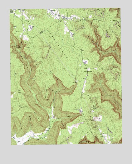
White City, TN USGS Topographic Map
Click on map above to begin viewing in our Map Viewer.

This topographic map contains these locations and features:
Feature Name Type Latitude Longitude GNIS ID View Map
Anderson CoveValleyN35.1292°W85.7427°1275713View Map
Anderson PointCapeN35.1676°W85.7105°1275727View Map
Bell BranchStreamN35.1992°W85.7291°1276899View Map
Big RidgeRidgeN35.1556°W85.6572°1277358View Map
ComfortPopulated PlaceN35.1276°W85.7422°1314874View Map
Commissioner District 2CivilN35.1624°W85.7453°2463951View Map
Denny CoveValleyN35.1463°W85.7012°1282346View Map
Denny Cove BranchStreamN35.1440°W85.7061°1647272View Map
Elisons Mill (historical)LocaleN35.2059°W85.6722°1310008View Map
Ellidge PointCapeN35.1476°W85.7180°1283662View Map
Foster FallsFallsN35.1817°W85.6758°1284701View Map
Foster Falls SchoolSchoolN35.1915°W85.6633°1284702View Map
Foster Falls Volunteer Fire DepartmentBuildingN35.1622°W85.6707°2654843View Map
Fosters Mill (historical)LocaleN35.1823°W85.6764°1310009View Map
Gregg CemeteryCemeteryN35.2340°W85.7247°1286232View Map
Haskell Foster LakeReservoirN35.2301°W85.6816°1301668View Map
Haskell Foster Lake DamDamN35.2301°W85.6816°1301667View Map
Higgins RidgeRidgeN35.2248°W85.6400°1287689View Map
Jasper Fire TowerBuildingN35.1581°W85.6556°2654554View Map
Lankford TownPopulated PlaceN35.2495°W85.7372°1315352View Map
Laurel BranchStreamN35.1759°W85.6952°1290690View Map
Lick HollowValleyN35.1472°W85.6941°1291228View Map
Little CoveValleyN35.1950°W85.7267°1291433View Map
Little Gizzard CreekStreamN35.1520°W85.7061°1291512View Map
Little Indian CreekStreamN35.2170°W85.6516°1291542View Map
Long BranchStreamN35.2095°W85.6311°1291868View Map
Long RidgeRidgeN35.2334°W85.6280°1291999View Map
Marshal Meeks Number 3 MineMineN35.1634°W85.6539°1650207View Map
McAlloyd BranchStreamN35.2109°W85.7394°1293073View Map
North Fork Pryor Cove BranchStreamN35.1251°W85.6619°1269834View Map
Oak GrovePopulated PlaceN35.2409°W85.6891°1315615View Map
Oak Grove CemeteryCemeteryN35.2409°W85.6902°1317589View Map
Pine Set School (historical)SchoolN35.1381°W85.7102°1310076View Map
Pineset Baptist ChurchChurchN35.1326°W85.7280°1314240View Map
Plummeting SpringsSpringN35.1401°W85.7380°1643737View Map
Pryor RidgeRidgeN35.2495°W85.6508°1298641View Map
Pryor Ridge School (historical)SchoolN35.2404°W85.6691°1310078View Map
Pyburn PlaceLocaleN35.1851°W85.7239°1315777View Map
Pyror Ridge Methodist ChurchChurchN35.2412°W85.6791°1317598View Map
Raven PointCapeN35.2154°W85.7402°1298973View Map
Robinson CoveValleyN35.1558°W85.7043°1299700View Map
Sams BranchStreamN35.2170°W85.6516°1300639View Map
Sides PlaceLocaleN35.2151°W85.7280°1314287View Map
Speegle CoveValleyN35.1379°W85.7294°1270975View Map
Speegle PointCapeN35.1473°W85.7394°1270976View Map
Sugarcamp HollowValleyN35.1734°W85.7003°1271711View Map
White CityPopulated PlaceN35.2473°W85.7027°1274362View Map

Note: Coordinates in the location and feature list above are referenced to NAD83 datum.


Copyright (C) 2008-2025 Ryan Niemi / Sunset Dynamics ... All Rights Reserved