TopoQuest Logo
Do you find TopoQuest useful?
Help keep TopoQuest running and adding new maps/features by donating!
Bitcoin:  19c7KJd3qBynnjoSw5npx9KScwjBe4ifkT
Litecoin:  LXs6TkuXGGXo1vDsWCkWVdjQX94eUKd6ui
Home View Maps Find Maps Find Places Resources & Links


Orme, Tennessee Topographic Map

USGS Map Title: Orme, TN
USGS Map MRC: 35085A7
DRG (GeoTIFF) Download: o35085a7.tif


Neighboring USGS Topographic Map Quads:


  Sewanee, TN  
35085B8
 

  Monteagle, TN  
35085B7
 

  White City, TN  
35085B6
 

  Sinking Cove, TN  
35085A8
 

  Orme, TN  
35085A7
 

  South Pittsburg, TN  
35085A6
 

  Eureka, AL  
34085H8
 

  Doran Cove, AL  
34085H7
 

  Bridgeport, AL  
34085H6


Map MRC Location:

N36°
W86°
N36°
W85°
H8 H7 H6 H5 H4 H3 H2 H1
G8 G7 G6 G5 G4 G3 G2 G1
F8 F7 F6 F5 F4 F3 F2 F1
E8 E7 E6 E5 E4 E3 E2 E1
D8 D7 D6 D5 D4 D3 D2 D1
C8 C7 C6 C5 C4 C3 C2 C1
B8 B7 B6 B5 B4 B3 B2 B1
A8 A7 A6 A5 A4 A3 A2 A1
N35°
W86°
N35°
W85°

Orme, TN USGS 1:24K Topographic Map Preview:
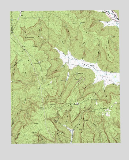
Orme, TN USGS Topographic Map
Click on map above to begin viewing in our Map Viewer.

This topographic map contains these locations and features:
Feature Name Type Latitude Longitude GNIS ID View Map
Ballard PointCapeN35.0909°W85.7933°1276243View Map
Battle Creek MinesMineN35.0315°W85.7894°1309993View Map
Battle Creek MinesMineN35.0312°W85.8119°1309994View Map
Beene CemeteryCemeteryN35.0773°W85.7908°1276879View Map
Beene CoveValleyN35.0777°W85.7938°1276880View Map
Beene Cove BranchStreamN35.0762°W85.7961°1647270View Map
Billy Goat CliffCliffN35.0129°W85.7933°1277472View Map
Bolten MinesMineN35.0620°W85.7914°1309997View Map
Bolton PointCapeN35.0617°W85.7916°1277914View Map
Cave SpringSpringN35.0776°W85.8420°1279942View Map
Chitty CoveValleyN35.0035°W85.7506°1280494View Map
Clayton Camp BranchStreamN35.0165°W85.8119°1305949View Map
Collins CoveValleyN35.1024°W85.8397°1269481View Map
Commissioner District 1CivilN35.0399°W85.7641°2464263View Map
Crooked Tree HollowValleyN35.0598°W85.8722°1281682View Map
Deerstand HillSummitN35.0331°W85.7703°1282307View Map
Dogwood SpringSpringN35.0369°W85.8296°1282615View Map
Falling CliffCliffN35.0290°W85.8589°1284089View Map
Fishtrap PointCapeN35.0773°W85.7589°1284330View Map
Franklin-Marion State ForestForestN35.0948°W85.8528°1284835View Map
Gilliam CoveValleyN35.0636°W85.7758°1285410View Map
Goardneck Cove BranchStreamN35.0790°W85.8050°1650195View Map
Goat RockPillarN35.0967°W85.7619°1285549View Map
Gourdneck CoveValleyN35.0748°W85.8062°1285759View Map
Holly SpringSpringN35.0327°W85.8406°1288109View Map
Horseshoe PointCapeN35.0376°W85.8594°1288454View Map
Hotel PointCapeN35.0629°W85.8550°1288482View Map
Jackson PointCapeN35.1004°W85.7541°1289241View Map
Kelley CoveValleyN35.0590°W85.7678°1290004View Map
Kelly Cove BranchStreamN35.0634°W85.7694°1647276View Map
LodgeLocaleN35.0745°W85.8036°1291805View Map
Lous ChapelChurchN35.1234°W85.7641°1314137View Map
Main CoveValleyN35.0809°W85.8113°1292514View Map
Nancy Winn CoveValleyN35.0827°W85.8067°1295225View Map
Nancy Winn Cove BranchStreamN35.0792°W85.8036°1650210View Map
North Branch Cross CreekStreamN35.0590°W85.8733°1311142View Map
Old Shop HollowValleyN35.0113°W85.8048°1296371View Map
OrmePopulated PlaceN35.0120°W85.8047°1296488View Map
Orme MountainSummitN35.0401°W85.7903°1296489View Map
Orme Mountain CemeteryCemeteryN35.0359°W85.7966°1317591View Map
Orme Mountain SchoolSchoolN35.0367°W85.7969°1296490View Map
Orme School (historical)SchoolN35.0101°W85.8066°1317592View Map
Orme Volunteer Fire DepartmentBuildingN35.0116°W85.8049°2654592View Map
Panther CoveValleyN35.0953°W85.8349°1296731View Map
Payne CoveValleyN35.0161°W85.8124°1297012View Map
Payne Number 1 MineMineN35.0245°W85.8000°1650215View Map
Price RidgeRidgeN35.1076°W85.7928°1298520View Map
Rattlesnake SpringSpringN35.0204°W85.8215°1298952View Map
Red HillSummitN35.1231°W85.8303°1299052View Map
Red PondLakeN35.0411°W85.7781°1299080View Map
Right Hand Prong Winn CreekStreamN35.0967°W85.8055°1310085View Map
Rocky NarrowsGapN35.0215°W85.7916°1299919View Map
Rogers CoveValleyN35.0750°W85.7775°1300004View Map
Rogers Cove BranchStreamN35.0704°W85.7841°1647281View Map
Rose CoveValleyN35.0810°W85.8178°1300069View Map
Sandy NarrowsGapN35.0309°W85.7847°1300765View Map
Snake PondLakeN35.1132°W85.7937°1270753View Map
South Pittsburg Mountain Volunteer Fire DepartmentBuildingN35.0282°W85.7599°2654588View Map
Straight CoveValleyN35.0762°W85.8111°1271566View Map
Straight Cove BranchStreamN35.0784°W85.8055°1647283View Map
Sweden Cove SchoolSchoolN35.0720°W85.7797°1303965View Map
Sweetens Cove Primitive Baptist ChurchChurchN35.0709°W85.7800°1314247View Map
Sweetens Cove Volunteer Fire DepartmentBuildingN35.0717°W85.7793°2654832View Map
Tate CoveValleyN35.1120°W85.7552°1314094View Map
Tate Cove CreekStreamN35.1104°W85.7528°1310101View Map
The CowbonesFlatN35.0195°W85.8489°1272383View Map
The CrossroadsPopulated PlaceN35.0523°W85.8416°1314391View Map
The LevelsRidgeN35.0951°W85.8150°1272407View Map
Thomas CemeteryCemeteryN35.0595°W85.7622°1304068View Map
Town of OrmeCivilN35.0146°W85.8048°2407054View Map
Turnpike PointCapeN35.0095°W85.8153°1273099View Map
Walled SpringSpringN35.0106°W85.8507°1273688View Map
Wildcat BranchStreamN35.0162°W85.8125°1310110View Map
Wildcat SpringSpringN35.0595°W85.8168°1304584View Map

Note: Coordinates in the location and feature list above are referenced to NAD83 datum.


Copyright (C) 2008-2024 Ryan Niemi / Sunset Dynamics ... All Rights Reserved