TopoQuest Logo
Do you find TopoQuest useful?
Help keep TopoQuest running and adding new maps/features by donating!
Bitcoin:  19c7KJd3qBynnjoSw5npx9KScwjBe4ifkT
Litecoin:  LXs6TkuXGGXo1vDsWCkWVdjQX94eUKd6ui
Home View Maps Find Maps Find Places Resources & Links


White Potato Lake, Wisconsin Topographic Map

USGS Map Title: White Potato Lake, WI
USGS Map MRC: 45088B2
DRG (GeoTIFF) Download: o45088b2.tif


Neighboring USGS Topographic Map Quads:


  Thunder Mountain, WI  
45088C3
 

  High Falls Reservoir, WI  
45088C2
 

  Mount Tom, WI  
45088C1
 

  Shay Lake, WI  
45088B3
 

  White Potato Lake, WI  
45088B2
 

  Crivitz, WI  
45088B1
 

  Hickory Corners, WI  
45088A3
 

  Kelly Lake, WI  
45088A2
 

  Coleman, WI  
45088A1


Map MRC Location:

N46°
W89°
N46°
W88°
H8 H7 H6 H5 H4 H3 H2 H1
G8 G7 G6 G5 G4 G3 G2 G1
F8 F7 F6 F5 F4 F3 F2 F1
E8 E7 E6 E5 E4 E3 E2 E1
D8 D7 D6 D5 D4 D3 D2 D1
C8 C7 C6 C5 C4 C3 C2 C1
B8 B7 B6 B5 B4 B3 B2 B1
A8 A7 A6 A5 A4 A3 A2 A1
N45°
W89°
N45°
W88°

White Potato Lake, WI USGS 1:24K Topographic Map Preview:
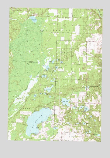
White Potato Lake, WI USGS Topographic Map
Click on map above to begin viewing in our Map Viewer.

This topographic map contains these locations and features:
Feature Name Type Latitude Longitude GNIS ID View Map
Bahlert LakeLakeN45.1421°W88.1561°1561085View Map
Bass LakeLakeN45.1675°W88.2140°1561233View Map
Bass LakeLakeN45.1756°W88.1465°1561234View Map
Brazeau CemeteryCemeteryN45.1547°W88.1879°1562163View Map
Bullhead LakeLakeN45.1996°W88.1905°1562383View Map
Frog LakeLakeN45.1910°W88.1878°1565348View Map
Gaffney LakeLakeN45.1814°W88.1917°1565377View Map
Giese LakeLakeN45.1373°W88.1861°1569939View Map
Gilas LakeLakeN45.1619°W88.1730°1565510View Map
Grass LakeLakeN45.2394°W88.2178°1565765View Map
Halfmoon LakeLakeN45.1859°W88.2023°1565977View Map
Heisel LakeLakeN45.1418°W88.1676°1566271View Map
Holt LakeLakeN45.1695°W88.2067°1566569View Map
House LakeLakeN45.1335°W88.1444°1566762View Map
Little Bass LakeLakeN45.1637°W88.2149°1568173View Map
Little Nelligan LakeLakeN45.1570°W88.1519°1568334View Map
Little Pickerel LakeLakeN45.1953°W88.2020°2784190View Map
Marsh LakeLakeN45.1345°W88.1401°1569076View Map
Marsh LakeLakeN45.1676°W88.2231°2784192View Map
Marsh Lake DamDamN45.1333°W88.1384°1792483View Map
Mattrich LakeLakeN45.1566°W88.1615°1569130View Map
Mud LakeLakeN45.1994°W88.1792°1569942View Map
Mud LakeLakeN45.1375°W88.1857°1845600View Map
Murphy LakeLakeN45.1314°W88.1281°1570044View Map
Napper School (historical)SchoolN45.2191°W88.1659°1845601View Map
Nelligan LakeLakeN45.1556°W88.1451°1570151View Map
Nelligan LakeReservoirN45.1533°W88.1468°1792511View Map
Nelligan Lake 2WP2564 DamDamN45.1533°W88.1468°1792510View Map
Newbar LakeLakeN45.1419°W88.1477°1570243View Map
North Branch Peshtigo BrookStreamN45.1816°W88.2207°1570388View Map
Patz Airport (historical)AirportN45.1297°W88.1648°1582157View Map
Perch LakeLakeN45.1668°W88.1942°1571199View Map
Perch LakeLakeN45.2014°W88.1851°1571200View Map
Pickerel LakeLakeN45.1939°W88.1979°1571317View Map
Rainbow LakeLakeN45.1385°W88.1386°1572039View Map
Ranch LakeLakeN45.1735°W88.1962°1572055View Map
Reader LakeLakeN45.1695°W88.2005°1572119View Map
Reeds Hill School (historical)SchoolN45.1600°W88.1254°1845624View Map
Stephenson Municipal Fire Department Station 2BuildingN45.2473°W88.2302°2696838View Map
West Branch Peshtigo BrookStreamN45.1816°W88.2207°1580748View Map
White Potato LakeLakeN45.1443°W88.2107°1576650View Map
White Potato Lake School (historical)SchoolN45.1294°W88.1670°1845657View Map
Yankee LakeLakeN45.1943°W88.1858°1577078View Map

Note: Coordinates in the location and feature list above are referenced to NAD83 datum.


Copyright (C) 2008-2024 Ryan Niemi / Sunset Dynamics ... All Rights Reserved