TopoQuest Logo
Do you find TopoQuest useful?
Help keep TopoQuest running and adding new maps/features by donating!
Bitcoin:  19c7KJd3qBynnjoSw5npx9KScwjBe4ifkT
Litecoin:  LXs6TkuXGGXo1vDsWCkWVdjQX94eUKd6ui
Home View Maps Find Maps Find Places Resources & Links


High Falls Reservoir, Wisconsin Topographic Map

USGS Map Title: High Falls Reservoir, WI
USGS Map MRC: 45088C2
DRG (GeoTIFF) Download: o45088c2.tif


Neighboring USGS Topographic Map Quads:


  Roaring Rapids, WI  
45088D3
 

  Lehman Lake, WI  
45088D2
 

  Athelstane, WI  
45088D1
 

  Thunder Mountain, WI  
45088C3
 

  High Falls Reservoir, WI  
45088C2
 

  Mount Tom, WI  
45088C1
 

  Shay Lake, WI  
45088B3
 

  White Potato Lake, WI  
45088B2
 

  Crivitz, WI  
45088B1


Map MRC Location:

N46°
W89°
N46°
W88°
H8 H7 H6 H5 H4 H3 H2 H1
G8 G7 G6 G5 G4 G3 G2 G1
F8 F7 F6 F5 F4 F3 F2 F1
E8 E7 E6 E5 E4 E3 E2 E1
D8 D7 D6 D5 D4 D3 D2 D1
C8 C7 C6 C5 C4 C3 C2 C1
B8 B7 B6 B5 B4 B3 B2 B1
A8 A7 A6 A5 A4 A3 A2 A1
N45°
W89°
N45°
W88°

High Falls Reservoir, WI USGS 1:24K Topographic Map Preview:
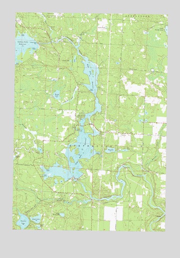
High Falls Reservoir, WI USGS Topographic Map
Click on map above to begin viewing in our Map Viewer.

This topographic map contains these locations and features:
Feature Name Type Latitude Longitude GNIS ID View Map
Angle LakeLakeN45.3475°W88.2046°1560873View Map
Caldron Falls DamDamN45.3573°W88.2317°1562508View Map
Caldron Falls Reservoir 496ReservoirN45.3566°W88.2318°1792994View Map
Caldron Falls School (historical)SchoolN45.3514°W88.2323°1845548View Map
Caldron Falls WP186 DamDamN45.3566°W88.2318°1792993View Map
Eagle CreekStreamN45.3558°W88.1984°1564239View Map
Eagle LakeLakeN45.2562°W88.2303°1564245View Map
Glen Lake DamDamN45.2966°W88.1551°1792799View Map
High Falls 2WP928 DamDamN45.2800°W88.2001°1792983View Map
High Falls DamDamN45.2797°W88.1993°1566375View Map
High Falls ReservoirReservoirN45.3045°W88.1962°1566376View Map
High Falls School (historical)SchoolN45.2761°W88.2007°1845570View Map
Huigen LakeLakeN45.2905°W88.2497°1579495View Map
Island LakeLakeN45.2515°W88.2285°1567010View Map
Johnson Falls DamDamN45.2875°W88.1596°1567224View Map
Johnson Falls Flowage 647ReservoirN45.2676°W88.1794°1792992View Map
Johnson Falls WP 153 DamDamN45.2866°W88.1601°1792991View Map
Joy LakeLakeN45.2963°W88.1605°1567299View Map
Kahles PondLakeN45.3669°W88.1759°1567332View Map
Kiss LakeLakeN45.2964°W88.1710°1567535View Map
Kiss LakeReservoirN45.2966°W88.1551°1792800View Map
Little Eagle CreekStreamN45.3591°W88.2193°1568246View Map
Little Perch LakeLakeN45.2588°W88.2095°1568349View Map
Medbrook LakeLakeN45.3641°W88.1426°2784448View Map
Medicine BrookStreamN45.2822°W88.1423°1569309View Map
Neveln Field Airport (historical)AirportN45.3247°W88.1401°1581935View Map
Old Veteran Lake ParkParkN45.3480°W88.2009°1570789View Map
Old Veterans LakeLakeN45.3484°W88.2010°1845608View Map
Squaw LakeLakeN45.2958°W88.2282°1574770View Map
Stephenson Municipal Fire Department Station 1and Twin Bridge Volunteer Rescue SquadBuildingN45.3067°W88.1637°2696874View Map
Thunder LakeLakeN45.2546°W88.2414°1575428View Map
Thunder Lake InletStreamN45.2602°W88.2448°1580611View Map
Thunder Lake OutletStreamN45.2658°W88.2298°1575429View Map
Thunder RiverStreamN45.2683°W88.1854°1580614View Map
Town of StephensonCivilN45.2764°W88.1512°1584217View Map
Twin Bridge ParkParkN45.3152°W88.1946°1575771View Map
Veterans Memorial ParkParkN45.2691°W88.2098°1845650View Map
Woods LakeLakeN45.3278°W88.2153°1577023View Map
Woods Lake OutletStreamN45.3344°W88.1940°1577025View Map

Note: Coordinates in the location and feature list above are referenced to NAD83 datum.


Copyright (C) 2008-2024 Ryan Niemi / Sunset Dynamics ... All Rights Reserved