TopoQuest Logo
Do you find TopoQuest useful?
Help keep TopoQuest running and adding new maps/features by donating!
Bitcoin:  19c7KJd3qBynnjoSw5npx9KScwjBe4ifkT
Litecoin:  LXs6TkuXGGXo1vDsWCkWVdjQX94eUKd6ui
Home View Maps Find Maps Find Places Resources & Links


White Rock, New Mexico Topographic Map

USGS Map Title: White Rock, NM
USGS Map MRC: 35106G2
DRG (GeoTIFF) Download: o35106g2.tif


Neighboring USGS Topographic Map Quads:


  Guaje Mountain, NM  
35106H3
 

  Puye, NM  
35106H2
 

  Espanola, NM  
35106H1
 

  Frijoles, NM  
35106G3
 

  White Rock, NM  
35106G2
 

  Horcado Ranch, NM  
35106G1
 

  Cochiti Dam, NM  
35106F3
 

  Montoso Peak, NM  
35106F2
 

  Agua Fria, NM  
35106F1


Map MRC Location:

N36°
W107°
N36°
W106°
H8 H7 H6 H5 H4 H3 H2 H1
G8 G7 G6 G5 G4 G3 G2 G1
F8 F7 F6 F5 F4 F3 F2 F1
E8 E7 E6 E5 E4 E3 E2 E1
D8 D7 D6 D5 D4 D3 D2 D1
C8 C7 C6 C5 C4 C3 C2 C1
B8 B7 B6 B5 B4 B3 B2 B1
A8 A7 A6 A5 A4 A3 A2 A1
N35°
W107°
N35°
W106°

White Rock, NM USGS 1:24K Topographic Map Preview:
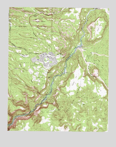
White Rock, NM USGS Topographic Map
Click on map above to begin viewing in our Map Viewer.

This topographic map contains these locations and features:
Feature Name Type Latitude Longitude GNIS ID View Map
Ancho CanyonValleyN35.7706°W106.2184°903147View Map
Ancho RapidRapidsN35.7697°W106.2211°924756View Map
Ancho SpringSpringN35.7750°W106.2281°902595View Map
Basalt SpringSpringN35.8661°W106.1956°902682View Map
Bryce Avenue PresbyterianChurchN35.8275°W106.2039°902140View Map
Bryce Avenue Presbyterian ChurchChurchN35.8275°W106.2039°902411View Map
BuckmanPopulated PlaceN35.8320°W106.1567°904155View Map
Buckman Post Office (historical)Post OfficeN35.8320°W106.1567°938010View Map
Caja del Rio CanyonValleyN35.8339°W106.1620°918085View Map
Caja WellWellN35.7563°W106.1605°913420View Map
Caņada AnchaStreamN35.8353°W106.1656°928697View Map
Caņada de BueyStreamN35.8309°W106.1764°928696View Map
Cedro CanyonValleyN35.8425°W106.2117°904886View Map
Chamisa ElementarySchoolN35.8275°W106.2039°901974View Map
Chaquehui CanyonValleyN35.7631°W106.2414°905034View Map
Chino MesaSummitN35.7700°W106.2084°928712View Map
Christ Community Bible ChurchChurchN35.8275°W106.2039°902714View Map
Church of the Nazarene La VistaChurchN35.8275°W106.2039°902448View Map
Community Evangelical ChurchChurchN35.8275°W106.2039°902530View Map
Community Evangelical Free ChurchChurchN35.8275°W106.2039°901966View Map
Covenant Christian SchoolSchoolN35.8275°W106.2067°934186View Map
Doe SpringsSpringN35.7822°W106.2445°902641View Map
Fence CanyonValleyN35.8092°W106.2278°906251View Map
La MesitaSummitN35.8528°W106.1395°928749View Map
La Vista Church of the NazareneChurchN35.8275°W106.2039°901849View Map
Los Alamos 4 Water WellWellN35.8678°W106.1925°922588View Map
Los Alamos Fire Department Station Number 3BuildingN35.8282°W106.2095°2657566View Map
McKinney Water WellWellN35.8103°W106.1325°925584View Map
Messiah Evangelical Lutheran ChurchChurchN35.8275°W106.2039°901981View Map
Mortandad CanyonValleyN35.8275°W106.1709°908921View Map
NavawiLocaleN35.8275°W106.2039°935988View Map
Navawi RuinsLocaleN35.8478°W106.2142°909030View Map
Ortiz TankReservoirN35.7529°W106.1370°909369View Map
Otowi BridgeBridgeN35.8747°W106.1414°937188View Map
Overlook Picnic AreasLocaleN35.8253°W106.1825°2038602View Map
Pajarito AcresLocaleN35.7939°W106.2084°927266View Map
Pajarito CanyonValleyN35.8028°W106.1936°928766View Map
Pajarito SpringsSpringN35.8047°W106.1981°2038604View Map
Pinabete TankReservoirN35.7720°W106.1884°2038618View Map
Pinon ParkParkN35.8250°W106.2136°2038620View Map
Pinon SchoolSchoolN35.8220°W106.2136°2038621View Map
Pjrto MS 1 Water WellWellN35.8595°W106.2261°922587View Map
Potrillo CanyonValleyN35.7906°W106.2153°928775View Map
Pueblito TankReservoirN35.7609°W106.2306°909873View Map
Pueblo CanyonValleyN35.8692°W106.2075°918299View Map
RG-24666 Water WellWellN35.8253°W106.1431°922594View Map
Sagebrush FlatsFlatN35.8025°W106.1667°910514View Map
Sandia CanyonValleyN35.8336°W106.1659°910741View Map
SF-2A Water WellWellN35.8334°W106.1583°925588View Map
SF-2B Water WellWellN35.8334°W106.1583°925589View Map
SF-2C Water WellWellN35.8334°W106.1583°925590View Map
SF-3A Water WellWellN35.8339°W106.1608°922627View Map
SF-3B Water WellWellN35.8339°W106.1608°922628View Map
SF-3C Water WellWellN35.8339°W106.1625°922629View Map
SF-4A Water WellWellN35.8342°W106.1625°922630View Map
SF-4B Water WellWellN35.8342°W106.1625°922631View Map
SF-4C Water WellWellN35.8342°W106.1625°922632View Map
SF-5A Water WellWellN35.8350°W106.1639°926906View Map
SF-5B Water WellWellN35.8350°W106.1639°926907View Map
SF-5C Water WellWellN35.8350°W106.1639°926908View Map
Soda SpringsSpringN35.8084°W106.1782°2038686View Map
Spring 3SpringN35.8192°W106.1803°920845View Map
Spring 3AASpringN35.8145°W106.1797°920844View Map
Spring 4SpringN35.8050°W106.1936°920843View Map
Spring 5ASpringN35.7884°W106.1945°920842View Map
Spring 5BSpringN35.7770°W106.2133°920841View Map
Spring 7SpringN35.7647°W106.2345°920838View Map
Spring 8SpringN35.7642°W106.2345°920839View Map
Spring 9SpringN35.7642°W106.2406°920840View Map
Stoney TankReservoirN35.7778°W106.1576°911439View Map
The Church of Jesus Christ of Latter Day SaintsChurchN35.8275°W106.2039°901899View Map
The Village Shopping CenterLocaleN35.8259°W106.2089°901232View Map
Totavi Post Office (historical)Post OfficeN35.8745°W106.1797°937805View Map
Tsankawi RuinsLocaleN35.8620°W106.2153°928832View Map
Water CanyonValleyN35.7853°W106.2053°918404View Map
White RockPopulated PlaceN35.8275°W106.2039°912322View Map
White Rock Baptist ChurchChurchN35.8275°W106.2039°901788View Map
White Rock Census Designated PlaceCensusN35.8075°W106.2067°2409584View Map
White Rock DivisionCivilN35.7891°W106.2336°1937618View Map
White Rock Post OfficePost OfficeN35.8252°W106.2111°2781547View Map
White Rock Presbyterian ChurchChurchN35.8275°W106.2039°920399View Map
White Rock Shopping CenterLocaleN35.8275°W106.2067°901257View Map
White Rock United Methodist ChurchChurchN35.8275°W106.2039°901833View Map
White Rock United Presbyterian ChurchChurchN35.8275°W106.2039°901820View Map
Whiterock Baptist ChurchChurchN35.8275°W106.2039°902717View Map

Note: Coordinates in the location and feature list above are referenced to NAD83 datum.


Copyright (C) 2008-2024 Ryan Niemi / Sunset Dynamics ... All Rights Reserved