TopoQuest Logo
Do you find TopoQuest useful?
Help keep TopoQuest running and adding new maps/features by donating!
Bitcoin:  19c7KJd3qBynnjoSw5npx9KScwjBe4ifkT
Litecoin:  LXs6TkuXGGXo1vDsWCkWVdjQX94eUKd6ui
Home View Maps Find Maps Find Places Resources & Links


Puye, New Mexico Topographic Map

USGS Map Title: Puye, NM
USGS Map MRC: 35106H2
DRG (GeoTIFF) Download: o35106h2.tif


Neighboring USGS Topographic Map Quads:


  Vallecitos, NM  
36106A3
 

  Chili, NM  
36106A2
 

  San Juan Pueblo, NM  
36106A1
 

  Guaje Mountain, NM  
35106H3
 

  Puye, NM  
35106H2
 

  Espanola, NM  
35106H1
 

  Frijoles, NM  
35106G3
 

  White Rock, NM  
35106G2
 

  Horcado Ranch, NM  
35106G1


Map MRC Location:

N36°
W107°
N36°
W106°
H8 H7 H6 H5 H4 H3 H2 H1
G8 G7 G6 G5 G4 G3 G2 G1
F8 F7 F6 F5 F4 F3 F2 F1
E8 E7 E6 E5 E4 E3 E2 E1
D8 D7 D6 D5 D4 D3 D2 D1
C8 C7 C6 C5 C4 C3 C2 C1
B8 B7 B6 B5 B4 B3 B2 B1
A8 A7 A6 A5 A4 A3 A2 A1
N35°
W107°
N35°
W106°

Puye, NM USGS 1:24K Topographic Map Preview:
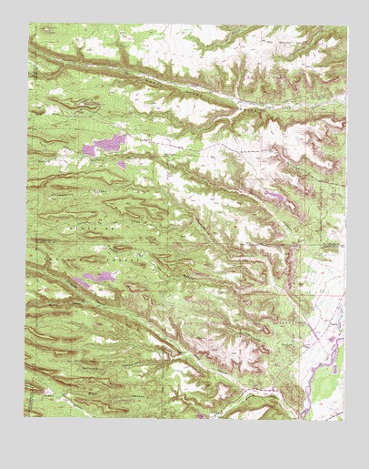
Puye, NM USGS Topographic Map
Click on map above to begin viewing in our Map Viewer.

This topographic map contains these locations and features:
Feature Name Type Latitude Longitude GNIS ID View Map
10159 Water WellWellN35.9031°W106.1284°925597View Map
Barrancas CanyonValleyN35.8959°W106.1853°918076View Map
Bayo CanyonValleyN35.8761°W106.1750°903616View Map
Caņada de las LatasValleyN35.9370°W106.1834°918091View Map
Caņada de las MariasValleyN35.9170°W106.1528°918092View Map
Chupaderos CanyonValleyN35.9072°W106.1397°928713View Map
Contrayerba CanyonValleyN35.8975°W106.1381°928717View Map
Copar MineMineN35.9236°W106.2381°917673View Map
Copar Pumice MineMineN35.9186°W106.2222°916014View Map
Corral CanyonValleyN35.9575°W106.2281°905370View Map
Garcia CanyonValleyN35.9178°W106.1270°918192View Map
General Pumice MineMineN35.9625°W106.2139°906515View Map
Guaje 1 Water WellWellN35.9020°W106.1970°925596View Map
Guaje 1-A Water WellWellN35.9034°W106.1997°922581View Map
Guaje 2 Water WellWellN35.9061°W106.2031°922582View Map
Guaje 3 Water WellWellN35.9089°W106.2128°922583View Map
Guaje 4 WellWellN35.9100°W106.2214°922584View Map
Guaje 5 Water WellWellN35.9142°W106.2275°922585View Map
Guaje CanyonValleyN35.8842°W106.1631°928738View Map
Guaye Trick TankReservoirN35.9400°W106.2186°913470View Map
LA 6 Water WellWellN35.8772°W106.1747°922589View Map
Los Alamos 1B Water WellWellN35.8834°W106.1570°925593View Map
Los Alamos 3 Water WellWellN35.8842°W106.1634°925594View Map
Los Alamos CanyonValleyN35.8753°W106.1406°918233View Map
OtowiPopulated PlaceN35.8759°W106.1425°918276View Map
Otowi Post Office (historical)Post OfficeN35.8759°W106.1425°938239View Map
Otowi RuinsLocaleN35.8822°W106.2328°909396View Map
PajaritoPopulated PlaceN35.9053°W106.1272°918279View Map
PopawiArchN35.9739°W106.2231°1679027View Map
Pumice Mine PumpLocaleN35.9061°W106.2031°913465View Map
PuyePopulated PlaceN35.9717°W106.2303°918307View Map
Puye Cliff DwellingsLocaleN35.9756°W106.2275°913471View Map
Puye Cliff Dwellings (historical)LocaleN35.9717°W106.2303°901503View Map
Puye Cliff Dwellings National Historic LandmarkLocaleN35.9736°W106.2286°937195View Map
Puye Ruins Historical MarkerParkN35.9717°W106.2303°932316View Map
RC-17901 Water WellWellN35.8814°W106.1339°925592View Map
Rendija CanyonValleyN35.9106°W106.2214°910123View Map
San Ildefonso PuebloCivilN35.8819°W106.1520°918342View Map
Santa Clara PuebloCivilN35.9779°W106.2054°937196View Map
Santa Clara Pueblo DivisionCivilN35.9720°W106.1642°1937584View Map
Santa Clara Pueblo DivisionCensusN35.9720°W106.1639°2378255View Map
Santa Clara Pumice Pit 3MineN35.9656°W106.2139°917288View Map
Sawyer CanyonValleyN35.9700°W106.2270°918357View Map
Test 3 Water WellWellN35.8845°W106.1506°925595View Map
TotaviPopulated PlaceN35.8756°W106.1753°918386View Map
White Eagle Pumice MineMineN35.9092°W106.2075°917940View Map
White Eagle Pumice MineMineN35.9128°W106.2042°917438View Map
White Eagle Pumice MineMineN35.9125°W106.2039°912295View Map

Note: Coordinates in the location and feature list above are referenced to NAD83 datum.


Copyright (C) 2008-2024 Ryan Niemi / Sunset Dynamics ... All Rights Reserved