TopoQuest Logo
Do you find TopoQuest useful?
Help keep TopoQuest running and adding new maps/features by donating!
Bitcoin:  19c7KJd3qBynnjoSw5npx9KScwjBe4ifkT
Litecoin:  LXs6TkuXGGXo1vDsWCkWVdjQX94eUKd6ui
Home View Maps Find Maps Find Places Resources & Links


White Swan, Washington Topographic Map

USGS Map Title: White Swan, WA
USGS Map MRC: 46120D6
DRG (GeoTIFF) Download: o46120d6.tif


Neighboring USGS Topographic Map Quads:


  Tampico, WA  
46120E7
 

  Wiley City, WA  
46120E6
 

  Yakima West, WA  
46120E5
 

  Medicine Valley, WA  
46120D7
 

  White Swan, WA  
46120D6
 

  Harrah, WA  
46120D5
 

  Fort Simcoe, WA  
46120C7
 

  Toppenish Mountain, WA  
46120C6
 

  Harrah SE, WA  
46120C5


Map MRC Location:

N47°
W121°
N47°
W120°
H8 H7 H6 H5 H4 H3 H2 H1
G8 G7 G6 G5 G4 G3 G2 G1
F8 F7 F6 F5 F4 F3 F2 F1
E8 E7 E6 E5 E4 E3 E2 E1
D8 D7 D6 D5 D4 D3 D2 D1
C8 C7 C6 C5 C4 C3 C2 C1
B8 B7 B6 B5 B4 B3 B2 B1
A8 A7 A6 A5 A4 A3 A2 A1
N46°
W121°
N46°
W120°

White Swan, WA USGS 1:24K Topographic Map Preview:
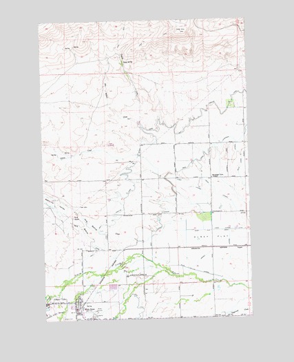
White Swan, WA USGS Topographic Map
Click on map above to begin viewing in our Map Viewer.

This topographic map contains these locations and features:
Feature Name Type Latitude Longitude GNIS ID View Map
Agency CreekStreamN46.3854°W120.7470°1515749View Map
Ayres LateralCanalN46.4298°W120.6615°1503088View Map
Barney Pacific LateralCanalN46.4035°W120.6481°1503185View Map
Harrah AirportAirportN46.4082°W120.6345°1533788View Map
Hitchcock Airstrip (historical)AirportN46.3776°W120.7476°1534034View Map
Indian LateralCanalN46.4296°W120.6476°1505723View Map
Kent RanchLocaleN46.4182°W120.7331°1505953View Map
Latum CreekStreamN46.4460°W120.7165°1506101View Map
Main Canal ExtensionCanalN46.4501°W120.6370°1506435View Map
Medicine ValleyValleyN46.4157°W120.6715°1506613View Map
Mount Adams Middle SchoolSchoolN46.3791°W120.7321°1515260View Map
Mountain View SchoolSchoolN46.4337°W120.6487°1506846View Map
North Medicine CreekStreamN46.4157°W120.6715°1507084View Map
Olney FlatFlatN46.4082°W120.6498°1507169View Map
Olney SpringSpringN46.4827°W120.7009°1507172View Map
Red Willow CreekStreamN46.4551°W120.6912°1513947View Map
RupplePopulated PlaceN46.4043°W120.6312°1511278View Map
Saint Marys CemeteryCemeteryN46.3762°W120.7403°1508027View Map
South Medicine CreekStreamN46.4010°W120.6981°1511558View Map
Tuyuck CreekStreamN46.4548°W120.6909°1509138View Map
West Unit One Highline CanalCanalN46.4537°W120.6865°1513957View Map
White SwanPopulated PlaceN46.3829°W120.7312°1531917View Map
White Swan AmbulanceBuildingN46.3795°W120.7333°2643445View Map
White Swan Census Designated PlaceCensusN46.3770°W120.7381°2409586View Map
White Swan High SchoolSchoolN46.3794°W120.7321°1515259View Map
White Swan Police DepartmentBuildingN46.3795°W120.7333°2768894View Map
White Swan Post OfficePost OfficeN46.3830°W120.7330°2769225View Map
Yakima CountyCivilN46.4570°W120.7385°1531929View Map
Yakima County Fire District 5 Station 1 White SwanBuildingN46.3836°W120.7305°2619657View Map
Yakima ValleyValleyN46.4161°W120.6344°1510450View Map

Note: Coordinates in the location and feature list above are referenced to NAD83 datum.


Copyright (C) 2008-2024 Ryan Niemi / Sunset Dynamics ... All Rights Reserved