TopoQuest Logo
Do you find TopoQuest useful?
Help keep TopoQuest running and adding new maps/features by donating!
Bitcoin:  19c7KJd3qBynnjoSw5npx9KScwjBe4ifkT
Litecoin:  LXs6TkuXGGXo1vDsWCkWVdjQX94eUKd6ui
Home View Maps Find Maps Find Places Resources & Links


Whitney Island North, Louisiana Topographic Map

USGS Map Title: Whitney Island North, LA
USGS Map MRC: 32091F6
DRG (GeoTIFF) Download: o32091f6.tif


Neighboring USGS Topographic Map Quads:


  Mer Rouge, LA  
32091G7
 

  Bonita SW, LA  
32091G6
 

  Goodwill, LA  
32091G5
 

  Collinston East, LA  
32091F7
 

  Whitney Island North, LA  
32091F6
 

  Bear Skin, LA  
32091F5
 

  Irwin Lake, LA  
32091E7
 

  Whitney Island South, LA  
32091E6
 

  Congo Creek, LA  
32091E5


Map MRC Location:

N33°
W92°
N33°
W91°
H8 H7 H6 H5 H4 H3 H2 H1
G8 G7 G6 G5 G4 G3 G2 G1
F8 F7 F6 F5 F4 F3 F2 F1
E8 E7 E6 E5 E4 E3 E2 E1
D8 D7 D6 D5 D4 D3 D2 D1
C8 C7 C6 C5 C4 C3 C2 C1
B8 B7 B6 B5 B4 B3 B2 B1
A8 A7 A6 A5 A4 A3 A2 A1
N32°
W92°
N32°
W91°

Whitney Island North, LA USGS 1:24K Topographic Map Preview:
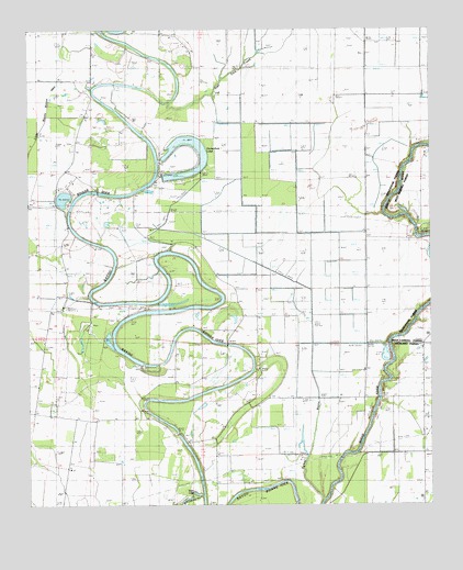
Whitney Island North, LA USGS Topographic Map
Click on map above to begin viewing in our Map Viewer.

This topographic map contains these locations and features:
Feature Name Type Latitude Longitude GNIS ID View Map
Alexander ChurchChurchN32.6415°W91.7010°532103View Map
Bayou Bonne Idee DamDamN32.6601°W91.7285°556954View Map
Cut-Off Number OneBendN32.6271°W91.7015°534315View Map
Deer LakeLakeN32.6279°W91.6977°554214View Map
East Fork CreekStreamN32.7310°W91.7065°534715View Map
Horseshoe ChurchChurchN32.7099°W91.7104°554761View Map
Horseshoe LakeReservoirN32.7120°W91.7015°535818View Map
Horseshoe Lake DamDamN32.7118°W91.7085°556953View Map
Moss BridgeBridgeN32.6440°W91.7037°1630659View Map
Newhope ChurchChurchN32.6682°W91.7462°537662View Map
Parish Governing Authority District 2CivilN32.7261°W91.7481°1929904View Map
Saint Liberty ChurchChurchN32.6971°W91.7373°538937View Map
Trails End ChurchChurchN32.6540°W91.6754°539974View Map
Turkey BayouStreamN32.6268°W91.6582°540029View Map
Ward FiveCivilN32.6387°W91.7496°545132View Map
Wimberley CemeteryCemeteryN32.6296°W91.7398°540491View Map

Note: Coordinates in the location and feature list above are referenced to NAD83 datum.


Copyright (C) 2008-2025 Ryan Niemi / Sunset Dynamics ... All Rights Reserved