TopoQuest Logo
Do you find TopoQuest useful?
Help keep TopoQuest running and adding new maps/features by donating!
Bitcoin:  19c7KJd3qBynnjoSw5npx9KScwjBe4ifkT
Litecoin:  LXs6TkuXGGXo1vDsWCkWVdjQX94eUKd6ui
Home View Maps Find Maps Find Places Resources & Links


Irwin Lake, Louisiana Topographic Map

USGS Map Title: Irwin Lake, LA
USGS Map MRC: 32091E7
DRG (GeoTIFF) Download: o32091e7.tif


Neighboring USGS Topographic Map Quads:


  Collinston West, LA  
32091F8
 

  Collinston East, LA  
32091F7
 

  Whitney Island North, LA  
32091F6
 

  Swartz, LA  
32091E8
 

  Irwin Lake, LA  
32091E7
 

  Whitney Island South, LA  
32091E6
 

  Crew Lake, LA  
32091D8
 

  Rayville, LA  
32091D7
 

  Bee Bayou, LA  
32091D6


Map MRC Location:

N33°
W92°
N33°
W91°
H8 H7 H6 H5 H4 H3 H2 H1
G8 G7 G6 G5 G4 G3 G2 G1
F8 F7 F6 F5 F4 F3 F2 F1
E8 E7 E6 E5 E4 E3 E2 E1
D8 D7 D6 D5 D4 D3 D2 D1
C8 C7 C6 C5 C4 C3 C2 C1
B8 B7 B6 B5 B4 B3 B2 B1
A8 A7 A6 A5 A4 A3 A2 A1
N32°
W92°
N32°
W91°

Irwin Lake, LA USGS 1:24K Topographic Map Preview:
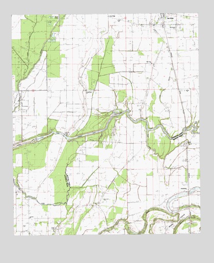
Irwin Lake, LA USGS Topographic Map
Click on map above to begin viewing in our Map Viewer.

This topographic map contains these locations and features:
Feature Name Type Latitude Longitude GNIS ID View Map
Aimwell ChurchChurchN32.5818°W91.7579°540759View Map
Alexandria Church Number 2ChurchN32.6168°W91.7648°540760View Map
Alligator BayouStreamN32.5654°W91.7882°559319View Map
BardelPopulated PlaceN32.5510°W91.7576°542951View Map
Battle ChapelChurchN32.5707°W91.8243°532336View Map
Bayou CouleeStreamN32.6221°W91.8435°553243View Map
BordenaxPopulated PlaceN32.5818°W91.7637°541054View Map
Carter SchoolSchoolN32.5818°W91.8257°533799View Map
Cedar Grove ChurchChurchN32.5971°W91.7821°540762View Map
Cedar Grove SchoolSchoolN32.5965°W91.7810°533842View Map
Como BayouStreamN32.5621°W91.7760°540763View Map
Conger CemeteryCemeteryN32.6224°W91.8029°534079View Map
Cooks SloughGutN32.5501°W91.7701°558905View Map
Dead LakeLakeN32.5529°W91.7854°559676View Map
Easons Ferry (historical)CrossingN32.5610°W91.8123°548678View Map
Irwin LakeReservoirN32.5540°W91.8590°554842View Map
Irwin Lake CemeteryCemeteryN32.5571°W91.8396°540764View Map
James Chapel CemeteryCemeteryN32.5168°W91.8193°536001View Map
Jerusalem ChurchChurchN32.5026°W91.8651°536035View Map
Jones Ferry (historical)CrossingN32.5649°W91.7893°559320View Map
JonesburgPopulated PlaceN32.5251°W91.7568°541117View Map
Little Lake LafourcheLakeN32.5218°W91.8629°555086View Map
Lorrlas Ferry (historical)CrossingN32.5043°W91.7871°558906View Map
New Salem CemeteryCemeteryN32.5204°W91.8157°537628View Map
New Salem Church (historical)ChurchN32.5201°W91.8160°548684View Map
Oak RidgePopulated PlaceN32.6240°W91.7729°555528View Map
Oak Ridge Volunteer Fire DepartmentBuildingN32.6244°W91.7733°2673110View Map
Ridges IslandAreaN32.5193°W91.7568°558910View Map
Saint Luke ChurchChurchN32.5510°W91.7579°540772View Map
Smith BridgeBridgeN32.5265°W91.8710°1630665View Map
Smith Plantation (historical)LocaleN32.5460°W91.8521°1630666View Map
Travelers Rest ChurchChurchN32.5818°W91.8257°540766View Map
Village of Oak RidgeCivilN32.6244°W91.7731°2407515View Map
White IslandIslandN32.5049°W91.7690°559724View Map
Wynn CemeteryCemeteryN32.5051°W91.8693°540556View Map

Note: Coordinates in the location and feature list above are referenced to NAD83 datum.


Copyright (C) 2008-2025 Ryan Niemi / Sunset Dynamics ... All Rights Reserved