TopoQuest Logo
Do you find TopoQuest useful?
Help keep TopoQuest running and adding new maps/features by donating!
Bitcoin:  19c7KJd3qBynnjoSw5npx9KScwjBe4ifkT
Litecoin:  LXs6TkuXGGXo1vDsWCkWVdjQX94eUKd6ui
Home View Maps Find Maps Find Places Resources & Links


Wilhoit, Arizona Topographic Map

USGS Map Title: Wilhoit, AZ
USGS Map MRC: 34112D5
DRG (GeoTIFF) Download: o34112d5.tif


Neighboring USGS Topographic Map Quads:


  Skull Valley, AZ  
34112E6
 

  Iron Springs, AZ  
34112E5
 

  Prescott, AZ  
34112E4
 

  Kirkland, AZ  
34112D6
 

  Wilhoit, AZ  
34112D5
 

  Groom Creek, AZ  
34112D4
 

  Peeples Valley, AZ  
34112C6
 

  Walnut Grove, AZ  
34112C5
 

  Battleship Butte, AZ  
34112C4


Map MRC Location:

N35°
W113°
N35°
W112°
H8 H7 H6 H5 H4 H3 H2 H1
G8 G7 G6 G5 G4 G3 G2 G1
F8 F7 F6 F5 F4 F3 F2 F1
E8 E7 E6 E5 E4 E3 E2 E1
D8 D7 D6 D5 D4 D3 D2 D1
C8 C7 C6 C5 C4 C3 C2 C1
B8 B7 B6 B5 B4 B3 B2 B1
A8 A7 A6 A5 A4 A3 A2 A1
N34°
W113°
N34°
W112°

Wilhoit, AZ USGS 1:24K Topographic Map Preview:
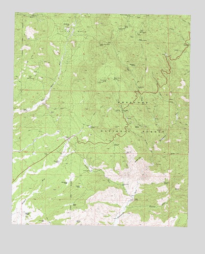
Wilhoit, AZ USGS Topographic Map
Click on map above to begin viewing in our Map Viewer.

This topographic map contains these locations and features:
Feature Name Type Latitude Longitude GNIS ID View Map
Board CreekStreamN34.4236°W112.5260°26555View Map
Board Creek SpringSpringN34.4614°W112.5545°26556View Map
Bootlegger SpringSpringN34.4701°W112.5394°26618View Map
Burro WallowBasinN34.4336°W112.5377°27055View Map
Buzzard Roost WashStreamN34.3867°W112.5446°27114View Map
Buzzard SpringSpringN34.3852°W112.5358°38303View Map
Canfield SpringSpringN34.4859°W112.5582°38316View Map
Climax MineMineN34.4122°W112.5252°27716View Map
Continental MineMineN34.4922°W112.5810°38359View Map
Copper BasinBasinN34.4895°W112.5838°27896View Map
Copper Basin Road SpringSpringN34.4823°W112.5650°27897View Map
Copper CreekStreamN34.4309°W112.5191°27910View Map
Copper Creek WindmillLocaleN34.4570°W112.5374°27916View Map
East Copper SpringSpringN34.4850°W112.5376°28745View Map
Finch WindmillLocaleN34.4984°W112.6135°28994View Map
Forest WindmillLocaleN34.4425°W112.6185°29102View Map
Gabarina HillSummitN34.4922°W112.5871°29236View Map
Glen OaksPopulated PlaceN34.4431°W112.5485°29339View Map
Glen Oaks SpringSpringN34.4431°W112.5526°38460View Map
Government SpringSpringN34.4914°W112.5520°29451View Map
Grassy TankReservoirN34.3775°W112.5797°29551View Map
Hay Flat TankReservoirN34.4125°W112.5926°29795View Map
Head of Aspen Creek SpringSpringN34.4986°W112.5430°29826View Map
Holder TankReservoirN34.3814°W112.6155°30053View Map
Homestead TankReservoirN34.4002°W112.5862°30083View Map
Lee SpringSpringN34.4292°W112.6066°44703View Map
Little Copper CreekStreamN34.4439°W112.5079°31051View Map
Lone Pine SpringSpringN34.4014°W112.5174°31211View Map
McNary SiphonCanalN34.4850°W112.6168°38615View Map
Mint ShaftMineN34.4625°W112.6130°31928View Map
Mount FrancisSummitN34.4889°W112.5354°29165View Map
Mount Francis Trail Forty EightTrailN34.4695°W112.5324°38645View Map
Oro Flame MineMineN34.4528°W112.5004°32559View Map
Orofino TankReservoirN34.3981°W112.5770°32561View Map
Orofino WashStreamN34.3925°W112.5404°32562View Map
Orofino Wash WellWellN34.3995°W112.5474°32563View Map
Orofino WindmillLocaleN34.4072°W112.5699°32564View Map
Pigeon SpringSpringN34.4933°W112.5446°32896View Map
Quartz MountainSummitN34.4147°W112.5346°33277View Map
Riggle TankReservoirN34.3878°W112.5823°33613View Map
Saint Agatha CampgroundLocaleN34.4856°W112.5038°38773View Map
Southern Yavapai Fire DepartmentBuildingN34.4176°W112.5931°2672362View Map
Telegraph SpringSpringN34.4328°W112.5693°41079View Map
Telegraph Spring WindmillLocaleN34.4331°W112.5707°35177View Map
Top of PinesSummitN34.4828°W112.5038°38881View Map
Trap Corral SpringSpringN34.4606°W112.5593°35447View Map
White Rock WaterSpringN34.4417°W112.5499°41080View Map
White Rock WaterSpringN34.4445°W112.5535°44702View Map
White Spar MineMineN34.4178°W112.5446°36106View Map
White Spar WindmillLocaleN34.4228°W112.5535°36107View Map
WilhoitPopulated PlaceN34.4259°W112.5868°36204View Map
Wilhoit Census Designated PlaceCensusN34.4082°W112.6156°2409594View Map
Wilhoit Southern Baptist ChurchChurchN34.4253°W112.5888°2671476View Map
Wilhoit SpringSpringN34.4200°W112.5802°44705View Map
Wilhoit TankReservoirN34.4190°W112.5807°41084View Map

Note: Coordinates in the location and feature list above are referenced to NAD83 datum.


Copyright (C) 2008-2025 Ryan Niemi / Sunset Dynamics ... All Rights Reserved