TopoQuest Logo
Do you find TopoQuest useful?
Help keep TopoQuest running and adding new maps/features by donating!
Bitcoin:  19c7KJd3qBynnjoSw5npx9KScwjBe4ifkT
Litecoin:  LXs6TkuXGGXo1vDsWCkWVdjQX94eUKd6ui
Home View Maps Find Maps Find Places Resources & Links


Battleship Butte, Arizona Topographic Map

USGS Map Title: Battleship Butte, AZ
USGS Map MRC: 34112C4
DRG (GeoTIFF) Download: o34112c4.tif


Neighboring USGS Topographic Map Quads:


  Wilhoit, AZ  
34112D5
 

  Groom Creek, AZ  
34112D4
 

  Poland Junction, AZ  
34112D3
 

  Walnut Grove, AZ  
34112C5
 

  Battleship Butte, AZ  
34112C4
 

  Battle Flat, AZ  
34112C3
 

  Wagoner, AZ  
34112B5
 

  Minnehaha, AZ  
34112B4
 

  Crown King, AZ  
34112B3


Map MRC Location:

N35°
W113°
N35°
W112°
H8 H7 H6 H5 H4 H3 H2 H1
G8 G7 G6 G5 G4 G3 G2 G1
F8 F7 F6 F5 F4 F3 F2 F1
E8 E7 E6 E5 E4 E3 E2 E1
D8 D7 D6 D5 D4 D3 D2 D1
C8 C7 C6 C5 C4 C3 C2 C1
B8 B7 B6 B5 B4 B3 B2 B1
A8 A7 A6 A5 A4 A3 A2 A1
N34°
W113°
N34°
W112°

Battleship Butte, AZ USGS 1:24K Topographic Map Preview:
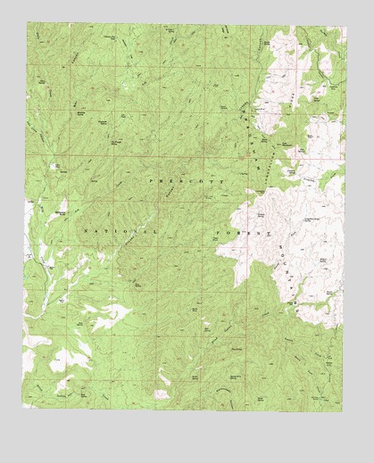
Battleship Butte, AZ USGS Topographic Map
Click on map above to begin viewing in our Map Viewer.

This topographic map contains these locations and features:
Feature Name Type Latitude Longitude GNIS ID View Map
Arrastra SpringSpringN34.3270°W112.3954°25765View Map
Ash CreekStreamN34.2947°W112.4921°25787View Map
Ash TankReservoirN34.3444°W112.4637°25806View Map
Baldwin PlacePopulated PlaceN34.2856°W112.4854°25921View Map
Barrel SpringSpringN34.2888°W112.3794°26010View Map
Battleship ButteSummitN34.3134°W112.4835°26046View Map
Berry SpringSpringN34.2536°W112.4821°38251View Map
Blackjack SpringSpringN34.3429°W112.4684°26460View Map
Bodie MineMineN34.3481°W112.4224°26569View Map
Bodie SpringSpringN34.3379°W112.4060°26570View Map
Box CanyonValleyN34.3320°W112.4896°26683View Map
Butler SpringSpringN34.2607°W112.4344°27082View Map
Cottonwood SpringSpringN34.3322°W112.4643°38375View Map
Crooks CanyonValleyN34.2950°W112.4710°28180View Map
DandreaPopulated PlaceN34.3647°W112.3768°38395View Map
Dandy Wire SpringSpringN34.2609°W112.4198°28264View Map
Deer SpringSpringN34.2904°W112.4573°28390View Map
Deer Trick TankReservoirN34.2967°W112.4538°41018View Map
E Cross L SpringSpringN34.3735°W112.4430°28715View Map
Elouise MineMineN34.3470°W112.4113°28896View Map
Eph SpringSpringN34.2763°W112.4299°28911View Map
Gates SpringSpringN34.3504°W112.3887°29278View Map
GoodwinPopulated PlaceN34.3559°W112.3799°29416View Map
HooperPopulated PlaceN34.2661°W112.3829°30097View Map
Horse SpringSpringN34.2546°W112.4087°30168View Map
Johnson FlatFlatN34.3697°W112.4621°30583View Map
Johnson Flat TankReservoirN34.3704°W112.4654°30585View Map
Longfellow RidgeRidgeN34.3392°W112.4016°31268View Map
Longfellow Ridge SpringSpringN34.3123°W112.3917°31269View Map
Lower TankReservoirN34.2972°W112.4388°38596View Map
Maidenhead CanyonValleyN34.2561°W112.4282°31454View Map
McNary PlacePopulated PlaceN34.2961°W112.4910°31685View Map
McNelty SpringSpringN34.3456°W112.4810°31688View Map
North Fork Blind Indian CreekStreamN34.2817°W112.4032°32360View Map
North Fork SpringSpringN34.2992°W112.4027°38662View Map
North Pine CreekStreamN34.2725°W112.3954°32390View Map
North TankReservoirN34.2992°W112.4024°38667View Map
Orejano SpringSpringN34.3139°W112.4097°32553View Map
Orr SpringSpringN34.2650°W112.3768°38675View Map
Orr Trap CorralLocaleN34.2545°W112.3843°32568View Map
Orr Trap TankReservoirN34.2542°W112.3841°38676View Map
P Bar CampLocaleN34.3284°W112.4891°32604View Map
Pine MountainSummitN34.3364°W112.4007°32954View Map
Pine SpringSpringN34.3346°W112.3917°32973View Map
Pine SpringSpringN34.2634°W112.4302°38699View Map
Pine SpringSpringN34.2702°W112.4195°32971View Map
Pole Camp CanyonValleyN34.3353°W112.4921°33083View Map
Ross SpringSpringN34.2547°W112.4777°33811View Map
Ross SpringSpringN34.2775°W112.4768°33812View Map
Shady DellBasinN34.2850°W112.3952°34298View Map
Shipley WellWellN34.3486°W112.4129°38807View Map
Slate CreekStreamN34.3361°W112.4927°34518View Map
Slate SpringSpringN34.3558°W112.4932°34522View Map
South TankReservoirN34.2827°W112.4348°34686View Map
South Trick TankReservoirN34.2806°W112.4424°41017View Map
Spence SpringSpringN34.3692°W112.4085°34705View Map
Tin Trough SpringSpringN34.3371°W112.4674°35337View Map
Towers CreekStreamN34.2814°W112.4032°35422View Map
Trails End MineMineN34.3186°W112.4279°35440View Map
Upper TankReservoirN34.3051°W112.4272°35720View Map
Walnut SpringSpringN34.2750°W112.3846°38924View Map
West Trick TankReservoirN34.2672°W112.4957°41019View Map
Willow SpringSpringN34.2984°W112.3838°36255View Map
Yankee Boy MineMineN34.3211°W112.4063°36431View Map

Note: Coordinates in the location and feature list above are referenced to NAD83 datum.


Copyright (C) 2008-2025 Ryan Niemi / Sunset Dynamics ... All Rights Reserved