TopoQuest Logo
Do you find TopoQuest useful?
Help keep TopoQuest running and adding new maps/features by donating!
Bitcoin:  19c7KJd3qBynnjoSw5npx9KScwjBe4ifkT
Litecoin:  LXs6TkuXGGXo1vDsWCkWVdjQX94eUKd6ui
Home View Maps Find Maps Find Places Resources & Links


Wilkes-Barre East, Pennsylvania Topographic Map

USGS Map Title: Wilkes-Barre East, PA
USGS Map MRC: 41075B7
DRG (GeoTIFF) Download: o41075b7.tif


Neighboring USGS Topographic Map Quads:


  Kingston, PA  
41075C8
 

  Pittston, PA  
41075C7
 

  Avoca, PA  
41075C6
 

  Wilkes-Barre West, PA  
41075B8
 

  Wilkes-Barre East, PA  
41075B7
 

  Pleasant View Summit, PA  
41075B6
 

  Freeland, PA  
41075A8
 

  White Haven, PA  
41075A7
 

  Hickory Run, PA  
41075A6


Map MRC Location:

N42°
W76°
N42°
W75°
H8 H7 H6 H5 H4 H3 H2 H1
G8 G7 G6 G5 G4 G3 G2 G1
F8 F7 F6 F5 F4 F3 F2 F1
E8 E7 E6 E5 E4 E3 E2 E1
D8 D7 D6 D5 D4 D3 D2 D1
C8 C7 C6 C5 C4 C3 C2 C1
B8 B7 B6 B5 B4 B3 B2 B1
A8 A7 A6 A5 A4 A3 A2 A1
N41°
W76°
N41°
W75°

Wilkes-Barre East, PA USGS 1:24K Topographic Map Preview:
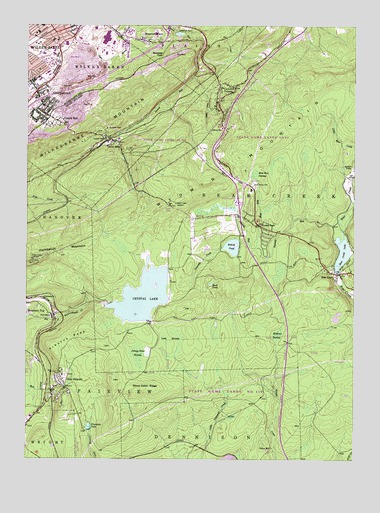
Wilkes-Barre East, PA USGS Topographic Map
Click on map above to begin viewing in our Map Viewer.

This topographic map contains these locations and features:
Feature Name Type Latitude Longitude GNIS ID View Map
Antler LakeReservoirN41.2067°W75.7521°1192074View Map
Arbutus PeakSummitN41.1598°W75.8580°1168370View Map
Bear Creek DamDamN41.1792°W75.7555°1208734View Map
Bear Creek Junction (historical)LocaleN41.1276°W75.8055°1197941View Map
Bear Creek LakeReservoirN41.1847°W75.7542°1168869View Map
Bear Creek Post OfficePost OfficeN41.1768°W75.7537°2773039View Map
Bear Creek Township Volunteer Hose Company Station 13BuildingN41.2018°W75.7881°2653394View Map
Bear Creek VillagePopulated PlaceN41.1787°W75.7563°1217338View Map
Behren PondReservoirN41.1863°W75.7961°1169132View Map
Borough of Bear Creek VillageCivilN41.1877°W75.7552°1217447View Map
Borough of Laurel RunCivilN41.2194°W75.8446°1215398View Map
Boulevard ManorPopulated PlaceN41.2467°W75.8308°1170036View Map
Buck PondLakeN41.1757°W75.8041°1170528View Map
Clear Brook ManorBuildingN41.2198°W75.8476°2718098View Map
Colebrook DamDamN41.2481°W75.8171°1172181View Map
Crystal LakeReservoirN41.1721°W75.8300°1172799View Map
Crystal Lake DamDamN41.1701°W75.8446°1195318View Map
Deep HollowValleyN41.2352°W75.8111°1173062View Map
Eikes Pond DamDamN41.1876°W75.7935°1208733View Map
Forest ParkPopulated PlaceN41.1923°W75.7849°1174981View Map
Fountain LakeReservoirN41.1343°W75.8507°1175053View Map
Geneceda CreekStreamN41.1876°W75.7894°1175511View Map
GeorgetownPopulated PlaceN41.2273°W75.8688°1175540View Map
Georgetown Census Designated PlaceCensusN41.2267°W75.8720°2634422View Map
Glen SummitPopulated PlaceN41.1462°W75.8602°1175710View Map
Glen Summit Post Office (historical)Post OfficeN41.1462°W75.8602°2027108View Map
Glen Summit Springs Post Office (historical)Post OfficeN41.1501°W75.8680°2027107View Map
Glen Summit StationLocaleN41.1501°W75.8680°1212512View Map
GracedalePopulated PlaceN41.1712°W75.8669°1175909View Map
Holy Trinity CemeteryCemeteryN41.2040°W75.7882°1177305View Map
Jimmy Kane SwampSwampN41.1551°W75.8319°1178084View Map
John Heinz Institute of RehabilitationBuildingN41.2464°W75.8544°2718002View Map
Laurel RunPopulated PlaceN41.2223°W75.8630°1192746View Map
Laurel Run and Olivers Mills StationsLocaleN41.2173°W75.8433°1212517View Map
Laurel Run Number Two DamDamN41.2484°W75.8180°1195403View Map
Laurel Run Volunteer Fire DepartmentBuildingN41.2161°W75.8433°2653451View Map
Laurel SchoolSchoolN41.2165°W75.8438°1179028View Map
Liewellyn CornersPopulated PlaceN41.2331°W75.8010°1179321View Map
Llewellyn CornersPopulated PlaceN41.2326°W75.7955°1214249View Map
Long SwampSwampN41.1600°W75.8168°1179905View Map
Macklin Elementary SchoolSchoolN41.2459°W75.8646°1207218View Map
McKean SwampSwampN41.1612°W75.7786°1180733View Map
Meadow Run LakeReservoirN41.2477°W75.8167°1195402View Map
Mountain ParkParkN41.2417°W75.8227°1181955View Map
Mud RunStreamN41.1859°W75.7866°1182028View Map
Mud Run SwampSwampN41.2073°W75.7880°1182038View Map
Ochre MillPopulated PlaceN41.1284°W75.7805°1204320View Map
Oliver MillsPopulated PlaceN41.2170°W75.8419°1182977View Map
Oliver SchoolSchoolN41.2204°W75.7999°1182978View Map
Pennsylvania Turnpike Interchange 36CrossingN41.1984°W75.7941°1196452View Map
PenobscotPopulated PlaceN41.1665°W75.8641°1183557View Map
Prospect RockPillarN41.2197°W75.8519°1184459View Map
Rosenzweig AirportAirportN41.1370°W75.8597°1194179View Map
State Game Lands Number 119ParkN41.1334°W75.7913°1208044View Map
State Game Lands Number 292ParkN41.2126°W75.8330°1208066View Map
Stony Cabin RidgeRidgeN41.1456°W75.8296°1188759View Map
Tenmile RunStreamN41.1912°W75.7538°1189366View Map
Township of Bear CreekCivilN41.1957°W75.7999°1216702View Map
Township of FairviewCivilN41.1580°W75.8633°1216712View Map
Township of Wilkes-BarreCivilN41.2337°W75.8594°1216736View Map
WBRE-TV (Wilkes-Barre)TowerN41.1837°W75.8669°1200557View Map
WCLH-FM (Wilkes-Barre)TowerN41.1829°W75.8721°1200286View Map
Whirlpool Canyon FallsFallsN41.2351°W75.8080°1202471View Map
Wilkes - Barre Township Police DepartmentBuildingN41.2271°W75.8712°2780532View Map
Wilkes - Barre Township Volunteer Fire DepartmentBuildingN41.2275°W75.8703°2653562View Map
Wilkes - Barre Veterans Affairs Medical CenterHospitalN41.2481°W75.8356°2718045View Map
Wilkes Barre Township Elementary SchoolSchoolN41.2290°W75.8713°1207219View Map
Wilkes-Barre Township Census Designated PlaceCensusN41.2335°W75.8595°2390516View Map
WKRZ-FM (Wilkes-Barre)TowerN41.1990°W75.8180°1200291View Map
WNEP-TV (Scranton)TowerN41.1829°W75.8721°1200556View Map
WRKC-FM (Wilkes-Barre)TowerN41.2492°W75.8735°1200300View Map
WVIA-FM (Scranton)TowerN41.1820°W75.8710°1200285View Map
WVIA-TV (Scranton)TowerN41.1820°W75.8710°1200555View Map
Wyoming MountainSummitN41.2159°W75.7832°1191844View Map
WYZZ-FM (Wilkes-Barre)TowerN41.1829°W75.8735°1200287View Map

Note: Coordinates in the location and feature list above are referenced to NAD83 datum.


Copyright (C) 2008-2024 Ryan Niemi / Sunset Dynamics ... All Rights Reserved