TopoQuest Logo
Do you find TopoQuest useful?
Help keep TopoQuest running and adding new maps/features by donating!
Bitcoin:  19c7KJd3qBynnjoSw5npx9KScwjBe4ifkT
Litecoin:  LXs6TkuXGGXo1vDsWCkWVdjQX94eUKd6ui
Home View Maps Find Maps Find Places Resources & Links


Willard, New Mexico Topographic Map

USGS Map Title: Willard, NM
USGS Map MRC: 34106E1
DRG (GeoTIFF) Download: o34106e1.tif


Neighboring USGS Topographic Map Quads:


  Ewing, NM  
34106F2
 

  Mountainair NE, NM  
34106F1
 

  Laguna Del Perro North, NM  
34105F8
 

  Mountainair, NM  
34106E2
 

  Willard, NM  
34106E1
 

  Laguna Del Perro South, NM  
34105E8
 

  Mesa Draw, NM  
34106D2
 

  Round Top, NM  
34106D1
 

  Progresso, NM  
34105D8


Map MRC Location:

N35°
W107°
N35°
W106°
H8 H7 H6 H5 H4 H3 H2 H1
G8 G7 G6 G5 G4 G3 G2 G1
F8 F7 F6 F5 F4 F3 F2 F1
E8 E7 E6 E5 E4 E3 E2 E1
D8 D7 D6 D5 D4 D3 D2 D1
C8 C7 C6 C5 C4 C3 C2 C1
B8 B7 B6 B5 B4 B3 B2 B1
A8 A7 A6 A5 A4 A3 A2 A1
N34°
W107°
N34°
W106°

Willard, NM USGS 1:24K Topographic Map Preview:
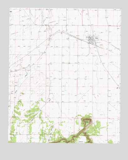
Willard, NM USGS Topographic Map
Click on map above to begin viewing in our Map Viewer.

This topographic map contains these locations and features:
Feature Name Type Latitude Longitude GNIS ID View Map
10004 Water WellWellN34.5815°W106.0656°927055View Map
10005 Water WellWellN34.5745°W106.0656°927053View Map
10019 Water WellWellN34.5815°W106.0439°927054View Map
Brandenburg RanchLocaleN34.6225°W106.0169°886706View Map
BronchoLocaleN34.5570°W106.1145°924473View Map
Bronco PitMineN34.5737°W106.1083°915649View Map
Chavez DrawValleyN34.5259°W106.1233°897337View Map
Dead Dog CanyonValleyN34.5231°W106.0622°888235View Map
Estes WindmillLocaleN34.5892°W106.0942°888926View Map
Farmer CemeteryCemeteryN34.5742°W106.0261°938792View Map
Gustin RanchLocaleN34.5526°W106.0775°889662View Map
Hibler RanchLocaleN34.5090°W106.1150°889935View Map
J & M Farms AirportAirportN34.5870°W106.0747°937043View Map
Jackson RanchLocaleN34.5645°W106.1042°890395View Map
Jumanes KnobSummitN34.5198°W106.0358°890604View Map
Maxey RanchLocaleN34.5545°W106.0617°891690View Map
Protestant CemeteryCemeteryN34.5959°W106.0336°932448View Map
Round Top DrawValleyN34.5448°W106.0650°894193View Map
Tabet DrawValleyN34.5528°W106.1133°924520View Map
Village of WillardCivilN34.5949°W106.0318°2413601View Map
WillardPopulated PlaceN34.5959°W106.0336°896618View Map
Willard Baptist ChurchChurchN34.5959°W106.0336°920935View Map
Willard CemeteryCemeteryN34.6039°W106.0309°896619View Map
Willard CemeteryCemeteryN34.5959°W106.0336°931253View Map
Willard Fire DepartmentBuildingN34.5952°W106.0322°2658154View Map
Willard Post OfficePost OfficeN34.5959°W106.0336°937654View Map
Willard SubstationLocaleN34.6142°W106.0614°929093View Map

Note: Coordinates in the location and feature list above are referenced to NAD83 datum.


Copyright (C) 2008-2025 Ryan Niemi / Sunset Dynamics ... All Rights Reserved