TopoQuest Logo
Do you find TopoQuest useful?
Help keep TopoQuest running and adding new maps/features by donating!
Bitcoin:  19c7KJd3qBynnjoSw5npx9KScwjBe4ifkT
Litecoin:  LXs6TkuXGGXo1vDsWCkWVdjQX94eUKd6ui
Home View Maps Find Maps Find Places Resources & Links


Williams North, Arizona Topographic Map

USGS Map Title: Williams North, AZ
USGS Map MRC: 35112C2
DRG (GeoTIFF) Download: o35112c2.tif


Neighboring USGS Topographic Map Quads:


  Cataract Tank, AZ  
35112D3
 

  Howard Mesa, AZ  
35112D2
 

  Squaw Mountain, AZ  
35112D1
 

  Hearst Mountain, AZ  
35112C3
 

  Williams North, AZ  
35112C2
 

  Sitgreaves Mountain, AZ  
35112C1
 

  McLellan Reservoir, AZ  
35112B3
 

  Williams South, AZ  
35112B2
 

  Davenport Hill, AZ  
35112B1


Map MRC Location:

N36°
W113°
N36°
W112°
H8 H7 H6 H5 H4 H3 H2 H1
G8 G7 G6 G5 G4 G3 G2 G1
F8 F7 F6 F5 F4 F3 F2 F1
E8 E7 E6 E5 E4 E3 E2 E1
D8 D7 D6 D5 D4 D3 D2 D1
C8 C7 C6 C5 C4 C3 C2 C1
B8 B7 B6 B5 B4 B3 B2 B1
A8 A7 A6 A5 A4 A3 A2 A1
N35°
W113°
N35°
W112°

Williams North, AZ USGS 1:24K Topographic Map Preview:
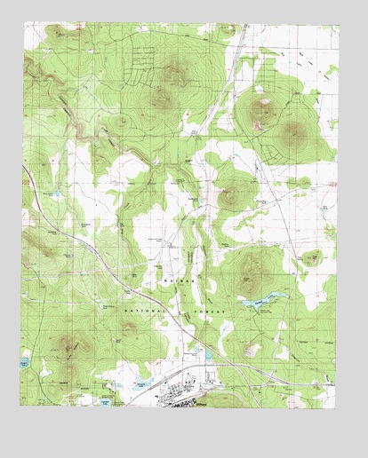
Williams North, AZ USGS Topographic Map
Click on map above to begin viewing in our Map Viewer.

This topographic map contains these locations and features:
Feature Name Type Latitude Longitude GNIS ID View Map
Atchison Topeka and Santa Fe UnderpassCrossingN35.2578°W112.1604°37624View Map
Camp CivitanLocaleN35.3250°W112.1866°37695View Map
Canyon Gateway Recreational Vehicle ParkLocaleN35.2639°W112.1920°2670440View Map
Canyon TankReservoirN35.2989°W112.2309°37698View Map
Cataract LakeLakeN35.2508°W112.2172°27364View Map
Cataract Lake Recreation SiteLocaleN35.2525°W112.2113°37703View Map
City of Williams Rodeo GroundsLocaleN35.2589°W112.1845°2670489View Map
City of Williams Wastewater Treatment PlantLocaleN35.2692°W112.1812°2669617View Map
City of Williams Youth Recreation CenterBuildingN35.2507°W112.1901°2670374View Map
Coconino County Recreation SiteLocaleN35.2539°W112.2185°40590View Map
Dirty Smith TankReservoirN35.3196°W112.2371°40587View Map
Dogtown WashStreamN35.3111°W112.1827°28523View Map
DT TankReservoirN35.2694°W112.1443°37735View Map
Fues HillSummitN35.2995°W112.1354°37805View Map
Fues SpringSpringN35.2986°W112.1410°37806View Map
Fues TankReservoirN35.3149°W112.1317°40589View Map
Gonzalez LakeLakeN35.2572°W112.2029°40586View Map
Grand Canyon - Williams Kampgrounds of AmericaLocaleN35.3290°W112.1588°2670545View Map
Grand Canyon Trading Post (historical)LocaleN35.3242°W112.1546°29465View Map
H A Clark Memorial FieldAirportN35.3037°W112.1928°38179View Map
Holden LakeLakeN35.2643°W112.2489°30048View Map
Junipine Volunteer Fire DepartmentBuildingN35.3590°W112.2115°2672518View Map
Kaibab DamDamN35.2850°W112.1624°37868View Map
Kaibab LakeReservoirN35.2852°W112.1551°30700View Map
Kaibab Lake Recreation Site Kaibab Lake CampgroundLocaleN35.2831°W112.1521°37869View Map
Kaibab Mobile Home ParkPopulated PlaceN35.2604°W112.1771°2670391View Map
KBWA-AM (Williams)TowerN35.2606°W112.1827°43390View Map
KDAN-AM (Williams)TowerN35.2606°W112.1827°45158View Map
Kingdom Hall of Jehovahs WitnessesChurchN35.3321°W112.1592°2671212View Map
Muleshoe TankReservoirN35.3063°W112.2365°37955View Map
Pen TankReservoirN35.3092°W112.2123°37983View Map
Pine Creek WashStreamN35.3278°W112.1996°32931View Map
Pine TankReservoirN35.2926°W112.2071°37993View Map
Pipeline TankReservoirN35.3027°W112.1683°37998View Map
Pit TankReservoirN35.2953°W112.1256°33040View Map
Pitt TankReservoirN35.3436°W112.1818°40588View Map
Prairie Dog TankReservoirN35.3174°W112.1535°38011View Map
Pronghorn RanchLocaleN35.3289°W112.1874°33212View Map
Pronghorn TankReservoirN35.3061°W112.2257°38014View Map
Red Lake Fire DepartmentBuildingN35.3651°W112.1642°2672710View Map
Red Lake ValleyValleyN35.3745°W112.1649°33476View Map
Red TankReservoirN35.3610°W112.1378°38034View Map
Smith LakeLakeN35.3197°W112.2366°34555View Map
Smith TankReservoirN35.2716°W112.2132°38079View Map
Sweetwood TankReservoirN35.3170°W112.1799°35001View Map
Three SistersSummitN35.2692°W112.2316°35297View Map
Three Sisters TankReservoirN35.2825°W112.2227°38112View Map
Threemile LakeLakeN35.2963°W112.1927°35303View Map
Topeka TankReservoirN35.2867°W112.2085°38118View Map
West Cataract Creek DamDamN35.2525°W112.2141°38158View Map
Williams Country ClubLocaleN35.2531°W112.2282°43227View Map
Williams Elementary Middle SchoolSchoolN35.2537°W112.1966°38176View Map
Williams Fire DepartmentBuildingN35.2582°W112.1770°2672612View Map
Williams Little League Park and Municipal Swimming PoolParkN35.2556°W112.1916°38177View Map
Williams Municipal Golf CourseLocaleN35.2550°W112.2279°43406View Map
Williams Overpass (historical)CrossingN35.2556°W112.1760°38180View Map
Williams Post OfficePost OfficeN35.2500°W112.1870°2669937View Map
Williams Railroad StationBuildingN35.2511°W112.1918°38181View Map
Williams Ranger DistrictForestN35.2664°W112.1374°2038762View Map

Note: Coordinates in the location and feature list above are referenced to NAD83 datum.


Copyright (C) 2008-2025 Ryan Niemi / Sunset Dynamics ... All Rights Reserved