TopoQuest Logo
Do you find TopoQuest useful?
Help keep TopoQuest running and adding new maps/features by donating!
Bitcoin:  19c7KJd3qBynnjoSw5npx9KScwjBe4ifkT
Litecoin:  LXs6TkuXGGXo1vDsWCkWVdjQX94eUKd6ui
Home View Maps Find Maps Find Places Resources & Links


Davenport Hill, Arizona Topographic Map

USGS Map Title: Davenport Hill, AZ
USGS Map MRC: 35112B1
DRG (GeoTIFF) Download: o35112b1.tif


Neighboring USGS Topographic Map Quads:


  Williams North, AZ  
35112C2
 

  Sitgreaves Mountain, AZ  
35112C1
 

  Parks, AZ  
35111C8
 

  Williams South, AZ  
35112B2
 

  Davenport Hill, AZ  
35112B1
 

  Garland Prairie, AZ  
35111B8
 

  May Tank Pocket, AZ  
35112A2
 

  White Horse Lake, AZ  
35112A1
 

  Sycamore Point, AZ  
35111A8


Map MRC Location:

N36°
W113°
N36°
W112°
H8 H7 H6 H5 H4 H3 H2 H1
G8 G7 G6 G5 G4 G3 G2 G1
F8 F7 F6 F5 F4 F3 F2 F1
E8 E7 E6 E5 E4 E3 E2 E1
D8 D7 D6 D5 D4 D3 D2 D1
C8 C7 C6 C5 C4 C3 C2 C1
B8 B7 B6 B5 B4 B3 B2 B1
A8 A7 A6 A5 A4 A3 A2 A1
N35°
W113°
N35°
W112°

Davenport Hill, AZ USGS 1:24K Topographic Map Preview:
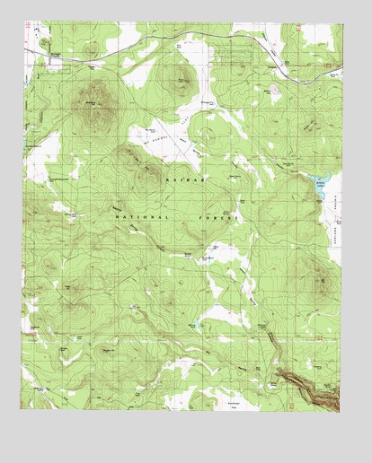
Davenport Hill, AZ USGS Topographic Map
Click on map above to begin viewing in our Map Viewer.

This topographic map contains these locations and features:
Feature Name Type Latitude Longitude GNIS ID View Map
Bear TankReservoirN35.1389°W112.0341°37636View Map
Big SpringSpringN35.1580°W112.0808°26297View Map
Bootlegger CrossingPopulated PlaceN35.2389°W112.1143°37658View Map
Buck SpringSpringN35.1888°W112.0448°26876View Map
Buck TankReservoirN35.1925°W112.0409°40619View Map
Buck Wildlife GuzzlerReservoirN35.1867°W112.0256°2091549View Map
Cat TankReservoirN35.1403°W112.0535°37702View Map
ChalenderPopulated PlaceN35.2345°W112.0252°27478View Map
Davenport HillSummitN35.2236°W112.0974°28286View Map
DeadHorse TankReservoirN35.1510°W112.1226°28326View Map
Dogtown CampgroundLocaleN35.2117°W112.1206°2091544View Map
Dogtown Reservoir Recreation SiteLocaleN35.2092°W112.1246°37750View Map
Dogtown TankReservoirN35.2156°W112.1229°37751View Map
Double TanksReservoirN35.1344°W112.0040°40621View Map
Duck TankReservoirN35.1865°W112.0031°40613View Map
Frenchy CanyonValleyN35.1992°W112.0110°29196View Map
Frog TankReservoirN35.1322°W112.0771°40620View Map
Horse HillSummitN35.2161°W112.0141°30140View Map
Horse Hill Wildlife GuzzlerReservoirN35.2186°W112.0178°2091548View Map
Hyde HillSummitN35.1639°W112.1057°30310View Map
Isham SpringSpringN35.2000°W112.0407°30433View Map
Isham Spring CanyonValleyN35.1567°W112.0313°37849View Map
JD CabinLocaleN35.1403°W112.0568°37850View Map
JD TankReservoirN35.1261°W112.0602°40612View Map
KA HillSummitN35.1670°W112.0093°30699View Map
Lucas TankReservoirN35.1481°W112.1042°40614View Map
McDougal FlatLakeN35.2105°W112.0665°31653View Map
McDougal Flat TankReservoirN35.2241°W112.0511°31654View Map
McDougal SpringSpringN35.1314°W112.1167°31655View Map
Mineral LakeLakeN35.2287°W112.0276°31909View Map
Moose Ranch TankReservoirN35.1740°W112.0557°40618View Map
Moose WellWellN35.1770°W112.0510°32014View Map
Morgan HillSummitN35.1442°W112.0935°32026View Map
New Ranch TankReservoirN35.2149°W112.0738°32291View Map
Pancho Viejo TankReservoirN35.1878°W112.1033°2091547View Map
Pine HillSummitN35.2308°W112.0632°32947View Map
Pine TankPopulated PlaceN35.2420°W112.0660°37991View Map
Pomeroy TankReservoirN35.1394°W112.0079°40615View Map
Pomeroy TanksReservoirN35.1519°W112.0305°33095View Map
Pouquette Homestead TankReservoirN35.1987°W112.1159°33161View Map
Rancho Viejo TankReservoirN35.1876°W112.1043°38026View Map
Reed TankReservoirN35.2374°W112.0244°40616View Map
Reeder TankReservoirN35.2349°W112.0978°33547View Map
Rhodes TankReservoirN35.1443°W112.1105°33595View Map
Rosilda SpringSpringN35.1752°W112.0625°33809View Map
Rosilda Spring CanyonValleyN35.1736°W112.0546°38045View Map
Ross SpringSpringN35.2045°W112.0193°33813View Map
Santa Fe TankReservoirN35.2422°W112.0102°40622View Map
Scholz LakeReservoirN35.1988°W112.0094°38060View Map
Seven Bar K HillSummitN35.2011°W112.0760°34271View Map
Sherwood Forest EstatesPopulated PlaceN35.2406°W112.0449°38070View Map
Sherwood Forest Fire DistrictBuildingN35.2440°W112.0446°2672709View Map
Sunflower FlatFlatN35.1264°W112.0410°34952View Map
Sycamore Rim TrailTrailN35.1647°W112.0147°2091550View Map
Whiting TankReservoirN35.1528°W112.0570°38168View Map
Wilkes TankReservoirN35.1924°W112.0082°40617View Map
Willow SpringSpringN35.1340°W112.0283°36261View Map

Note: Coordinates in the location and feature list above are referenced to NAD83 datum.


Copyright (C) 2008-2025 Ryan Niemi / Sunset Dynamics ... All Rights Reserved