TopoQuest Logo
Do you find TopoQuest useful?
Help keep TopoQuest running and adding new maps/features by donating!
Bitcoin:  19c7KJd3qBynnjoSw5npx9KScwjBe4ifkT
Litecoin:  LXs6TkuXGGXo1vDsWCkWVdjQX94eUKd6ui
Home View Maps Find Maps Find Places Resources & Links


Willow Beach, Arizona Topographic Map

USGS Map Title: Willow Beach, AZ
USGS Map MRC: 35114G6
DRG (GeoTIFF) Download: o35114g6.tif


Neighboring USGS Topographic Map Quads:


  Boulder City, NV  
35114H7
 

  Ringbolt Rapids, AZ  
35114H6
 

  Mount Wilson, AZ  
35114H5
 

  Boulder City SE, NV  
35114G7
 

  Willow Beach, AZ  
35114G6
 

  Housholder Pass, AZ  
35114G5
 

  Nelson, NV  
35114F7
 

  Fire Mountain, AZ  
35114F6
 

  Mohave Mine, AZ  
35114F5


Map MRC Location:

N36°
W115°
N36°
W114°
H8 H7 H6 H5 H4 H3 H2 H1
G8 G7 G6 G5 G4 G3 G2 G1
F8 F7 F6 F5 F4 F3 F2 F1
E8 E7 E6 E5 E4 E3 E2 E1
D8 D7 D6 D5 D4 D3 D2 D1
C8 C7 C6 C5 C4 C3 C2 C1
B8 B7 B6 B5 B4 B3 B2 B1
A8 A7 A6 A5 A4 A3 A2 A1
N35°
W115°
N35°
W114°

Willow Beach, AZ USGS 1:24K Topographic Map Preview:
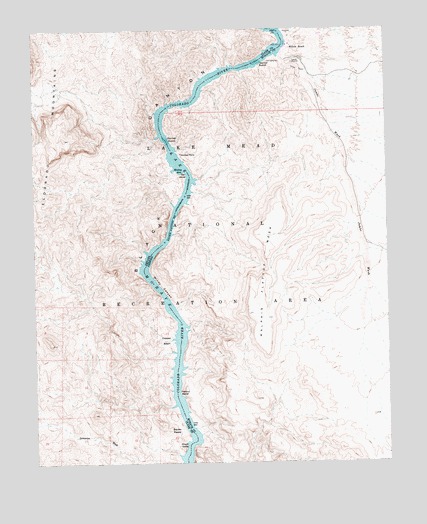
Willow Beach, AZ USGS Topographic Map
Click on map above to begin viewing in our Map Viewer.

This topographic map contains these locations and features:
Feature Name Type Latitude Longitude GNIS ID View Map
Big Horn CoveBayN35.8314°W114.6936°43002View Map
Black CanyonValleyN35.8055°W114.7116°1489View Map
Black CanyonValleyN35.8055°W114.7116°838820View Map
Burro WashBayN35.8442°W114.7064°863714View Map
Chalk CliffsCliffN35.7542°W114.6983°839408View Map
Copper BasinBasinN35.7855°W114.7044°839668View Map
Copper Basin CoveBayN35.7822°W114.7019°863713View Map
Double Neck CoveBayN35.7775°W114.6980°43001View Map
Fenlon BendBendN35.7703°W114.6989°4569View Map
Fenlon Bend CoveBayN35.7661°W114.7022°863712View Map
Grotto WashArroyoN35.8178°W114.7014°43080View Map
Hills Camp (historical)Populated PlaceN35.7767°W114.7011°863845View Map
Jumbo WashValleyN35.8675°W114.6636°6531View Map
Latos PoolsSpringN35.8489°W114.7289°2707804View Map
Malpais Flattop MesaSummitN35.7928°W114.6750°7622View Map
Malpais WashStreamN35.7883°W114.6961°43078View Map
Monkey HoleBayN35.8358°W114.6994°842191View Map
Monkey RockSummitN35.8392°W114.6983°8207View Map
Nevada Sheep CoveBayN35.8111°W114.7111°863696View Map
Painted 8 CoveBayN35.8244°W114.7014°863741View Map
Quenos CoveBayN35.8636°W114.6789°863715View Map
Roaring RapidsRapidsN35.8430°W114.7033°10351View Map
Shallow RapidsRapidsN35.8653°W114.6708°11148View Map
Squaw PeaksSummitN35.7608°W114.7069°843963View Map
Squaw Peaks CoveBayN35.7564°W114.6930°43000View Map
Willow BeachLocaleN35.8703°W114.6594°13821View Map
Willow Beach Sub-District Ranger StationLocaleN35.8672°W114.6611°23300View Map
Windy CanyonValleyN35.7900°W114.6989°13915View Map
Windy CanyonValleyN35.7905°W114.6989°844994View Map

Note: Coordinates in the location and feature list above are referenced to NAD83 datum.


Copyright (C) 2008-2025 Ryan Niemi / Sunset Dynamics ... All Rights Reserved