TopoQuest Logo
Do you find TopoQuest useful?
Help keep TopoQuest running and adding new maps/features by donating!
Bitcoin:  19c7KJd3qBynnjoSw5npx9KScwjBe4ifkT
Litecoin:  LXs6TkuXGGXo1vDsWCkWVdjQX94eUKd6ui
Home View Maps Find Maps Find Places Resources & Links


Wilton, Virginia Topographic Map

USGS Map Title: Wilton, VA
USGS Map MRC: 37076E4
DRG (GeoTIFF) Download: o37076e4.tif


Neighboring USGS Topographic Map Quads:


  Urbanna, VA  
37076F5
 

  Irvington, VA  
37076F4
 

  Fleets Bay, VA  
37076F3
 

  Saluda, VA  
37076E5
 

  Wilton, VA  
37076E4
 

  Deltaville, VA  
37076E3
 

  Gloucester, VA  
37076D5
 

  Ware Neck, VA  
37076D4
 

  Mathews, VA  
37076D3


Map MRC Location:

N38°
W77°
N38°
W76°
H8 H7 H6 H5 H4 H3 H2 H1
G8 G7 G6 G5 G4 G3 G2 G1
F8 F7 F6 F5 F4 F3 F2 F1
E8 E7 E6 E5 E4 E3 E2 E1
D8 D7 D6 D5 D4 D3 D2 D1
C8 C7 C6 C5 C4 C3 C2 C1
B8 B7 B6 B5 B4 B3 B2 B1
A8 A7 A6 A5 A4 A3 A2 A1
N37°
W77°
N37°
W76°

Wilton, VA USGS 1:24K Topographic Map Preview:
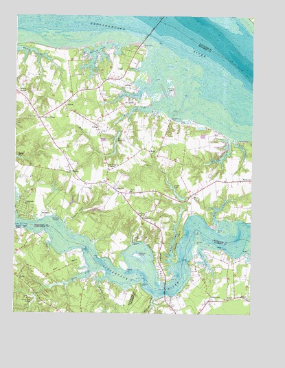
Wilton, VA USGS Topographic Map
Click on map above to begin viewing in our Map Viewer.

This topographic map contains these locations and features:
Feature Name Type Latitude Longitude GNIS ID View Map
BarrettsPopulated PlaceN37.5765°W76.4438°1739477View Map
Barricks DamDamN37.5762°W76.4452°1490410View Map
Barricks MillpondReservoirN37.5704°W76.4472°1490411View Map
Berkley IslandIslandN37.5246°W76.4349°1463095View Map
Blands WharfLocaleN37.5360°W76.4961°1463556View Map
Bush Park CreekStreamN37.5735°W76.3849°1464163View Map
BushyPopulated PlaceN37.5765°W76.4097°1739479View Map
Cheaden (historical)Populated PlaceN37.5612°W76.4897°1739481View Map
Coach Point LandingLocaleN37.5396°W76.4980°1739485View Map
Cobbs CreekStreamN37.5271°W76.4022°1465028View Map
Cobbs CreekPopulated PlaceN37.5057°W76.3969°1499279View Map
Cobbs Creek Post OfficePost OfficeN37.5044°W76.3985°2766448View Map
Conrad PondReservoirN37.5504°W76.4147°1465177View Map
Conrad Wharf (historical)LocaleN37.5412°W76.4063°1739486View Map
Conrads DamDamN37.5482°W76.4102°1490412View Map
Cooper PointCapeN37.5257°W76.4630°1465225View Map
Creek PointCapeN37.5229°W76.4555°1465421View Map
Dancing CreekStreamN37.5149°W76.4513°1465588View Map
Deep PointCapeN37.5362°W76.4955°1465708View Map
Deep Point Landing Boat RampLocaleN37.5361°W76.4953°2518529View Map
DixiePopulated PlaceN37.5007°W76.4144°1499343View Map
Doctor PointCapeN37.5179°W76.4405°1465847View Map
Duck PondLakeN37.5806°W76.4097°1466018View Map
Ebenezer CemeteryCemeteryN37.5062°W76.3874°1739086View Map
Ebenezer ChurchChurchN37.5062°W76.3869°1466146View Map
Elm Bank School (historical)SchoolN37.5035°W76.4772°1761551View Map
Fairfield LandingPopulated PlaceN37.5396°W76.4761°1499402View Map
Ferry CreekStreamN37.5179°W76.4594°1466536View Map
Free Shade CornerPopulated PlaceN37.5604°W76.4502°1466869View Map
French CreekStreamN37.5293°W76.4811°1466886View Map
Garlands LandingLocaleN37.5821°W76.4177°1739488View Map
Ginney PointCapeN37.5296°W76.4036°1467112View Map
Ginney Point MarinaLocaleN37.5249°W76.4024°1739092View Map
Gleaning Baptist ChurchChurchN37.5149°W76.4971°2520324View Map
Glebe NeckCapeN37.5312°W76.4133°1467146View Map
GraftonPopulated PlaceN37.5590°W76.4702°1467332View Map
Great Point WharfLocaleN37.5074°W76.4166°1739094View Map
Grey Point-White Stone Ferry (historical)CrossingN37.6229°W76.4244°1779072View Map
Greys PointCapeN37.6121°W76.4311°1467542View Map
Hardyville Post OfficePost OfficeN37.5562°W76.3751°2767224View Map
Harmony Grove ChurchChurchN37.5815°W76.4883°1467757View Map
Harmony VillagePopulated PlaceN37.5815°W76.4874°1467759View Map
HartfieldPopulated PlaceN37.5512°W76.4461°1499528View Map
Hartfield Post OfficePost OfficeN37.5555°W76.4656°2767225View Map
Hartfield Volunteer Fire DepartmentBuildingN37.5496°W76.4436°2331656View Map
Healy CreekStreamN37.5385°W76.3919°1467889View Map
Hell NeckCapeN37.5201°W76.4730°1467907View Map
Hickory Gate School (historical)SchoolN37.5579°W76.4702°1739492View Map
Holland PointCapeN37.5124°W76.4322°1468137View Map
Horse PointCapeN37.5343°W76.3924°1468271View Map
Hummel FieldAirportN37.6012°W76.4478°1498810View Map
Iron PointCapeN37.5218°W76.4080°1468518View Map
Lancaster Training School (historical)SchoolN37.5674°W76.4527°1739494View Map
LockliesPopulated PlaceN37.5946°W76.4397°1499678View Map
Locklies CreekStreamN37.5935°W76.4347°1477054View Map
Locklies MarinaHarborN37.5938°W76.4347°2518569View Map
Mathews ChapelChurchN37.5068°W76.3766°1470181View Map
Mathews Chapel CemeteryCemeteryN37.5065°W76.3758°1739118View Map
Mathews Volunteer Fire Department Station 4BuildingN37.5036°W76.4001°2331800View Map
Meachim CreekStreamN37.6137°W76.4486°1470286View Map
Mill CreekStreamN37.5862°W76.4280°1470491View Map
Mill Creek Boat RampLocaleN37.5838°W76.4248°2518543View Map
Mount Olive ChurchChurchN37.5410°W76.4327°1470969View Map
New Mill Creek WharfLocaleN37.5818°W76.4174°1471470View Map
Nohead BottomPopulated PlaceN37.5932°W76.4994°1499804View Map
Norris BridgeBridgeN37.6246°W76.4224°1471567View Map
Old Brick ChurchChurchN37.5521°W76.4597°1471827View Map
Parrott IslandIslandN37.5935°W76.4177°1472081View Map
Piankatank River Golf ClubLocaleN37.5557°W76.4789°2520189View Map
Piankatank ShoresPopulated PlaceN37.5457°W76.4955°1499862View Map
Pond PointCapeN37.5274°W76.3899°1472596View Map
Pratts Mill SwampSwampN37.5049°W76.4894°1472762View Map
Prowler MarinaLocaleN37.5260°W76.4008°1739136View Map
Quarter LandingLocaleN37.5926°W76.4433°1739506View Map
RegentPopulated PlaceN37.5882°W76.4416°1477673View Map
Regent Point MarinaHarborN37.5914°W76.4344°2518575View Map
Roane PointCapeN37.5257°W76.3758°1473289View Map
Roanes Point LandingLocaleN37.5251°W76.3788°1739139View Map
Royal Ambassador CampLocaleN37.5321°W76.4358°1473608View Map
Saint Clare Walker Middle SchoolSchoolN37.5909°W76.4985°2464898View Map
Scoggins CreekStreamN37.5379°W76.4736°1474104View Map
Segars LandingLocaleN37.5965°W76.4386°1739508View Map
Shipleys Ferry (historical)CrossingN37.5254°W76.4091°1739143View Map
Silver Hill School (historical)SchoolN37.5890°W76.4933°1739509View Map
Stamper LandingLocaleN37.5299°W76.4372°1739510View Map
StampersPopulated PlaceN37.5399°W76.4324°1475060View Map
Stampers WharfLocaleN37.5301°W76.4352°1475061View Map
SyringaPopulated PlaceN37.5790°W76.4566°1475417View Map
ToppingPopulated PlaceN37.5882°W76.4744°1475786View Map
Topping Post OfficePost OfficeN37.5883°W76.4735°2767263View Map
Twigg BridgeBridgeN37.5104°W76.4197°1739148View Map
Wadinger CreekStreamN37.5065°W76.4244°1476215View Map
WakePopulated PlaceN37.5682°W76.4291°1500267View Map
Wake Launching RampLocaleN37.5840°W76.4249°1739517View Map
Wake Post OfficePost OfficeN37.5680°W76.4295°2766506View Map
WiltonPopulated PlaceN37.5496°W76.4072°1477884View Map
Wilton CreekStreamN37.5190°W76.4149°1476832View Map
Wilton PointCapeN37.5193°W76.4222°1476833View Map
Wilton SchoolSchoolN37.5510°W76.4388°1476834View Map
Woods CreekStreamN37.5729°W76.3833°1476966View Map
WoodstockPopulated PlaceN37.5407°W76.4858°1500351View Map

Note: Coordinates in the location and feature list above are referenced to NAD83 datum.


Copyright (C) 2008-2024 Ryan Niemi / Sunset Dynamics ... All Rights Reserved