TopoQuest Logo
Do you find TopoQuest useful?
Help keep TopoQuest running and adding new maps/features by donating!
Bitcoin:  19c7KJd3qBynnjoSw5npx9KScwjBe4ifkT
Litecoin:  LXs6TkuXGGXo1vDsWCkWVdjQX94eUKd6ui
Home View Maps Find Maps Find Places Resources & Links


Ware Neck, Virginia Topographic Map

USGS Map Title: Ware Neck, VA
USGS Map MRC: 37076D4
DRG (GeoTIFF) Download: o37076d4.tif


Neighboring USGS Topographic Map Quads:


  Saluda, VA  
37076E5
 

  Wilton, VA  
37076E4
 

  Deltaville, VA  
37076E3
 

  Gloucester, VA  
37076D5
 

  Ware Neck, VA  
37076D4
 

  Mathews, VA  
37076D3
 

  Clay Bank, VA  
37076C5
 

  Achilles, VA  
37076C4
 

  New Point Comfort, VA  
37076C3


Map MRC Location:

N38°
W77°
N38°
W76°
H8 H7 H6 H5 H4 H3 H2 H1
G8 G7 G6 G5 G4 G3 G2 G1
F8 F7 F6 F5 F4 F3 F2 F1
E8 E7 E6 E5 E4 E3 E2 E1
D8 D7 D6 D5 D4 D3 D2 D1
C8 C7 C6 C5 C4 C3 C2 C1
B8 B7 B6 B5 B4 B3 B2 B1
A8 A7 A6 A5 A4 A3 A2 A1
N37°
W77°
N37°
W76°

Ware Neck, VA USGS 1:24K Topographic Map Preview:
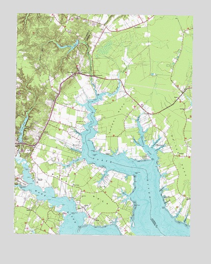
Ware Neck, VA USGS Topographic Map
Click on map above to begin viewing in our Map Viewer.

This topographic map contains these locations and features:
Feature Name Type Latitude Longitude GNIS ID View Map
Auburn WharfLocaleN37.4201°W76.4324°1462613View Map
Auburn Wharf LandingLocaleN37.4201°W76.4322°1739071View Map
Back CreekStreamN37.4185°W76.4519°1462645View Map
BaileysPopulated PlaceN37.3865°W76.4622°1499075View Map
Baileys Wharf BeaconLocaleN37.3871°W76.4591°1491096View Map
Battery School (historical)SchoolN37.4518°W76.4166°1739072View Map
Beaverdam SwampStreamN37.4165°W76.4922°1462976View Map
Belleville CreekStreamN37.4118°W76.4341°1463047View Map
BeulahPopulated PlaceN37.3835°W76.4422°1499128View Map
BlackwaterPopulated PlaceN37.4268°W76.3997°1499143View Map
Blackwater CreekStreamN37.4174°W76.4016°1463533View Map
Burke DamDamN37.4846°W76.4561°1489867View Map
Burke Mill StreamStreamN37.4546°W76.4430°1464112View Map
Burke PondReservoirN37.4818°W76.4624°1501966View Map
Cakes CreekStreamN37.3854°W76.3866°1464241View Map
CardinalPopulated PlaceN37.4204°W76.3816°1499213View Map
Cedar PointCapeN37.3910°W76.3930°1464639View Map
Chapel NeckCapeN37.4429°W76.4283°1464744View Map
Cornerstone Fellowship ChurchChurchN37.4973°W76.4078°2520262View Map
Cow CreekStreamN37.4165°W76.4974°1465340View Map
Cow Creek DamDamN37.4268°W76.4958°1489866View Map
Cow Creek PondReservoirN37.4335°W76.4949°1501994View Map
Cradle PointCapeN37.4224°W76.4430°1465391View Map
Cradle Point LightLocaleN37.4204°W76.4447°1491133View Map
Davis CreekStreamN37.3971°W76.4177°1465650View Map
Diggs CreekStreamN37.3826°W76.3791°1465791View Map
Dixondale (historical)Populated PlaceN37.4321°W76.4619°1761548View Map
DuttonPopulated PlaceN37.4979°W76.4574°1477287View Map
Dutton Post OfficePost OfficeN37.4978°W76.4585°2767211View Map
ElmingtonPopulated PlaceN37.4246°W76.4555°1499383View Map
Elmington CreekStreamN37.4213°W76.4522°1466260View Map
Emmaus CemeteryCemeteryN37.4437°W76.4052°1739087View Map
Emmaus ChurchChurchN37.4440°W76.4058°1466299View Map
Flatiron School (historical)SchoolN37.4246°W76.4858°1761555View Map
Fort NonsensePopulated PlaceN37.4651°W76.4449°1499440View Map
FosterPopulated PlaceN37.4529°W76.3849°1499442View Map
Foster Post OfficePost OfficeN37.4532°W76.3850°2767216View Map
Fox Mill RunStreamN37.4010°W76.4899°1466831View Map
Glen Roy EstatesPopulated PlaceN37.4046°W76.4836°1499477View Map
Greenmansion CoveBayN37.4293°W76.3988°1467504View Map
Hampton CreekStreamN37.4262°W76.4105°1467695View Map
Handy StripAirportN37.4471°W76.4538°1498683View Map
HockleyPopulated PlaceN37.3954°W76.4605°1499566View Map
Hockley WharfLocaleN37.3946°W76.4611°1761567View Map
Holly Point AirportAirportN37.4050°W76.3883°1498739View Map
Horse PointCapeN37.3918°W76.4152°1468270View Map
Hudgins Farm Ultralight Airport (historical)AirportN37.4968°W76.4136°1498636View Map
James StoreLocaleN37.4665°W76.4552°1468633View Map
Jarvis PointCapeN37.3799°W76.4516°1468648View Map
Locust Grove CemeteryCemeteryN37.4896°W76.4386°1739115View Map
Locust Grove ChurchChurchN37.4896°W76.4386°1469725View Map
Lone PointCapeN37.4090°W76.4163°1469748View Map
Lone Point LightLocaleN37.4104°W76.4147°1491185View Map
Macedonia ChurchChurchN37.4468°W76.3805°1469974View Map
Mobjack Bay MarinaHarborN37.4263°W76.4005°2518570View Map
Mount Zion ChurchChurchN37.4507°W76.4727°1471133View Map
NorthLocaleN37.4443°W76.4063°1471572View Map
North End BranchStreamN37.4543°W76.4397°1471593View Map
NuttallPopulated PlaceN37.4326°W76.4802°1499809View Map
Oakland CreekStreamN37.4229°W76.4002°1471785View Map
Parsons BayBayN37.3999°W76.4752°1761577View Map
Pig HillSummitN37.4226°W76.4913°1499865View Map
Pole Bridge CemeteryCemeteryN37.4021°W76.4399°1472574View Map
PribblePopulated PlaceN37.3962°W76.3755°1499913View Map
Raymond CreekStreamN37.4001°W76.3963°1473029View Map
Rising Valley ChurchChurchN37.4665°W76.4591°1473253View Map
Roys PointCapeN37.4185°W76.4036°1473611View Map
SchleyPopulated PlaceN37.3896°W76.4549°1500037View Map
Schley Post OfficePost OfficeN37.3888°W76.4492°2766497View Map
Sibley CemeteryCemeteryN37.3982°W76.3922°1739144View Map
Sibley CreekStreamN37.3965°W76.3944°1474574View Map
Silver CreekStreamN37.3835°W76.4144°1474593View Map
Singleton ChurchChurchN37.3910°W76.4505°1474628View Map
Smith Lot CreekStreamN37.3932°W76.3927°1474763View Map
SolesPopulated PlaceN37.4929°W76.4369°1477767View Map
Spring Hill CemeteryCemeteryN37.4937°W76.4161°1739145View Map
Spring Hill ChurchChurchN37.4935°W76.4166°1475004View Map
Toddsbury CreekStreamN37.4315°W76.4522°1475752View Map
Trinity CemeteryCemeteryN37.4573°W76.3817°1739147View Map
Trinity ChurchChurchN37.4571°W76.3816°1475868View Map
Union Zion ChurchChurchN37.3968°W76.4524°1476097View Map
Ware DistrictCivilN37.4258°W76.4819°1927553View Map
Ware House Boat RampLocaleN37.4034°W76.4898°2518556View Map
Ware NeckPopulated PlaceN37.4026°W76.4586°1476323View Map
Ware NeckCapeN37.4004°W76.4483°1476324View Map
Ware Neck Post OfficePost OfficeN37.4027°W76.4588°2766507View Map
WKEZ-FM (Yorktown)TowerN37.4937°W76.4413°1502735View Map
ZanoniPopulated PlaceN37.3888°W76.4874°1500083View Map

Note: Coordinates in the location and feature list above are referenced to NAD83 datum.


Copyright (C) 2008-2024 Ryan Niemi / Sunset Dynamics ... All Rights Reserved