TopoQuest Logo
Do you find TopoQuest useful?
Help keep TopoQuest running and adding new maps/features by donating!
Bitcoin:  19c7KJd3qBynnjoSw5npx9KScwjBe4ifkT
Litecoin:  LXs6TkuXGGXo1vDsWCkWVdjQX94eUKd6ui
Home View Maps Find Maps Find Places Resources & Links


Windsor, Virginia Topographic Map

USGS Map Title: Windsor, VA
USGS Map MRC: 36076G6
DRG (GeoTIFF) Download: o36076g6.tif


Neighboring USGS Topographic Map Quads:


  Raynor, VA  
36076H7
 

  Smithfield, VA  
36076H6
 

  Benns Church, VA  
36076H5
 

  Zuni, VA  
36076G7
 

  Windsor, VA  
36076G6
 

  Chuckatuck, VA  
36076G5
 

  Holland, VA  
36076F7
 

  Buckhorn, VA  
36076F6
 

  Suffolk, VA  
36076F5


Map MRC Location:

N37°
W77°
N37°
W76°
H8 H7 H6 H5 H4 H3 H2 H1
G8 G7 G6 G5 G4 G3 G2 G1
F8 F7 F6 F5 F4 F3 F2 F1
E8 E7 E6 E5 E4 E3 E2 E1
D8 D7 D6 D5 D4 D3 D2 D1
C8 C7 C6 C5 C4 C3 C2 C1
B8 B7 B6 B5 B4 B3 B2 B1
A8 A7 A6 A5 A4 A3 A2 A1
N36°
W77°
N36°
W76°

Windsor, VA USGS 1:24K Topographic Map Preview:
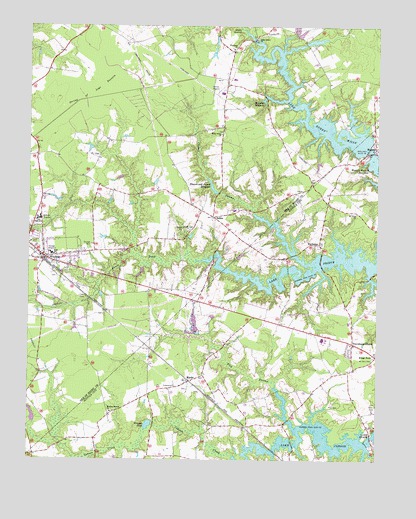
Windsor, VA USGS Topographic Map
Click on map above to begin viewing in our Map Viewer.

This topographic map contains these locations and features:
Feature Name Type Latitude Longitude GNIS ID View Map
Acorn AcresPopulated PlaceN36.7685°W76.6747°1707300View Map
Albert G Horton Junior Memorial Veterans CemeteryCemeteryN36.8247°W76.6404°2770165View Map
Branch and Joyner MillpondReservoirN36.8289°W76.6840°1463751View Map
Carbell SwampStreamN36.8213°W76.6686°1464437View Map
Cohoon CreekStreamN36.7513°W76.6758°1478403View Map
Consulate Health Care of WindsorHospitalN36.8199°W76.7484°2780901View Map
Eley SwampSwampN36.7751°W76.6713°1478548View Map
Ennis PondSwampN36.8090°W76.7127°1466308View Map
EveretsPopulated PlaceN36.8393°W76.6255°1499395View Map
ExchangeLocaleN36.8124°W76.6458°1478572View Map
Exchange School (historical)SchoolN36.8207°W76.6319°1707345View Map
Garner AirportAirportN36.8553°W76.6824°1498855View Map
Great SwampStreamN36.8740°W76.6725°1467450View Map
Greshen School (historical)SchoolN36.7554°W76.7058°1707353View Map
Holly Grove ChurchChurchN36.8440°W76.6808°1468159View Map
Holly Grove School (historical)SchoolN36.8463°W76.6805°1740000View Map
IdlewoodPopulated PlaceN36.7799°W76.6441°1707365View Map
IndikaPopulated PlaceN36.8204°W76.6836°1477434View Map
Jones Grove ChurchChurchN36.8713°W76.6683°1468844View Map
Lake Burnt MillsReservoirN36.8401°W76.6280°1502307View Map
Lake Burnt MillsReservoirN36.8417°W76.6496°1501968View Map
Lake Burnt Mills DamDamN36.8393°W76.6286°1501681View Map
Lake CohoonReservoirN36.7572°W76.6453°1502117View Map
Lake Cohoon DamDamN36.7552°W76.6281°1501680View Map
Lake PrinceReservoirN36.8064°W76.6467°1502102View Map
Lake Prince FarmsPopulated PlaceN36.8010°W76.6397°1707377View Map
Lake Prince MeadowsPopulated PlaceN36.8160°W76.6452°1707378View Map
Lake RhodesReservoirN36.8709°W76.6472°1490120View Map
Lake Rhodes DamDamN36.8718°W76.6463°1490119View Map
Mount Olive ChurchChurchN36.8213°W76.6322°1479148View Map
Mount Zion CemeteryCemeteryN36.7793°W76.6261°1479163View Map
Murphys MillpondReservoirN36.8537°W76.6657°1471275View Map
MyrtlePopulated PlaceN36.7729°W76.6919°1479181View Map
Oliver CemeteryCemeteryN36.7646°W76.6258°1479274View Map
Providence ChurchPopulated PlaceN36.7840°W76.6330°1479387View Map
Pruden Center for Industry / TechnologySchoolN36.7848°W76.6438°1707411View Map
Prudens MillpondReservoirN36.8500°W76.6346°1740015View Map
Scruggs PondReservoirN36.7603°W76.7065°1479561View Map
Shiloh CemeteryCemeteryN36.8163°W76.6919°1474494View Map
String of Logs PocosinSwampN36.8546°W76.7275°1475250View Map
Tandem Health Care of Windsor Nursing HomeBuildingN36.8199°W76.7484°2520054View Map
Town of WindsorCivilN36.8095°W76.7406°2391488View Map
Twin Ponds Mobile Home ParkPopulated PlaceN36.8239°W76.7420°2519947View Map
Tyler CemeteryCemeteryN36.7968°W76.7291°1476011View Map
Western Branch ChurchChurchN36.7638°W76.7197°1479857View Map
Western Bridge Boat RampLocaleN36.8360°W76.6294°2518557View Map
WindsorPopulated PlaceN36.8085°W76.7441°1500328View Map
Windsor Baptist ChurchChurchN36.8088°W76.7436°1740036View Map
Windsor CemeteryCemeteryN36.8028°W76.7389°1740030View Map
Windsor Christian ChurchChurchN36.8093°W76.7444°1740037View Map
Windsor DistrictCivilN36.8674°W76.6688°1927575View Map
Windsor Elementary SchoolSchoolN36.8697°W76.7386°1476013View Map
Windsor High SchoolSchoolN36.8106°W76.7396°1740038View Map
Windsor Manor Mobile Home ParkPopulated PlaceN36.8143°W76.7475°2519953View Map
Windsor Middle SchoolSchoolN36.8107°W76.7389°2465348View Map
Windsor Municipal BuildingBuildingN36.8080°W76.7426°2520549View Map
Windsor Police DepartmentBuildingN36.8064°W76.7359°2768251View Map
Windsor Post OfficePost OfficeN36.8083°W76.7433°2519666View Map
Windsor Public LibraryBuildingN36.8102°W76.7433°2520484View Map
Windsor Volunteer Fire DepartmentBuildingN36.8056°W76.7323°2086217View Map
Windsor Volunteer Rescue SquadBuildingN36.8071°W76.7416°2331821View Map
Windsor Volunteer Rescue SquadBuildingN36.8073°W76.7404°2086219View Map
Woodland ChurchChurchN36.8682°W76.6769°1476945View Map
WXRI-FM (Windsor)TowerN36.8163°W76.6927°1502733View Map

Note: Coordinates in the location and feature list above are referenced to NAD83 datum.


Copyright (C) 2008-2025 Ryan Niemi / Sunset Dynamics ... All Rights Reserved