TopoQuest Logo
Do you find TopoQuest useful?
Help keep TopoQuest running and adding new maps/features by donating!
Bitcoin:  19c7KJd3qBynnjoSw5npx9KScwjBe4ifkT
Litecoin:  LXs6TkuXGGXo1vDsWCkWVdjQX94eUKd6ui
Home View Maps Find Maps Find Places Resources & Links


Wingate, North Carolina Topographic Map

USGS Map Title: Wingate, NC
USGS Map MRC: 34080H4
DRG (GeoTIFF) Download: o34080h4.tif


Neighboring USGS Topographic Map Quads:


  Bakers, NC  
35080A5
 

  Watson, NC  
35080A4
 

  Olive Branch, NC  
35080A3
 

  Monroe, NC  
34080H5
 

  Wingate, NC  
34080H4
 

  Marshville, NC  
34080H3
 

  Tradesville, SC  
34080G5
 

  Pageland, SC  
34080G4
 

  Hornsboro, SC  
34080G3


Map MRC Location:

N35°
W81°
N35°
W80°
H8 H7 H6 H5 H4 H3 H2 H1
G8 G7 G6 G5 G4 G3 G2 G1
F8 F7 F6 F5 F4 F3 F2 F1
E8 E7 E6 E5 E4 E3 E2 E1
D8 D7 D6 D5 D4 D3 D2 D1
C8 C7 C6 C5 C4 C3 C2 C1
B8 B7 B6 B5 B4 B3 B2 B1
A8 A7 A6 A5 A4 A3 A2 A1
N34°
W81°
N34°
W80°

Wingate, NC USGS 1:24K Topographic Map Preview:
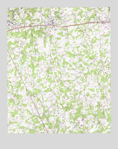
Wingate, NC USGS Topographic Map
Click on map above to begin viewing in our Map Viewer.

This topographic map contains these locations and features:
Feature Name Type Latitude Longitude GNIS ID View Map
Allens CrossroadsPopulated PlaceN34.9121°W80.4076°980122View Map
Allens Crossroads Volunteer Fire Department Station 24BuildingN34.9113°W80.4071°2639248View Map
Austin AuditoriumBuildingN34.9865°W80.4445°1007335View Map
Belk HallBuildingN34.9852°W80.4453°1007324View Map
Bennett - Bivens CemeteryCemeteryN34.9467°W80.3947°2778896View Map
Bennett HallBuildingN34.9877°W80.4462°1007339View Map
Bible Baptist Tabernacle CemeteryCemeteryN34.9904°W80.4968°2776571View Map
Bible TabernacleChurchN34.9910°W80.4978°981292View Map
Braswell LakeReservoirN34.9218°W80.4265°998209View Map
Braswell Lake DamDamN34.9218°W80.4265°998208View Map
Bridges HallBuildingN34.9849°W80.4426°1007329View Map
Budd E Smith Science CenterBuildingN34.9865°W80.4467°1007319View Map
Burnside-Dalton Fine Arts BuildingBuildingN34.9857°W80.4442°1007333View Map
Burris HallBuildingN34.9860°W80.4451°1007323View Map
Cedar BranchStreamN34.9046°W80.3773°982792View Map
Centerview ChurchChurchN34.9232°W80.4023°982945View Map
Centerview Church CemeteryCemeteryN34.9233°W80.4016°2778886View Map
Charles A Cannon Recreational ComplexBuildingN34.9865°W80.4437°1007332View Map
Cowpens BranchStreamN34.8857°W80.4501°983664View Map
Dickson-Palmer CenterBuildingN34.9852°W80.4437°1007328View Map
East Union Middle SchoolSchoolN34.9854°W80.3840°1024823View Map
Ethel K Smith LibraryBuildingN34.9857°W80.4467°1007321View Map
Faulks ChurchChurchN34.9352°W80.4117°985020View Map
Faulks Church CemeteryCemeteryN34.9339°W80.4113°2778887View Map
Flag BranchStreamN34.9790°W80.4709°985139View Map
Flag ChurchChurchN34.9138°W80.4553°985143View Map
Forest Hills High SchoolSchoolN34.9796°W80.4134°985276View Map
Griffin CemeteryCemeteryN34.8964°W80.4530°2778878View Map
Haney BranchStreamN34.9454°W80.3831°986357View Map
Helms HallBuildingN34.9879°W80.4401°1007336View Map
Hendricks HallBuildingN34.9874°W80.4462°1007317View Map
Holbert HallBuildingN34.9879°W80.4462°1007340View Map
Holbrook Administration BuildingBuildingN34.9840°W80.4442°1007326View Map
Horsepen BranchStreamN34.9546°W80.4037°987127View Map
J Herbert Bridges HallBuildingN34.9865°W80.4462°1007320View Map
Joes BranchStreamN34.9968°W80.4915°987619View Map
Laney HallBuildingN34.9860°W80.4442°1007334View Map
Maple Springs BranchStreamN34.9460°W80.3934°989313View Map
McIntyre GymnasiumBuildingN34.9871°W80.4453°1007318View Map
Meadowbranch - Wingate Baptist Church CemeteryCemeteryN34.9832°W80.4465°2776573View Map
Middle Fork Rays ForkStreamN34.9788°W80.4701°989778View Map
Mountain Springs BranchStreamN34.8929°W80.4548°990710View Map
Mountain Springs ChurchChurchN34.9115°W80.4678°990711View Map
Nicey Grove ChurchChurchN34.9721°W80.4323°991145View Map
Nicey Grove Church CemeteryCemeteryN34.9722°W80.4317°2776574View Map
Reedy BranchStreamN34.9352°W80.4078°993170View Map
Rock RestPopulated PlaceN34.9546°W80.4834°1022328View Map
Rushing HallBuildingN34.9854°W80.4420°1007330View Map
Ruth Coltrane Cannon DormitoryBuildingN34.9852°W80.4445°1007331View Map
Sanders-Sikes GymnasiumBuildingN34.9874°W80.4440°1007338View Map
Smyrna ChurchChurchN34.8796°W80.4651°995028View Map
Smyrna Church CemeteryCemeteryN34.8799°W80.4648°2778879View Map
Town of WingateCivilN34.9854°W80.4496°2406902View Map
Tucker HallBuildingN34.9849°W80.4453°1007322View Map
Union Baptist Church CemeteryCemeteryN34.8810°W80.4192°2778885View Map
Union ChurchChurchN34.8815°W80.4187°996448View Map
Union County Sheriff's OfficeBuildingN34.9780°W80.4660°2769697View Map
Union SchoolSchoolN34.8827°W80.4173°996511View Map
W T Hams Dining HallBuildingN34.9843°W80.4434°1007327View Map
Walker Grove ChurchChurchN34.9632°W80.4653°996700View Map
Walker Grove Church CemeteryCemeteryN34.9628°W80.4650°2776575View Map
Waxhaw BranchStreamN34.8904°W80.3917°996881View Map
WingatePopulated PlaceN34.9843°W80.4492°997487View Map
Wingate Baptist ChurchChurchN34.9860°W80.4473°1007325View Map
Wingate CemeteryCemeteryN34.9829°W80.4403°997488View Map
Wingate CollegeSchoolN34.9843°W80.4445°997489View Map
Wingate College Alumni HallBuildingN34.9865°W80.4453°1007337View Map
Wingate Police DepartmentBuildingN34.9823°W80.4456°2769619View Map
Wingate Post OfficePost OfficeN34.9840°W80.4488°2773809View Map
Wingate Volunteer Fire Department Station 9BuildingN34.9837°W80.4487°2638186View Map

Note: Coordinates in the location and feature list above are referenced to NAD83 datum.


Copyright (C) 2008-2024 Ryan Niemi / Sunset Dynamics ... All Rights Reserved