TopoQuest Logo
Do you find TopoQuest useful?
Help keep TopoQuest running and adding new maps/features by donating!
Bitcoin:  19c7KJd3qBynnjoSw5npx9KScwjBe4ifkT
Litecoin:  LXs6TkuXGGXo1vDsWCkWVdjQX94eUKd6ui
Home View Maps Find Maps Find Places Resources & Links


Winger, Minnesota Topographic Map

USGS Map Title: Winger, MN
USGS Map MRC: 47095E8
DRG (GeoTIFF) Download: o47095e8.tif


Neighboring USGS Topographic Map Quads:


  Erskine, MN  
47096F1
 

  McIntosh, MN  
47095F8
 

  McIntosh NE, MN  
47095F7
 

  Union Lake, MN  
47096E1
 

  Winger, MN  
47095E8
 

  Fosston West, MN  
47095E7
 

  Faith NE, MN  
47096D1
 

  Bejou, MN  
47095D8
 

  Mahnomen NE, MN  
47095D7


Map MRC Location:

N48°
W96°
N48°
W95°
H8 H7 H6 H5 H4 H3 H2 H1
G8 G7 G6 G5 G4 G3 G2 G1
F8 F7 F6 F5 F4 F3 F2 F1
E8 E7 E6 E5 E4 E3 E2 E1
D8 D7 D6 D5 D4 D3 D2 D1
C8 C7 C6 C5 C4 C3 C2 C1
B8 B7 B6 B5 B4 B3 B2 B1
A8 A7 A6 A5 A4 A3 A2 A1
N47°
W96°
N47°
W95°

Winger, MN USGS 1:24K Topographic Map Preview:
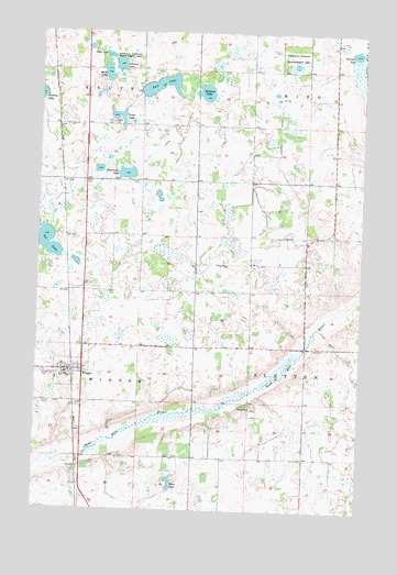
Winger, MN USGS Topographic Map
Click on map above to begin viewing in our Map Viewer.

This topographic map contains these locations and features:
Feature Name Type Latitude Longitude GNIS ID View Map
Bethel CemeteryCemeteryN47.5267°W95.9168°2081295View Map
Bethel ChurchChurchN47.5266°W95.9173°640032View Map
Calvary CemeteryCemeteryN47.5359°W95.9968°2081292View Map
City of WingerCivilN47.5376°W95.9864°2397346View Map
County Ditch Number NinetytwoCanalN47.6041°W95.9075°642378View Map
Dovre CemeteryCemeteryN47.5855°W95.9827°642913View Map
Dovre Lutheran ChurchChurchN47.5361°W95.9881°2081811View Map
Elim CemeteryCemeteryN47.5277°W95.9948°643293View Map
Engemoen LakeLakeN47.5879°W95.9665°643379View Map
Foot LakeLakeN47.6110°W95.9541°643788View Map
Gosen CemeteryCemeteryN47.6011°W95.9722°2081304View Map
Gosen ChurchChurchN47.6011°W95.9723°644282View Map
Gosen LakeLakeN47.6032°W95.9702°644283View Map
Hedman LakeLakeN47.6094°W95.9367°644830View Map
Johnson LakeLakeN47.6161°W95.9701°645706View Map
Lanman LakeLakeN47.6200°W95.8787°646484View Map
Moen LakeLakeN47.5072°W95.9473°648013View Map
Olson LakeLakeN47.6143°W95.9745°648956View Map
Sletten Post Office (historical)Post OfficeN47.5417°W95.8917°2081352View Map
State LakeLakeN47.6187°W95.9743°652585View Map
Tee LakeLakeN47.5709°W95.9978°653067View Map
WingerPopulated PlaceN47.5361°W95.9884°654260View Map
WingerLocaleN47.5361°W95.9858°2081807View Map
Winger CemeteryCemeteryN47.5359°W95.9976°654261View Map
Winger Police DepartmentBuildingN47.5361°W95.9881°2081808View Map
Winger Post OfficePost OfficeN47.5361°W95.9881°2081809View Map
Winger Volunteer Fire DepartmentBuildingN47.5358°W95.9879°2666426View Map

Note: Coordinates in the location and feature list above are referenced to NAD83 datum.


Copyright (C) 2008-2025 Ryan Niemi / Sunset Dynamics ... All Rights Reserved